Lake Bindegolly is a national park in Dynevor, Shire of Bulloo, South West Queensland, Australia, 871 km west of Brisbane and 40 km from the town of Thargomindah. It is in the Mulga Lands bioregion and was established to protect a population of the rare plant Acacia ammophila. It has three lakes, two saline and one freshwater.

Mornington Sanctuary, formerly Mornington Station, is a 3,582 km2 (1,383 sq mi) nature reserve in the Kimberley region of north-west Western Australia. It contains the Mornington Wilderness Camp and is owned and managed by the Australian Wildlife Conservancy (AWC). It lies in the Pentecost subregion of the Central Kimberley Bioregion.

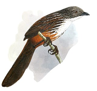
The white-throated grasswren, also known as Yirlinkirrkirr in the local language, is a species of bird in the family Maluridae. It is endemic to northern Australia, found only in West Arnhem Land, in the Northern Territory (NT).

Lockerbie Scrub is a 230 km2 area of closed forest and woodland, surrounded by open tropical savanna woodland, at the northern tip of the Cape York Peninsula in Far North Queensland, Australia.
Ethabuka Reserve is a 213,300 ha (527,000-acre) nature reserve in Central West Queensland, Australia, 157 km (98 mi) north-west of Bedourie, 336 km (209 mi) south-west of Boulia and 639 km (397 mi) south of Mount Isa. It lies at the northern end of the Simpson Desert with its western boundary bordering the Northern Territory. It is owned and managed by Bush Heritage Australia (BHA), who also own the adjacent property, Pilungah Reserve. The elevation of the reserve terrain is 99 meters.

The McIlwraith Range is a rugged, dissected granite plateau on Cape York Peninsula of Far North Queensland, Australia. Part of the Great Dividing Range, the McIlwraith Range covers about 3,000 square kilometres (1,200 sq mi) and lies about 15 kilometres (9.3 mi) east of the town of Coen, and 550 kilometres (340 mi) north of Cairns. The Archer and Stewart Rivers rise in the range, with the Archer draining the range's western slopes into the Gulf of Carpentaria and the Stewart draining east into the Coral Sea. The range receives an annual rainfall of about 1,500 millimetres (59 in).

Granite Downs was a 9,000-square-kilometre (3,475 sq mi) cattle station in arid northern South Australia.

The Keep River Important Bird Area is a 983 square kilometres (380 sq mi) tract of land on the upper Keep River straddling the border between Western Australia and the Northern Territory. It lies at an altitude of 150 m (490 ft) to 210 m (690 ft) and is about 400 km (250 mi) south-west of Darwin and 40 km (25 mi) east of Kununurra.

Lilyvale Important Bird Area is a 35 km2 tract of land on the south-eastern Cape York Peninsula in Far North Queensland, Australia, that is important for bird conservation, and especially for red goshawks.

The Morehead River Important Bird Area comprises a 1356 km2 tract of tropical savanna woodland in the south-eastern Cape York Peninsula of Far North Queensland, Australia.

The Prince Regent and Mitchell River Important Bird Area is a 7333 km2 tract of land comprising several contiguous protected areas in the north-west Kimberley region of northern Western Australia. It includes the Mitchell Plateau.

The Riverland Mallee Important Bird Area comprises a 12,200 square kilometres tract of mallee habitat and riverine woodland extending from near Waikerie in the Riverland region in eastern South Australia north-eastwards into south-western New South Wales.

The Wandown Important Bird Area comprises a 48 km2 disjunct tract of remnant mallee habitat in northern Victoria, south-eastern Australia. It lies close to the junction of the Murray and Murrumbidgee Rivers, some 50 km south-east of the town of Robinvale and 75 km north-west of the city of Swan Hill.

The Wollogorang Important Bird Area is a 726 km2 tract of land straddling the border between the Northern Territory and Queensland in northern Australia.

The Wyndham Important Bird Area comprises a 28 km2 tract of land in the north-east of the Kimberley region of Western Australia. The site lies in the Bastion Hills close to the town of Wyndham, a port on the West Arm of the Cambridge Gulf. It is an important site for Gouldian finches.

The Yinberrie Hills Important Bird Area comprise some 1050 km2 of rocky, tropical savanna covered, wooded hills in the lower Top End of the Northern Territory of Australia. They lie 45 km north of the town of Katherine, and about the same distance south of Pine Creek. The site is important for Gouldian finches.

The Anson Bay, Daly and Reynolds River Floodplains comprise some 2,656 square kilometres (1,025 sq mi) of seasonally inundated floodplains around Anson Bay, and the lower reaches of the Daly, Reynolds and Docherty Rivers entering the bay, on the west coast of the Top End of the Northern Territory of Australia. Anson's Bay lies about 120 kilometres (75 mi) south-west of Darwin, on the eastern side of the Joseph Bonaparte Gulf, opening on to the Timor Sea. The site is important for large numbers, and a wide variety, of waterbirds.

The Buckley River Important Bird Area comprises a 4790 km2 tract of land in the Gulf Country of north-western Queensland, Australia. It lies about 20 km north of the mining city of Mount Isa in the Waggaboonyah Range. It is an important site for Carpentarian grasswrens.

The Cadell and Blyth Floodplains consist of the 432 square kilometres (167 sq mi) floodplain of the lower reaches of the Blyth and Cadell Rivers of northern Arnhem Land in the Top End of the Northern Territory of Australia. It is an important site for waterbirds.


