Pilbara shrublands

Last updated
Pilbara shrublands
Hamersley Range, Pilbara Region, Western Australia.JPG
IBRA 6.1 Pilbara.png
Map of IBRA regions, with Pilbara in red.
Ecology
Realm Australasian
Biome deserts and xeric shrublands
Borders Carnarvon xeric shrublands, Great Sandy-Tanami desert, Kimberley tropical savanna, and Western Australian mulga shrublands
Geography
Area177,693 km2 (68,608 sq mi)
Country Australia
States Western Australia
Coordinates 21°42′S118°42′E / 21.7°S 118.7°E / -21.7; 118.7 Coordinates: 21°42′S118°42′E / 21.7°S 118.7°E / -21.7; 118.7
Conservation
Conservation status Vulnerable
Protected11,224 km² (6%) [1]

The Pilbara shrublands is a deserts and xeric shrublands ecoregion in Western Australia. It is coterminous with the Pilbara IBRA region. [2] [3] For other definitions and uses of "Pilbara region" see Pilbara. [4] [5] [6]

Contents

Geography

The Pilbara shrublands is bounded on the north by the Indian Ocean, and on the west, south, and east by other deserts and xeric shrubland ecoregions - the Carnarvon xeric shrublands to the west, the Western Australian mulga shrublands to the south, and the Great Sandy-Tanami desert to the east and northeast.

The Pilbara geographic region covers most of the ecoregion, and extends east into the Great Sandy desert.

The Hamersley Range, a region of mountain ranges and plateaus dissected by gorges, lies in the southern portion of the ecoregion. The Fortescue Plains extend east and west to the north of the Hamersley Range, forming the upper basin of the Fortescue River. The Chichester Plateau lies north of the Fortescue Plains. The Roebourne subregion encompasses the coastal plain along the Indian Ocean, including the Dampier Archipelago. [7] [8]

The ecoregion lies on the Pilbara craton, a block of ancient Archean rock. The Chichester region is characterized by exposed granite and greenstone basement rocks. The Hamersley region includes iron-rich carbonate sedimentary carbonate rocks over a volcanic substrate (the Fortescue formation) which rest on the older craton. The Fortescue basin and coastal plain are alluvial.

Climate

The climate is tropical semi-desert. Rainfall averages 300 mm annually, typically from summer cyclonic storms and thunderstorms. [8]

Flora

In the Hamersley region, mulga woodland occurs on fine-textured valley soils, with Acacia aneura over the grasses Aristida spp. and Enneapogon spp. Snappy gum (Eucalyptus leucophloia) occurs with the grass Triodia brizoides on the skeletal soils of the ranges. [8]

The Fortescue Plains include the northernmost mulga woodlands, along with short grasslands. Year-round watercourses and springs support stands of red river gum, (Eucalyptus camaldulensis refulgens), Melaleuca , and the palm Livistona alfredii . Sheltered gorges along the edge of the Chichester Plateau provide water and protection from fire, and support relict communities of Terminalia, Erythrina , and Ficus . [9]

The Chichester Plateau is principally scrub steppe, with the shrub Acacia inaequilatera and the bunch grass Triodia wiseana . Scrub steppe also dominates the Roebourne coastal plain, with Acacia translucens and Triodia pungens . [7]

Fauna

Native animals include the red kangaroo (Osphranter rufus), bilby (Macrotis lagotis), northern quoll (Dasyurus hallucatus), Pilbara leaf-nosed bat (Rhinonicteris aurantia, Pilbara form), ghost bat (Macroderma gigas), Pilbara ningaui (Ningaui timealeyi), Pilbara olive python (Liasis olivaceus barroni), Pilbara bandy bandy (Vermicella snelli), and Airlie Island ctenotus (Ctenotus angusticeps). [10]

Rothschild's rock-wallaby (Petrogale rothschildi), Pilbara rock monitor (Varanus pilbarensis), Pilbara death adder (Acanthophis wellsi), Pilbara toadlet (Uperoleia saxatilis), and the Pilbara threadtail (Nososticta pilbara) are endemic to the ecoregion.

Subregions

IBRA regions and subregions: IBRA7
IBRA region / subregionIBRA codeArea States scope="col" Location in Australia
PilbaraPIL17,823,126 hectares (44,041,900 acres)WA IBRA 6.1 Pilbara.png
Chichester PIL018,374,728 hectares (20,694,400 acres)
Fortescue PIL021,951,435 hectares (4,822,100 acres)
Hamersley PIL035,634,727 hectares (13,923,710 acres)
Roebourne PIL041,862,236 hectares (4,601,690 acres)

Protected areas

6.47% of the ecoregion is in protected areas. Protected areas include: [5]

Related Research Articles

<span class="mw-page-title-main">Great Victoria Desert</span> Desert in Western Australia and South Australia

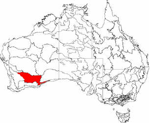
The Great Victoria Desert is a sparsely populated desert ecoregion and interim Australian bioregion in Western Australia and South Australia.

<span class="mw-page-title-main">Millstream Chichester National Park</span> Protected area in Western Australia

Millstream Chichester National Park is a national park in the Pilbara region of Western Australia, located 1,190 kilometres (739 mi) north of the state capital, Perth.

The Pilbara is a large, dry, thinly populated region in the north of Western Australia. It is known for its Aboriginal peoples; its ancient landscapes; the red earth; and its vast mineral deposits, in particular iron ore. It is also a global biodiversity hotspot for subterranean fauna.

<span class="mw-page-title-main">Carnarvon xeric shrublands</span> Terrestrial ecoregion in Western Australia

The Carnarvon xeric shrublands is a deserts and xeric shrublands ecoregion of Western Australia. The ecoregion is coterminous with the Carnarvon Interim Biogeographic Regionalisation for Australia (IBRA) bioregion.

<span class="mw-page-title-main">Murchison bioregion</span> Bioregion in Western Australia

The Murchison is an interim Australian bioregion located within the Mid West of Western Australia. The bioregion is loosely related to the catchment area of the Murchison River and has an area of 281,205 square kilometres (108,574 sq mi). Traditionally the region is known as The Murchison.

<span class="mw-page-title-main">Deserts of Australia</span> Deserts in Australia

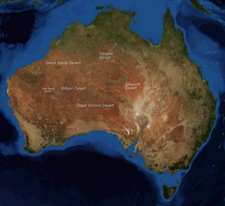
The deserts of Australia or the Australian deserts cover about 2,700,000 km2 (1,000,000 sq mi), or 18% of the Australian mainland, but about 35% of the Australian continent receives so little rain, it is practically desert. Collectively known as the Great Australian desert, they are primarily distributed throughout the Western Plateau and interior lowlands of the country, covering areas from South West Queensland, Far West region of New South Wales, Sunraysia in Victoria and Spencer Gulf in South Australia to the Barkly Tableland in Northern Territory and the Kimberley region in Western Australia.

<span class="mw-page-title-main">Coolgardie bioregion</span> Bioregion in Western Australia

Coolgardie is an Australian bioregion consisting of an area of low hills and plains of infertile sandy soil in Western Australia. It has an area of 129,122.09 square kilometres (49,854.32 sq mi). It includes much of the Great Western Woodlands.

<span class="mw-page-title-main">Gascoyne bioregion</span> Bioregion in Western Australia

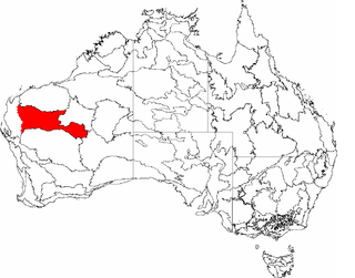
Gascoyne is an interim Australian bioregion located in Western Australia. It has an area of 180,752.57 square kilometres (69,788.96 sq mi). Together with Murchison bioregion to the south, it constitutes the Western Australian Mulga shrublands ecoregion, as assessed by the World Wildlife Fund.

<span class="mw-page-title-main">Hampton bioregion</span> Bioregion in Western Australia

Hampton is an interim Australian bioregion located in southeastern coastal Western Australia, with a small portion (4%) extending into adjacent South Australia. It has an area of 1,088,198 hectares. The Hampton bioregion is part of the Coolgardie woodlands ecoregion.

<span class="mw-page-title-main">Yalgoo bioregion</span> Bioregion in Western Australia

Yalgoo is an interim Australian bioregion located in Western Australia. It has an area of 5,087,577 hectares. The bioregion, together with the Avon Wheatbelt and Geraldton Sandplains bioregions, is part of the larger Southwest Australia savanna ecoregion as classified by the World Wildlife Fund.

<span class="mw-page-title-main">Geography of Western Australia</span>

Western Australia occupies nearly one third of the Australian continent. Due to the size and the isolation of the state, considerable emphasis has been made of these features; it is the second largest administrative territory in the world, after Yakutia in Russia, despite the fact that Australia is only the sixth largest country in the world by area, and no other regional administrative jurisdiction in the world occupies such a high percentage of a continental land mass. It is also the only first level administrative subdivision to occupy the entire continental coastline in one cardinal direction.

<span class="mw-page-title-main">Coolgardie woodlands</span> Terrestrial ecoregion in Western Australia

The Coolgardie woodlands is an ecoregion in southern Western Australia. The predominant vegetation is woodlands and mallee scrub. The ecoregion is a transitional zone between the Mediterranean-climate forests, woodlands, and shrublands of Southwest Australia and the deserts and dry scrublands of the Australian interior.

<span class="mw-page-title-main">Southwest Australia savanna</span> Terrestrial ecoregion in Western Australia

The Southwest Australia savanna is an ecoregion in Western Australia.

<span class="mw-page-title-main">Central Ranges xeric scrub</span> Deserts and xeric shrublands ecoregion of Australia

The Central Ranges xeric scrub is a deserts and xeric shrublands ecoregion of Australia.

<span class="mw-page-title-main">Tirari–Sturt stony desert</span>

The Tirari–Sturt stony desert is a deserts and xeric shrublands ecoregion in central Australia.

<span class="mw-page-title-main">Western Australian mulga shrublands</span> Terrestrial ecoregion in Western Australia

The Western Australian Mulga shrublands is a deserts and xeric shrublands ecoregion of inland Western Australia. It is one of Australia's two mulga ecoregions, characterized by dry woodlands of mulga trees interspersed with areas of grassland and scrub.

<i>Acacia arrecta</i> Species of legume

Acacia arrecta, commonly known as Yarnda Nyirra wattle or Fortescue wattle, is a shrub of the genus Acacia and the subgenus Plurinerves that is endemic to arid areas in north western Australia.

<span class="mw-page-title-main">Mulga (habitat)</span> Habitat dominated by the mulga tree

Mulga is a type of habitat composed of woodland or open forest dominated by the mulga tree, Acacia aneura, or similar species of Acacia.

<span class="mw-page-title-main">Gawler bioregion</span> Region in South Australia

Gawler is an interim Australian bioregion located in South Australia. It has an area of 12,002,883 hectares. Gawler bioregion is part of the Tirari–Sturt stony desert ecoregion.

References

  1. Eric Dinerstein, David Olson, et al. (2017). An Ecoregion-Based Approach to Protecting Half the Terrestrial Realm, BioScience, Volume 67, Issue 6, June 2017, Pages 534–545; Supplemental material 2 table S1b.
  2. "IBRA7: Pilbara Bioregion (PIL" (PDF). Retrieved 20 April 2018.
  3. "IBRA7: Pilbara subregions (PIL01-PIL04" (PDF). Retrieved 20 April 2018.
  4. "Map of Ecoregions 2017". Resolve. Retrieved August 20, 2021.
  5. 1 2 "Pilbara shrublands". Digital Observatory for Protected Areas. Retrieved 9 May 2022.
  6. "Pilbara shrublands". The Encyclopedia of Earth. Retrieved August 20, 2021.
  7. 1 2 Heterick, B.E., B. Durrant, and N.R. Gunawardene (2010). "The ant fauna of the Pilbara Bioregion, Western Australia". Records of the Western Australian Museum, Supplement 78: 157–167 (2010).
  8. 1 2 3 Kendrick, Peter (2001). "Pilbara 3 (PIL3 – Hamersley subregion)". in A Biodiversity Audit of Western Australia’s 53 Biogeographical Subregions in 2002, Department of Conservation and Land Management, Western Australia Government, October 2001.
  9. Kendrick, Peter (2001). "Pilbara 2 (PIL2 – Fortescue Plains subregion)". in A Biodiversity Audit of Western Australia’s 53 Biogeographical Subregions in 2002, Department of Conservation and Land Management, Western Australia Government, October 2001.
  10. "Pilbara Conservation Strategy". Department of Parks and Wildlife, Government of Western Australia. 2017.