
Mulga is a type of habitat composed of woodland or open forest dominated by the mulga tree, Acacia aneura , or similar species of Acacia . [1]
Mulga is a type of habitat composed of woodland or open forest dominated by the mulga tree, Acacia aneura , or similar species of Acacia . [1]
It is found across Australia, covering 20% of arid regions, [2] including much of southwestern Queensland, New South Wales, South Australia, and Western Australia. [3] [4]
The Mulga Lands are an interim Australian bioregion located in northwestern New South Wales and southwestern Queensland in eastern Australia consisting of dry sandy plains with low mulga woodlands and shrublands that are dominated by mulga. [5] The Western Australian mulga shrublands is a large dry World Wildlife Fund ecoregion of inland Western Australia. [6]

The vegetation type is associated with the extensive plains of the continent's interior and other arid regions with infrequent and irregular rainfall. Mulga country intersperses with other vegetation such as spinifex, dominated by low mounds of Triodia , and wattle scrub (Mimosaceae) or interrupted by granitic outcrops, salt lakes, and desert. The mulga itself is a mid-sized tree that is usually well-established in the open woodland, only occurring as young plants in disturbed areas, and is typically around 8 metres tall.
Stands of mulga trees are usually around the same age, eventually dying and replaced in a periodic regeneration cycle. The vegetation type is composed of these trees, shrubs such as saltbushes, poverty bushes, pea flowers, daisies and wattles with grasses at the understory. Large fields of annuals appear after rains, producing remarkable displays of colour against the usual grey-green of mulga country. [7]

Acacia aneura, commonly known as mulga, is a species of flowering plant in the family Fabaceae and is endemic to inland Australia. It is a variable shrub or small tree with flat, narrowly linear to elliptic phyllodes, cylindrical spikes of bright yellow flowers and more or less flat and straight, leathery pods.

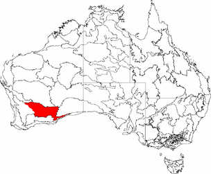
The Carnarvon xeric shrublands is a deserts and xeric shrublands ecoregion of Western Australia. The ecoregion is coterminous with the Carnarvon Interim Biogeographic Regionalisation for Australia (IBRA) bioregion.

Acacia kempeana, commonly known as wanderrie wattle, witchetty bush or granite wattle, is a shrub in subfamily Mimosoideae of family Fabaceae that is endemic to arid parts of central and western Australia.

Acacia ligulata is a species of Acacia, a dense shrub widespread in all states of mainland Australia. It is not considered rare or endangered. Its common names include sandhill wattle, umbrella bush, marpoo, dune wattle, small coobah, wirra, and watarrka.

The Murchison is a loosely defined area of Western Australia located within the interior of the Mid West region. It was the subject of a major gold rush in the 1890s and remains a significant mining district. The Murchison is also included as an interim Australian bioregion. The bioregion is loosely related to the catchment area of the Murchison River and has an area of 281,205 square kilometres (108,574 sq mi).
Mulga may refer to:
Coolgardie is an Australian bioregion consisting of an area of low hills and plains of infertile sandy soil in Western Australia. It has an area of 129,122.09 square kilometres (49,854.32 sq mi). It includes much of the Great Western Woodlands.

Hampton is an interim Australian bioregion located in southeastern coastal Western Australia, with a small portion (4%) extending into adjacent South Australia. It has an area of 1,088,198 hectares. The Hampton bioregion is part of the Coolgardie woodlands ecoregion.

Yalgoo is an interim Australian bioregion located in Western Australia. It has an area of 5,087,577 hectares. The bioregion, together with the Avon Wheatbelt and Geraldton Sandplains bioregions, is part of the larger Southwest Australia savanna ecoregion as classified by the World Wildlife Fund.

Western Australia occupies nearly one third of the Australian continent. Due to the size and the isolation of the state, considerable emphasis has been made of these features; it is the second largest administrative territory in the world, after Yakutia in Russia, despite the fact that Australia is only the sixth largest country in the world by area, and no other regional administrative jurisdiction in the world occupies such a high percentage of a continental land mass.

The Brigalow Belt is a wide band of acacia-wooded grassland that runs between tropical rainforest of the coast and the semi-arid interior of Queensland and northern New South Wales, Australia. The Interim Biogeographic Regionalisation for Australia (IBRA) divides the Brigalow Belt into two IBRA regions, or bioregions, Brigalow Belt North (BBN) and Brigalow Belt South (BBS). The North and South Brigalow Belt are two of the 85 bioregions across Australia and the 15 bioregions in Queensland. Together they form most of the Brigalow tropical savanna ecoregion.

The Paroo-Darling National Park is a protected national park that is located in the Far West region of New South Wales, in eastern Australia. The 178,053-hectare (439,980-acre) national park spans two distinct regions in the outback area. This region covers the arid catchments of the Paroo River and the Paroo-Darling confluence to the south.

The Mulga Lands are an interim Australian bioregion of eastern Australia consisting of dry sandy plains with low mulga woodlands and shrublands that are dominated by Acacia aneura (mulga). The Eastern Australia mulga shrublands ecoregion is coterminous with the Mulga Lands bioregion.

The Coolgardie woodlands is an ecoregion in southern Western Australia. The predominant vegetation is woodlands and mallee scrub. The ecoregion is a transitional zone between the Mediterranean-climate forests, woodlands, and shrublands of Southwest Australia and the deserts and dry scrublands of the Australian interior.
The Western Australian Mulga shrublands is a deserts and xeric shrublands ecoregion of inland Western Australia. It is one of Australia's two mulga ecoregions, characterized by dry woodlands of mulga trees interspersed with areas of grassland and scrub.

A thorn forest is a dense scrubland with vegetation characteristic of dry subtropical and warm temperate areas with a seasonal rainfall averaging 250 to 500 mm.

Acacia sibirica, commonly known as bastard mulga or false witchetty bush, is a tree or shrub belonging to the genus Acacia and the subgenus Juliflorae. It is native to arid areas of Australia.

The Mitchell Grass Downs is a tropical and subtropical grasslands, savannas, and shrublands ecoregion in northeastern Australia. It is a mostly treeless grassland, characterised by Mitchell grasses .

Gawler is an interim Australian bioregion located in South Australia. It has an area of 12,002,883 hectares. Gawler bioregion is part of the Tirari–Sturt stony desert ecoregion.