
The Interim Biogeographic Regionalisation for Australia (IBRA) is a biogeographic regionalisation of Australia developed by the Australian government's Department of Sustainability, Environment, Water, Population, and Communities. It was developed for use as a planning tool, for example for the establishment of a national reserve system. The first version of IBRA was developed in 1993–94 and published in 1995.

The Tanami Desert is a desert in northern Australia, situated in the Northern Territory and Western Australia.

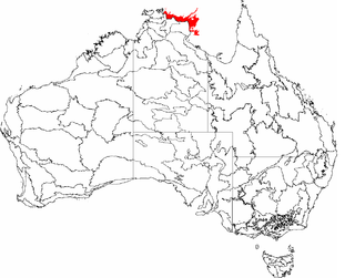
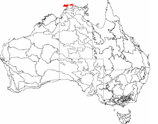
The Victoria Bonaparte, an interim Australian bioregion, is located in the Northern Territory and Western Australia, comprising 7,301,242 hectares.

Yalgoo is an interim Australian bioregion located in Western Australia. It has an area of 5,087,577 hectares. The bioregion, together with the Avon Wheatbelt and Geraldton Sandplains bioregions, is part of the larger Southwest Australia savanna ecoregion as classified by the World Wildlife Fund.

New England Tablelands, an interim Australian bioregion, is located mainly in New South Wales, comprising 3,002,213 hectares, of which 2,860,758 hectares or 95.23 per cent of the bioregion lies within New South Wales; and the residual within Queensland. This bioregion is one of the smaller bioregions in NSW, occupying 3.57 per cent of the state.
The Arnhem Coast, an interim Australian bioregion, is located in the Northern Territory, comprising an area of 3,335,669 hectares of the coastal plains that characterises central Arnhem Land in the Top End of the Northern Territory.

The Central Arnhem, an interim Australian bioregion, is located in the Northern Territory, comprising an area of 3,462,433 hectares of central Arnhem Land in the Top End of the Northern Territory.
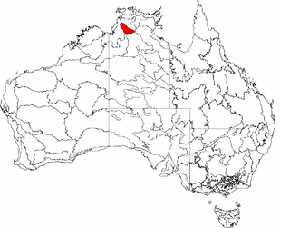
The Daly Basin, an interim Australian bioregion, is located in the Northern Territory, comprising an area of 2,092,229 hectares of central Arnhem Land in the Top End of the Northern Territory.

Nandewar, an interim Australian bioregion, is located in New South Wales and Queensland, and comprises an area of 2,701,977 hectares, surrounded by the Brigalow Belt South to the west, south-west and north-west, and to the east by the New England Tablelands. This is a region of hills on Palaeozoic sediments and lithosols and of Eucalyptus albens woodlands and summer rainfall.

The Pine Creek biogeographic region, an interim Australian bioregion, is located in the Northern Territory, and comprises 2,851,777 hectares.

The Gulf Coastal, an interim Australian bioregion, is located in the Northern Territory, comprising 2,711,718 hectares.

The Gulf Fall and Uplands, an interim Australian bioregion, is located in the Northern Territory and Queensland, comprising 11,847,909 hectares.

The Simpson Strzelecki Dunefields, an interim Australian bioregion, comprises 27,984,283 hectares, and is part of four state/territories of Australia: the Northern Territory, South Australia, New South Wales and Queensland

Finke, an interim Australian bioregion, comprises 7,267,416 hectares, and is part of two state/territories of Australia: the Northern Territory and South Australia. It is part of the Central Ranges xeric scrub ecoregion.

Stony Plains, an interim Australian bioregion, comprises 13,166,372 hectares, and is part of two state/territories of Australia: the Northern Territory and South Australia.
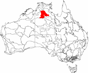
The Sturt Plateau, an interim Australian bioregion, is located in the Northern Territory, and covers an area of 9,857,531 hectares. The bioregion has the code STU. There are three subregions.

Tanami is an interim Australian bioregion, comprising 25,997,277 hectares in the Northern Territory and Western Australia. It is part of the Great Sandy-Tanami desert ecoregion.
Davenport Murchison Ranges is an interim Australian bioregion located in the Northern Territory. It has an area of 5,805,108 hectares. The bioregion is part of the larger Great Sandy-Tanami desert ecoregion.
Tiwi Cobourg is an interim Australian bioregion located in the Top End of the Northern Territory of Australia. It has an area of 1,010,580 hectares, which includes the Cobourg Peninsula of Arnhem Land, Croker Island, and the Tiwi Islands. The bioregion is part of the Arnhem Land tropical savanna ecoregion.

The South East Corner is an interim Australian bioregion located in eastern Victoria and south-eastern New South Wales. It has an area of 2,532,053 hectares. The South East Corner bioregion is part of the Southeast Australia temperate forests ecoregion, and it also features the Lowland Grassy Woodland.

