Yalgoo bioregion

Last updated

Yalgoo
Western Australia
EdelLandNationalPark.jpg
IBRA 6.1 Yalgoo.png
The interim Australian bioregions,
with Yalgoo in red
Area50,875.77 km2 (19,643.2 sq mi)
Localities around Yalgoo:
Shark Bay Carnarvon Murchison
Indian Ocean Yalgoo Murchison
Geraldton Sandplains Avon Wheatbelt Coolgardie

Yalgoo is an interim Australia bioregion located in Western Australia. [1] It has an area of 5,087,577 hectares (12,571,680 acres). [2] The bioregion, together with the Avon Wheatbelt and Geraldton Sandplains bioregions, is part of the larger Southwest Australia savanna ecoregion as classified by the World Wildlife Fund. [3]

Contents

Geography

The Yalgoo bioregion extends southeastwards from the southern end of Shark Bay on Australia's west coast nearly to Lake Barlee in the interior of Western Australia.

The western portion, known as the Edel subregion, includes the Edel Land peninsula and Dirk Hartog, Bernier, and Dorre islands, which enclose Shark Bay on the west. It also includes the coastal plain south of Shark Bay nearly to Kalbarri, where it transitions to the Geraldton Sandplains bioregion. The Edel subregion rests on the Carnarvon and Perth sedimentary basins. The Zuytdorp Cliffs line the coast from the northern end of Edel Land to the mouth of the Murchison River. Soils are generally white sands along the coast, and pale red quaternary sands further inland. [4]

The Tallering subregion includes the Toolonga Plateau, part of the Carnarvon basin, and extends southeastward across the Yilgarn Craton, an uplifted block of ancient crystalline rock. [5]

Subregions

In the Interim Biogeographic Regionalisation for Australia (IBRA) system it has the code of YAL, and it has two sub-regions.

IBRA regions and subregions: IBRA7
IBRA region / subregionIBRA codeArea States Location in Australia
YalgooYAL5,087,577 hectares (12,571,680 acres)WA IBRA 6.1 Yalgoo.png
Edel YAL011,588,634 hectares (3,925,600 acres)
Tallering YAL023,498,943 hectares (8,646,080 acres)

Earlier versions of the IBRA included the Edel subregion in the Geraldton Sandplains bioregion. 2004's version 6.1 of the IBRA added the Edel subregion to the Yalgoo bioregion, and re-designated the original Yalgoo bioregion as the Tallering subregion. [6]

Climate

The bioregion has a semi-arid Mediterranean climate, with hot, dry summers and mild winters. Most rainfall is in the winter months. Yalgoo bioregion is in the transitional region, or interzone, between the Mediterranean climate Southwest Australia and the deserts of central Australia. [4]

Flora and fauna

Common plant communities in the Edel subregion include tree-heaths dominated by members of the Proteaceae plant family, and AcaciaCasuarina thickets. [4] The vegetation of the Tallering subregion is characterised by woodlands, dominated by species of Eucalyptus, Acacia , and Callitris . Plant communities include CallitrisEucalyptus salubris woodlands, mulga ( Acacia aneura ) woodlands, and bowgada (Acacia ramulosa) open woodlands and scrub. The Tallering subregion is particularly rich in herbaceous ephemeral plants. [5]

Native mammals include the boodie (Bettongia lesueur), rufous hare-wallaby (Lagorchestes hirsutus), banded hare-wallaby (Lagostrophus fasciatus), western barred bandicoot (Perameles bougainville), and Shark Bay mouse (Pseudomys fieldi). [4] These mammals' current range is mostly limited to the Edel subregion, although some formerly had a wider range.

Native birds include the malleefowl (Leipoa ocellata) and western grasswren (Amytornis textilis). [4] A subspecies of purple-backed fairywren, Malurus assimilis bernieri, is found only on Bernier and Dorre islands, and the black and white fairy wren (Malurus leucopterus leucopterus), a subspecies of white-winged fairywren, is found only on Dirk Hartog Island.

The sandhill frog (Arenophryne rotunda) is a limited-range species found in the Edel subregion and the northern Geraldton Sandplains bioregion. [4]

Land use

The predominant land use is livestock pasturing on natural vegetation. [4] [5]

Protected areas

12.53% of the Yalgoo bioregion is in protected areas. [7]

Much of the Edel subregion is within the Shark Bay World Heritage area. [8] 32.28% of the subregion is protected, and protected areas include Shark Bay Marine Park, Dirk Hartog Island National Park, Zuytdorp Nature Reserve, and Toolonga Nature Reserve. [7]

Only 3.56 of the Tallering subregion is in protected areas. [7]

Related Research Articles

Shark Bay Bay of the Indian Ocean in Western Australia

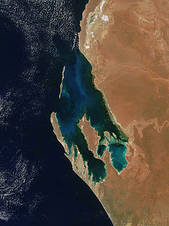
Shark Bay is a World Heritage Site in the Gascoyne region of Western Australia. The 23,000-square-kilometre (8,900 sq mi) area is located approximately 800 kilometres (500 mi) north of Perth, on the westernmost point of the Australian continent. UNESCO's official listing of Shark Bay as a World Heritage Site reads:

Carnarvon xeric shrublands Terrestrial ecoregion in Western Australia

The Carnarvon xeric shrublands is a deserts and xeric shrublands ecoregion of Western Australia. The ecoregion is coterminous with the Carnarvon Interim Biogeographic Regionalisation for Australia (IBRA) bioregion.

Southwest Australia Biogeographic region of Western Australia

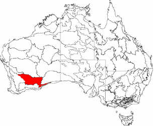
Southwest Australia is a biogeographic region in Western Australia. It includes the Mediterranean-climate area of southwestern Australia, which is home to a diverse and distinctive flora and fauna.

Murchison bioregion Bioregion in Western Australia

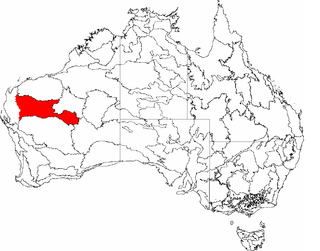
The Murchison is an interim Australian bioregion located within the Mid West of Western Australia. The bioregion is loosely related to the catchment area of the Murchison River and has an area of 281,205 square kilometres (108,574 sq mi). Traditionally the region is known as The Murchison.

Avon Wheatbelt Bioregion in Western Australia

The Avon Wheatbelt is a bioregion in Western Australia. It has an area of 9,517,104 hectares. It is considered part of the larger Southwest Australia savanna ecoregion.

Coolgardie bioregion Bioregion in Western Australia

Coolgardie is an Australian bioregion consisting of an area of low hills and plains of infertile sandy soil in Western Australia. It has an area of 129,122.09 square kilometres (49,854.32 sq mi). It includes much of the Great Western Woodlands.

Gascoyne bioregion Bioregion in Western Australia

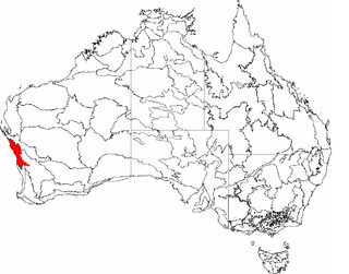
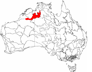
Gascoyne is an interim Australian bioregion located in Western Australia. It has an area of 180,752.57 square kilometres (69,788.96 sq mi). Together with Murchison bioregion to the south, it constitutes the Western Australian Mulga shrublands ecoregion, as assessed by the World Wildlife Fund.

Geraldton Sandplains Bioregion of Western Australia

Geraldton Sandplains is an interim Australian bioregion of Western Australia. It has an area of 3,142,149 hectares. The Geraldton Sandplains is part of the larger Southwest Australia savanna ecoregion, as assessed by the World Wildlife Fund.

Hampton bioregion Bioregion in Western Australia

Hampton is an interim Australian bioregion located in southeastern coastal Western Australia, with a small portion (4%) extending into adjacent South Australia. It has an area of 1,088,198 hectares. The Hampton bioregion is part of the Coolgardie woodlands ecoregion.

Northern Kimberley Bioregion in Western Australia

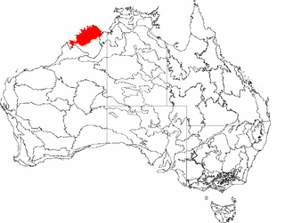
The Northern Kimberley, an interim Australian bioregion, is located in the northern Kimberley region of Western Australia, comprising 8,420,100 hectares.

Ord Victoria Plain Bioregion in Australia

The Ord Victoria Plain, an interim Australian bioregion, is located in the Northern Territory and Western Australia, comprising 12,540,703 hectares.

Central Western Shelf Province Marine bioregion in Western Australia

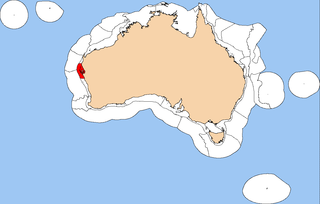
The Central Western Shelf Province, also known as the Shark Bay marine ecoregion, is a biogeographic region of Australia's continental shelf and coastal waters. It includes the subtropical coastal waters of Western Australia.

Brigalow Belt

The Brigalow Belt is a wide band of acacia-wooded grassland that runs between tropical rainforest of the coast and the semi-arid interior of Queensland, Australia. The Interim Biogeographic Regionalisation for Australia (IBRA) divides the Brigalow Belt into two IBRA regions, or bioregions, Brigalow Belt North (BBN) and Brigalow Belt South (BBS). The North and South Brigalow Belt are two of the 85 bioregions across Australia and the 15 bioregions in Queensland. Together they form most of the Brigalow tropical savanna ecoregion.

Eyre Yorke Block

The Eyre Yorke Block, also known as the Eyre and Yorke mallee, is an interim Australian (IBRA) bioregion and a World Wildlife Fund ecoregion covering part of the Eyre Peninsula and all of Yorke Peninsula as well as land to its immediate east in South Australia.

Southwest Australia savanna Terrestrial ecoregion in Western Australia

The Southwest Australia savanna is an ecoregion in Western Australia.

Western Australian mulga shrublands Terrestrial ecoregion in Western Australia

The Western Australian Mulga shrublands is a deserts and xeric shrublands ecoregion of inland Western Australia. It is one of Australia's two mulga ecoregions, characterized by dry woodlands of mulga trees interspersed with areas of grassland and scrub.

Burt Plain Ecoregion in the Northern Territory, Australia

Burt Plain, an interim Australian bioregion, is located in the Northern Territory, and comprises 7,379,719 hectares.

Central Mackay Coast Bioregion in Queensland, Australia

Central Mackay Coast, an interim Australian bioregion, is located in Queensland, and comprises 1,464,208 hectares.

Tanami bioregion Region in Australia

Tanami is an interim Australian bioregion, comprising 25,997,277 hectares in the Northern Territory and Western Australia. It is part of the Great Sandy-Tanami desert ecoregion.

Gawler bioregion Region in South Australia

Gawler is an interim Australian bioregion located in South Australia. It has an area of 12,002,883 hectares. Gawler bioregion is part of the Tirari–Sturt stony desert ecoregion.

References

  1. Environment Australia. "Revision of the Interim Biogeographic Regionalisation for Australia (IBRA) and Development of Version 5.1 – Summary Report" (PDF). Department of the Environment and Water Resources, Australian Government . Retrieved 15 May 2022.
  2. "Interim Biogeographic Regionalisation for Australia (IBRA7) regions and codes". Department of Sustainability, Environment, Water, Population and Communities. Commonwealth of Australia. 2012. Retrieved 13 January 2013.
  3. "Southwest Australia savanna". Terrestrial Ecoregions. World Wildlife Fund.
  4. 1 2 3 4 5 6 7 Desmond, Anthony, and Alanna Chant (2001). "Geraldton Sandplains 1 (GS1 - Edel subregion)" in A Biodiversity Audit of Western Australia’s 53 Biogeographical Subregions in 2002. Department of Conservation and Land Management, Government of Western Australia, November 2001.
  5. 1 2 3 Desmond, Anthony, and Alanna Chant (2001). "Geraldton Sandplains 1 (GS1 - Edel subregion)" in A Biodiversity Audit of Western Australia’s 53 Biogeographical Subregions in 2002. Department of Conservation and Land Management, Government of Western Australia, November 2001.
  6. Interim Biogeographic Regionalisation for Australia (IBRA) version 6.1, Department of Agriculture, Water and the Environment, 2004.
  7. 1 2 3 Lucinda Douglass, Carol Booth, Simon Kennedy, and Joel Turner (2019). An extraordinary natural legacy: An assessment and recommendations for the proposed expansion of Western Australia’s conservation reserve system. Commissioned by The Pew Charitable Trusts. Centre for Conservation Geography, March 2019.
  8. Shark Bay terrestrial reserves and proposed reserve additions: draft management plan: Bioregions and Figure 4: IBRA sub-regions of the Shark Bay Area (map). Department of Environment and Conservation; Conservation Commission of Western Australia. Bentley, W.A.: Dept. of Environment and Conservation. 2007. pp. 37–39.

Further reading