The Perth Basin is a thick, elongated sedimentary basin in Western Australia. It lies beneath the Swan Coastal Plain west of the Darling Scarp, representing the western limit of the much older Yilgarn Craton, and extends further west offshore. Cities and towns including Perth, Busselton, Bunbury, Mandurah and Geraldton are built over the Perth Basin.
The Perth Basin began forming in the Late Permian during the breakup of Gondwana, as the Australian continental plate began rifting away from the African and Indian continental plates.
During the Permian, what is now the Perth Basin was the eastern half of a rift valley that formed as the continental plates were pulled apart. This pulling apart, which continued until the Jurassic, led to the central zone subsiding as a graben allowing the sea to enter with the subsequent deposition of transgressive marine sediments. The Perth Basin architecture is dominated by listric, extensional faulting that formed during sedimentation and controlled the distribution of the sediments.
The primary mechanism for sedimentation was originally subsidence creating accommodation (space for sediments to accumulate), followed by fault extension and more recently, sediment loading, i.e. the basin continuing to subside because of the weight of sediments within it.
The eastern boundary of the main Perth Basin is the Darling Fault, topographically expressed as the Darling Scarp. Small outliers of the Perth Basin, such as the Collie Sub-basin, lie east of the Darling Fault.
Letters in brackets after the formation name represent shorthand symbols used on geological maps.
The Quaternary and recent sedimentation of the Perth Basin is represented by thin, impermanent sand dune systems, biogenic limestones, sandstones and some shales deposited during the last ~20 million years and during ice ages.
Cenozoic sand dune systems are locally being mined for mineral sands, mainly rutile (a source of titanium ) and zircon, by Iluka Resources and other companies.
Various formations from Cenozoic to Jurassic age are economically significant freshwater aquifers. Younger aquifers are an important suppliant to reservoir water in the city of Perth and elsewhere. The Yarragadee Formation, one of the thickest formations in the basin, is a very good aquifer in the southern part of the basin.
The Perth Basin contains Permian and Jurassic coal measures, the most important being mined primarily for electricity generation in the Collie Sub-basin at Collie in the south-west of the state.
The Perth Basin is also prospective for natural gas and oil, with recent exploration wells, including Origin Energy/Arc Energy's Hovea 2, confirming large resources of natural gas, but difficult reservoir geology and characteristics have prevented the full utilisation of these energy reserves. The oil is sourced from the Kockatea Shale.
Currently, a junior minerals exploration company is exploring the basin north of Perth for glauconite to produce potash fertilizer. [3]
Due to its shape and size, the basin has been surveyed and studied in distinctions such as offshore [4] and onshore, [5] north [6] south, [7] and central [8]

Greensand or green sand is a sand or sandstone which has a greenish color. This term is specifically applied to shallow marine sediment that contains noticeable quantities of rounded greenish grains. These grains are called glauconies and consist of a mixture of mixed-layer clay minerals, such as smectite and glauconite mica. Greensand is also loosely applied to any glauconitic sediment.

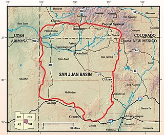
The San Juan Basin is a geologic structural basin located near the Four Corners region of the Southwestern United States. The basin covers 7,500 square miles and resides in northwestern New Mexico, southwestern Colorado, and parts of Utah and Arizona. Specifically, the basin occupies space in the San Juan, Rio Arriba, Sandoval, and McKinley counties in New Mexico, and La Plata and Archuleta counties in Colorado. The basin extends roughly 100 miles (160 km) N-S and 90 miles (140 km) E-W.
The Yarragadee Aquifer is a significant freshwater aquifer located in the south west of Western Australia and predominantly beneath the Swan Coastal Plain west of the Darling Scarp. It has a north–south range from about Geraldton to the south coast, but with a split in the formation south of Perth, Western Australia. The southern part is known as the South West Yarragadee Aquifer.

The Dakota is a sedimentary geologic unit name of formation and group rank in Midwestern North America. The Dakota units are generally composed of sandstones, mudstones, clays, and shales deposited in the Mid-Cretaceous opening of the Western Interior Seaway. The usage of the name Dakota for this particular Albian-Cenomanian strata is exceptionally widespread; from British Columbia and Alberta to Montana and Wisconsin to Colorado and Kansas to Utah and Arizona. It is famous for producing massive colorful rock formations in the Rocky Mountains and the Great Plains of the United States, and for preserving both dinosaur footprints and early deciduous tree leaves.

The geology of Kansas encompasses the geologic history and the presently exposed rock and soil. Rock that crops out in the US state of Kansas was formed during the Phanerozoic eon, which consists of three geologic eras: the Paleozoic, Mesozoic and Cenozoic. Paleozoic rocks at the surface in Kansas are primarily from the Mississippian, Pennsylvanian, and Permian periods.

The Nikanassin Formation is a stratigraphic unit of Late Jurassic (Portlandian) to Early Cretaceous (Barremian) age. It is present along the western edge of the Western Canada Sedimentary Basin in western Alberta and northeastern British Columbia. Its name was first proposed by D.B. Dowling in 1909 (Coal Fields South of Grand Trunk Pacific Railway, in the foothills of the Rocky Mountain, Alberta Page 140 paragraph 4 " to this it is proposed to give the name Nikanassin, from the Cree word meaning outer range" Also it is noted on the map by D.B. Dowling.(Geological Survey of Canada. Incorrect info follows: It was named by B.R. MacKay in 1929 for the Nikanassin Range of the front-central ranges of the Canadian Rockies. Mackay did not designate a type locality for the formation, although he described outcrops near the hamlet of Brûlé, north of the Yellowhead Highway outside of Jasper National Park.
Bullhead Group is a stratigraphic unit of Lower Cretaceous age in the Western Canada Sedimentary Basin of northeastern British Columbia and western Alberta. It was first defined by F.H. McLearn in 1918 as the Bullhead Mountain Formation, but later was upgraded to group status. It consists of the Cadomin and Gething Formations, although some early workers included the Bluesky Formation and others in the group.

The Fernie Formation is a stratigraphic unit of Jurassic age. It is present in the western part of the Western Canada Sedimentary Basin in western Alberta and northeastern British Columbia. It takes its name from the town of Fernie, British Columbia, and was first defined by W.W. Leach in 1914.

The Lower Greensand Group is a geological unit present across large areas of Southern England. It was deposited during the Aptian and Albian stages of the Early Cretaceous. It predominantly consists of sandstone and unconsolidated sand that were deposited in shallow marine conditions.
Geologically the Australian state of New South Wales consists of seven main regions: Lachlan Fold Belt, the Hunter-Bowen Orogeny or New England Orogen (NEO), the Delamerian Orogeny, the Clarence Moreton Basin, the Great Artesian Basin, the Sydney Basin, and the Murray Basin.
The Zonguldak basin of northwestern Turkey is the only basin in Turkey with mineable coal deposits. It has been mined for coal since the late 1800s. The basin takes its name after Zonguldak, Turkey, and lies at approximately 41° N. It is roughly elliptical in shape with its long axis oriented roughly southwest to northeast, and is adjacent to the Black Sea. Three main regions have been recognized in the Zonguldak basin: from west to east, Armutcuk, Zonguldak, and Amasra.
The Thermopolis Shale is a geologic formation which formed in west-central North America in the Albian age of the Late Cretaceous period. Surface outcroppings occur in central Canada, and the U.S. states of Montana and Wyoming. The rock formation was laid down over about 7 million years by sediment flowing into the Western Interior Seaway. The formation's boundaries and members are not well-defined by geologists, which has led to different definitions of the formation. Some geologists conclude the formation should not have a designation independent of the formations above and below it. A range of invertebrate and small and large vertebrate fossils and coprolites are found in the formation.
The Monteith Formation is a geologic formation of Early Cretaceous (Valanginian) age in the Western Canada Sedimentary Basin that consists primarily of sandstone. It is present in the northern foothills of the Canadian Rockies and the adjacent plains in northeastern British Columbia and west-central Alberta.
The geology of West Sussex in southeast England comprises a succession of sedimentary rocks of Cretaceous age overlain in the south by sediments of Palaeogene age. The sequence of strata from both periods consists of a variety of sandstones, mudstones, siltstones and limestones. These sediments were deposited within the Hampshire and Weald basins. Erosion subsequent to large scale but gentle folding associated with the Alpine Orogeny has resulted in the present outcrop pattern across the county, dominated by the north facing chalk scarp of the South Downs. The bedrock is overlain by a suite of Quaternary deposits of varied origin. Parts of both the bedrock and these superficial deposits have been worked for a variety of minerals for use in construction, industry and agriculture.
The Cattamarra Coal Measures is an Early Jurassic geological unit in Western Australia.

The Exmouth Plateau is an elongate northeast striking extensional passive margin located in the Indian Ocean roughly 3,000 meters offshore from western and northwestern Western Australia.
The Bickford Formation is a geologic formation of Early Cretaceous (Valanginian) age in the Western Canada Sedimentary Basin that consists primarily of nonmarine sediments. It is present in the northern foothills of the Canadian Rockies in northeastern British Columbia.
The geology of Western Sahara includes rock units dating back to the Archean more than two billion years old, although deposits of phosphorus formed in the Mesozoic and Cenozoic have helped to prompt the current Moroccan occupation of most of the country.
The geology of Morocco formed beginning up to two billion years ago, in the Paleoproterozoic and potentially even earlier. It was affected by the Pan-African orogeny, although the later Hercynian orogeny produced fewer changes and left the Maseta Domain, a large area of remnant Paleozoic massifs. During the Paleozoic, extensive sedimentary deposits preserved marine fossils. Throughout the Mesozoic, the rifting apart of Pangaea to form the Atlantic Ocean created basins and fault blocks, which were blanketed in terrestrial and marine sediments—particularly as a major marine transgression flooded much of the region. In the Cenozoic, a microcontinent covered in sedimentary rocks from the Triassic and Cretaceous collided with northern Morocco, forming the Rif region. Morocco has extensive phosphate and salt reserves, as well as resources such as lead, zinc, copper and silver.
The geology of Afghanistan includes nearly one billion year old rocks from the Precambrian. The region experienced widespread marine transgressions and deposition during the Paleozoic and Mesozoic, that continued into the Cenozoic with the uplift of the Hindu Kush mountains.