
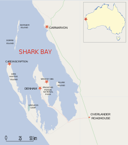
Dirk Hartog Island is an island off the Gascoyne coast of Western Australia, within the Shark Bay World Heritage Area. It is about 80 kilometres long and between 3 and 15 kilometres wide and is Western Australia's largest and westernmost island. It covers an area of 620 square kilometres and is approximately 850 kilometres north of Perth.

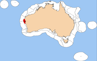
Shark Bay is a World Heritage Site in the Gascoyne region of Western Australia. The 23,000-square-kilometre (8,900 sq mi) area is located approximately 800 kilometres (500 mi) north of Perth, on the westernmost point of the Australian continent.

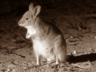
The banded hare-wallaby, mernine, or munning is a marsupial currently found on the islands of Bernier and Dorre off western Australia. Reintroduced populations have recently been established on islands and fenced mainland sites, including Faure Island and Wadderin Sanctuary near Narembeen in the central wheatbelt.

The Shark Bay Marine Park is a protected marine park located within the UNESCO World Heritage–listed Shark Bay, in the Gascoyne region of Western Australia. The 748,725-hectare (1,850,140-acre) marine park is situated over 800 kilometres (500 mi) north of Perth and 400 kilometres (250 mi) north of Geraldton.

Threatened fauna of Australia are those species and subspecies of birds, fish, frogs, insects, mammals, molluscs, crustaceans, and reptiles to be found in Australia that are in danger of becoming extinct. This article lists species classified as threatened species under the Commonwealth Environment Protection and Biodiversity Conservation Act 1999.

Hartog Plate or Dirk Hartog's Plate is either of two pewter plates, although primarily the first, which were left on Dirk Hartog Island on the western coast of Australia before European settlement there. The first plate, left in 1616 by Dutch explorer Dirk Hartog, is the oldest-known artefact of European exploration in Australia still in existence. A replacement, which includes the text of the original and some new text, was left in 1697; the original dish was returned to the Netherlands, where it is now on display in the Rijksmuseum. Further additions at the site, in 1801 and 1818, led to the location being named Cape Inscription.

The boodie, also known as the burrowing bettong or Lesueur's rat-kangaroo, is a small, furry, rat-like mammal native to Australia. Once common throughout the continent, it is now restricted to a few coastal islands. A member of the rat-kangaroo family (Potoroidae), it lives in burrows and is active at night when it forages for fungi, roots, and other plant matter. It is about the size of a rabbit and, like most marsupials, carries its young in a pouch.

The Western barred bandicoot, also known as the Shark Bay bandicoot or the Marl, is a small species of bandicoot; now extinct across most of its former range, the western barred bandicoot only survives on offshore islands and in fenced sanctuaries on the mainland.
The rufous hare-wallaby, also known as the mala, is a small macropod found in Australia. It was formerly widely distributed across the western half of the continent, but naturally occurring populations are now confined to Bernier Island and Dorre Island Islands off Western Australia.
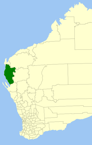
The Shire of Carnarvon is a local government area in the Gascoyne region of Western Australia, located about 900 kilometres (560 mi) north of the state capital, Perth. The Shire covers an area of 46,664 square kilometres (18,017 sq mi), and its seat of government is the town of Carnarvon. The major industries in the area are wool, agriculture and, more recently, tourism.

Yalgoo is an interim Australian bioregion located in Western Australia. It has an area of 5,087,577 hectares. The bioregion, together with the Avon Wheatbelt and Geraldton Sandplains bioregions, is part of the larger Southwest Australia savanna ecoregion as classified by the World Wildlife Fund.

Faure Island is a 58 km2 island pastoral lease and nature reserve, east of the Francois Peron National Park on the Peron Peninsula, in Shark Bay, Western Australia. It lies in line with the Monkey Mia resort to the west, and the Wooramel River on the eastern shore of Shark Bay. It is surrounded by the Shark Bay Marine Park and Shark Bay World Heritage Site and, as the Faure Island Sanctuary, is owned and managed by the Australian Wildlife Conservancy (AWC).
The Central Western Shelf Province, also known as the Shark Bay marine ecoregion, is a biogeographic region of Australia's continental shelf and coastal waters. It includes the subtropical coastal waters of Western Australia.
Western Australia has the longest coastline of any state or territory in Australia, at 10,194 km or 12,889 km. It is a significant portion of the coastline of Australia, which is 35,877 km.
Bernier Island is one of three islands that comprise the Bernier and Dorre Island Nature Reserve in the Shark Bay World Heritage area in Western Australia.
Peron Peninsula is a long narrow peninsula located in the Shark Bay World Heritage site in Western Australia, at about 25°51′S113°30′E. It is some 130 kilometres (81 mi) long, running north-northwesterly, located east of Henri Freycinet Harbour and west of Havre Hamelin and Faure Island. It is the largest of the Shark Bay peninsulas. Significant settlements include Denham and Monkey Mia. Shark Bay Airport is located there. It is the location of former Pastoral leases Peron and Nanga stations, and is the main location of land access to points within the World Heritage site. The northern area contains the Francois Peron National Park. It is surrounded by the Shark Bay Marine Park and its lower southeast part is adjacent to the Hamelin Pool Marine Nature Reserve.
The Geographe Channel is an arm of the Indian Ocean between Bernier Island and Dorre Island and the mainland of Western Australia. It is the northern part of Shark Bay.
Heirisson Prong is a community managed reserve established for the conservation of threatened mammals at Shark Bay in Western Australia. The reserve is at the point of a long narrow peninsula of the same name that juts into Shark Bay from the south.
Crenadactylus occidentalis, also called the western clawless gecko, is a species of gecko endemic to the western coast of Australia.
The Bernier and Dorre Island lock hospitals were two lock hospitals set up on Bernier and Dorre Islands from 1908 to 1919. Only Aboriginal people suspected of having a venereal disease were incarcerated. The conditions inmates were put under was inhumane and resulted in more than 40% not returning to their homelands.
