States and territories of Australia

Last updated

States and territories of Australia
Australia states and territories labelled.svg
Location Australia
Number 16 (6 states, 3 internal territories, and 7 external territories)
PopulationsSmallest state:
Largest state:
Smallest territories:Largest territory:
AreasSmallest state:
Largest state:
Smallest territory:
Largest territories:
Subdivisions

The states and territories are the second level of government of Australia. The states are administrative divisions that are self-governing polities that are partly sovereign, having ceded some sovereign rights to the federal government. [1] They have their own constitutions, legislatures, executive governments, judiciaries and law enforcement agencies that administer and deliver public policies and programs. Territories can be autonomous and administer local policies and programs much like the states in practice, but are still legally subordinate to the federal government.

Contents

Australia has six federated states (New South Wales, Queensland, South Australia, Tasmania (including Macquarie Island), Victoria, and Western Australia) and ten federal territories, [2] out of which three are internal territories (the Australian Capital Territory, the Jervis Bay Territory, and the Northern Territory) [2] on the Australian mainland and seven are external territories (Ashmore and Cartier Islands, the Australian Antarctic Territory, [lower-alpha 1] Christmas Island, the Cocos (Keeling) Islands, the Coral Sea Islands, Heard Island and McDonald Islands, and Norfolk Island) [2] that are offshore dependent territories. Every state and internal territory (except the Jervis Bay Territory) is self-governing with its own independent executive government, legislative branch, and judicial system, while the rest only have local government status overseen by federal departments.

State and territory governments may legislate on matters concerning their citizens, subject to the limits of the federal constitution (notably section 51 and section 109). Each state and internal territory (except Jervis Bay Territory) has its own legislature, although the Federal Parliament can override territorial legislation. The federal High Court of Australia acts as a final court of appeal for all matters, and has the authority to override any state judiciary. While all states and internal territories have their own judicial system (subject to appeal to the High Court), most external territories are subject to the judiciary and legislature of either a state or internal territory. Excluding the Heard Island and McDonald Islands and the Australian Antarctic Territory (which are governed by the Department of Climate Change, Energy, the Environment and Water), the external territories are governed by the federal Department of Infrastructure, Transport, Regional Development, Communications and the Arts. [3] Norfolk Island had its own legislature from 1979 to 2015. [4]

Each state is a successor to historical British colonies, and each has its own constitution. The Australian Capital Territory (ACT) and Northern Territory for the most part operate indistinguishably from the states, even though they do not have constitutional status as states and territorial legislation can be overridden.

Geography

Surrounded by the Indian, Pacific, and Southern oceans, Australia is separated from Maritime Southeast Asia and New Guinea by the Arafura Sea, the Timor Sea, and the Torres Strait, from Island Melanesia by the Coral Sea, and from New Zealand by the Tasman Sea. The world's smallest continent, Australia is also the sixth-largest country by land area and sometimes considered the world's largest island. Australia has a mainland coastline of 32,994 kilometres (20,502 mi) [5] and claims an exclusive economic zone of about 8,200,000 square kilometres (3,200,000 sq mi). [6]

Borders

States and territories

Aus Population - States.png

At Federation in 1901, what is now the Northern Territory was within South Australia, what are now the Australian Capital Territory and Jervis Bay Territory were within New South Wales, and Coral Sea Islands was part of Queensland. Ashmore and Cartier Islands was accepted by Australia in 1934 [7] and was annexed to the Northern Territory prior to adoption of the Statute of Westminster in 1942, deemed effective from 1939; it has thus become part of Australia.

States

States of Australia [lower-alpha 2]
Flag StatePostal ISO [8] Capital Population
(June 2023) [9]
Area (km2) [10] Population Density (/km2)No. of Reps. in Aus House [11] Governor Premier
(Party)
State Government
Flag of New South Wales.svg New South Wales NSWAU-NSW Sydney 8,339,347800,15010.2447 Margaret Beazley Chris Minns (Labor) Government of New South Wales
Flag of Victoria (Australia).svg Victoria VICAU-VIC Melbourne 6,812,477227,41628.4738 Margaret Gardner Jacinta Allan
(Labor)
Victorian Government
Flag of Queensland.svg Queensland QLDAU-QLD Brisbane 5,459,4131,729,7422.9330 Jeannette Young Steven Miles
(Labor)
Queensland Government
Flag of Western Australia.svg Western Australia WAAU-WA Perth [lower-alpha 3] 2,527,0132,527,0131.0816 Chris Dawson Roger Cook
(Labor)
Government of Western Australia
Flag of South Australia.svg South Australia SAAU-SA Adelaide 1,851,704984,3211.7710 Frances Adamson Peter Malinauskas (Labor) Government of South Australia
Flag of Tasmania.svg Tasmania TASAU-TAS Hobart 572,78064,5196.315 Barbara Baker Jeremy Rockliff
(Liberal)
Tasmanian Government

Territories

Internal territories

Internal territories of Australia [lower-alpha 4]
Flag TerritoryPostal ISO [8] Capital
(or largest settlement)
Population
(June 2023) [9]
Area (km2) [10] Population Density (/km2)No. of Reps. in Aus House [11] Administrator Chief Minister
(Party)
Territory Government
Flag of the Australian Capital Territory.svg Australian Capital Territory ACTAU-ACT Canberra 466,8132,3581923None [lower-alpha 5] Andrew Barr
(Labor)
ACT Government
Flag of the Northern Territory.svg Northern Territory NTAU-NT Darwin 252,4731,347,7910.182 Hugh Heggie Eva Lawler
(Labor)
Northern Territory Government
Flag of Australia (converted).svg Jervis Bay Territory NSWNone
(Jervis Bay Village)
405676.04(Part of Division of Fenner)None [lower-alpha 6] None

External territories

External territories of Australia [lower-alpha 7]
Flag TerritoryPostal ISO [8] Capital
(or largest settlement)
Population
(Jun 2018) [9]
Area (km2) [10] Population Density (/km2)Seats in House of Representatives Administrator Shire President or Mayor
Flag of Norfolk Island.svg Norfolk Island NSWNF Kingston 2,6013574(Part of Division of Bean)George Plant Robin Adams (mayor) [12]
Flag of Christmas Island.svg Christmas Island WACX Flying Fish Cove 1,93813514(Part of Division of Lingiari) Farzian Zainal Gordon Thompson
Flag of the Cocos (Keeling) Islands.svg Cocos (Keeling) Islands WACC West Island 5471439(Part of Division of Lingiari) Farzian Zainal Aindil Minkom [13]
Flag of Australia (converted).svg Australian Antarctic Territory TASAQ [lower-alpha 8] None
(Davis Station)
60 [lower-alpha 9] 5,896,5000.0000102NoneNone
Flag of Australia (converted).svg Coral Sea Islands None
(Willis Island)
4 [lower-alpha 10] 780,000 [lower-alpha 11] 0.000005NoneNone
Flag of Australia (converted).svg Ashmore and Cartier Islands None
(offshore anchorage)
01990NoneNone
Flag of Australia (converted).svg Heard Island and McDonald Islands TASHMNone
(Atlas Cove)
03720NoneNone

Each external territory is regulated by an Act of the federal Parliament. These Acts contain the majority of provisions determining the legal and political structure applying in that external territory. Under s 122 of the Australian Constitution the federal Parliament has plenary power to make laws for all territories including all external territories. [15]

The Cocos (Keeling) Islands voted for integration in 1984. Together with Christmas Island, these two territories comprise the Australian Indian Ocean Territories. Commonwealth laws apply automatically to the territories unless expressly stated otherwise [16] and residents of both external territories are associated with Northern Territory for federal elections. They are, thus, constitutionally part of Australia.

The Heard Island and McDonald Islands, although uninhabited, are treated as constitutionally part of Australia by the central government. [17]

Norfolk Island's status is controversial, with the present (as of 2018) government taking measures to integrate the territory into Australia proper (including representation in parliament and compulsory voting). The Norfolk Islanders have not formally consented to this change in constitutional status and assert that they are not Australian. [4]

Integration of territories with small populations
TerritoryRef.Subject to laws ofSubject to courts ofPart of electorate of
for House for Senate
Christmas Island [18] Western Australia [a] Division of Lingiari Northern Territory
Cocos (Keeling) Islands [19]
Jervis Bay Territory [20] Australian Capital Territory [a] Division of Fenner Australian Capital Territory
Norfolk Island [21]
[22]
[23]
Norfolk Island [b]
New South Wales [a]
Queensland [a]
Norfolk Island Division of Bean
Ashmore and Cartier Islands [24] Northern Territory (no permanent population)
Australian Antarctic Territory [25] Australian Capital Territory
Heard Island and McDonald Islands [26]
Coral Sea Islands [27] [28] Australian Capital Territory Norfolk Island
Notes
  1. ^
    a) Residents of the territory are not represented in the parliament or assembly that makes these laws, or in the government that appoints judges to these courts.
  2. ^
    b) Laws passed by the Norfolk Island Legislative Assembly while it existed from 1979 to 2015 remain in effect unless modified or repealed by the federal government. [29]

Former territories

Internal

Two internal territories established by the Australian federal government under Section 122 of the Constitution of Australia no longer exist:

External

Two present-day Oceanic countries, Papua New Guinea (PNG) and Nauru, were administered by the federal government of Australia as de facto or de jure external territories for differing periods between 1902 and 1975.

Papua and New Guinea (1883–1949)

Following World War II, the Papua and New Guinea Act 1949 placed the Territory of New Guinea in an "administrative union" with the Territory of Papua, and the combined Territory of Papua and New Guinea was created. However, both territories remained technically distinct for some administrative and legal purposes, until 1975, when the combined entity eventually was given independence as Papua New Guinea.

Nauru (1920–1968)

Nauru was previously under the German colonial empire as part of the German New Guinea. Following World War I, the Australian government received a League of Nations mandate for Nauru. After World War II, the Territory of Papua, Territory of New Guinea and Nauru were all controlled by the Australian government as United Nations trust territories. Nauru was granted independence in 1968.

Statistics

The majority of Australians live in the eastern coastal mainland states of New South Wales, Queensland, Victoria, and the Australian Capital Territory, which collectively forms 79% of the entire population of Australia (more than three-quarters of all Australians). Most of the major population centres are located east and south of the Great Dividing Range on the coastal plains and their associated hinterland regions.

State / territoryAbbreviationLand area [10]
Population density
  • % of population
  • in capital
Notes
km2sq miRankNumberRank/km2/sq miRank %Rank
Flag of New South Wales.svg  New South Wales NSW801,150309,33058,072,16319.6224.9363.0%5 [31]
Flag of Victoria (Australia).svg  Victoria VIC227,44487,81766,503,491226.5668.8271.0%4 [32]
Flag of Queensland.svg  Queensland QLD1,729,742667,85725,156,13832.797.2546.0%7 [33]
Flag of Western Australia.svg  Western Australia WA2,527,013975,68512,660,02641.032.7773.4%3 [34]
Flag of South Australia.svg  South Australia SA984,321380,04841,781,51651.744.5673.5%2 [35]
Flag of Tasmania.svg  Tasmania TAS68,40126,4107557,57167.5819.6441.0%8 [36]
Flag of the Australian Capital Territory.svg  Australian Capital Territory ACT2,3589108453,8907167.6434199.6%1 [37]
Flag of the Northern Territory.svg  Northern Territory NT1,347,791520,3853232,60580.180.47854.0%6 [38]

Statistical divisions

The Australian Bureau of Statistics' (ABS) Australian Statistical Geography Standard describes several main statistical divisions of Australia:

The ABS also defines other divisions such as the Greater Capital City Statistical Area Structure, Significant Urban Area Structure, Remoteness Structure, and Indigenous Structure. Other non-ABS divisions include Local Government Areas, Postal Areas, electoral divisions, and tourism regions. [39]

Background and overview

Australia history.gif

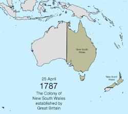
The states originated as separate British colonies prior to Federation in 1901. The Colony of New South Wales was founded in 1788 and originally comprised much of the Australian mainland, as well as Lord Howe Island, New Zealand, Norfolk Island, and Van Diemen's Land, in addition to the area currently referred to as the state of New South Wales. During the 19th century, large areas were successively separated to form the Colony of Tasmania (initially established as a separate colony named Van Diemen's Land in 1825), the Colony of Western Australia (initially established as the smaller Swan River Colony in 1829), the Province of South Australia (1836), the Colony of New Zealand (1840), [40] the Victoria Colony (1851) and the Colony of Queensland (1859). Upon federation, the six colonies of New South Wales, Victoria, Queensland, South Australia, Western Australia, and Tasmania became the founding states of the new Commonwealth of Australia.

The legislative powers of the states are protected by the Australian constitution, section 107, and under the principle of federalism, Commonwealth legislation only applies to the states where permitted by the constitution. The territories, by contrast, are from a constitutional perspective directly subject to the Commonwealth government; laws for territories are determined by the Australian Parliament. [41]

Most of the territories are directly administered by the Commonwealth government, while two (the Northern Territory and the Australian Capital Territory) have some degree of self-government although less than that of the states. In the self-governing territories, the Australian Parliament retains the full power to legislate, and can override laws made by the territorial institutions, which it has done on rare occasions. For the purposes of Australian (and joint Australia-New Zealand) intergovernmental bodies, the Northern Territory and the Australian Capital Territory are treated as if they were states.

Each state has a governor, appointed by the monarch (currently King Charles III), which by convention he does on the advice of the state premier. The Administrator of the Northern Territory, by contrast, is appointed by the governor-general. The Australian Capital Territory has neither a governor nor an administrator, but the governor-general exercises some powers that in other jurisdictions are exercised by the governor of a state or administrator of a territory, such as the power to dissolve the Legislative Assembly.

Jervis Bay Territory is the only non-self-governing internal territory. Until 1989, it was administered as if it were a part of the ACT, although it has always been a separate territory. Under the terms of the Jervis Bay Territory Acceptance Act 1915, [42] the laws of the ACT apply to the Jervis Bay Territory insofar as they are applicable and providing they are not inconsistent with an ordinance. [43] Although residents of the Jervis Bay Territory are generally subject to laws made by the ACT Legislative Assembly, they are not represented in the assembly. They are represented in the Parliament of Australia as part of the Electoral Division of Fenner (named the Division of Fraser until 2016) in the ACT and by the ACT's two senators. In other respects, the territory is administered directly by the Federal Government through the Territories portfolio. [44]

The external territory of Norfolk Island possessed a degree of self-government from 1979 until 2015.

Each state has a bicameral parliament, except Queensland, which abolished its upper house in 1922. The lower house is called the "legislative assembly", except in South Australia and Tasmania, where it is called the "house of assembly". Tasmania is the only state to use proportional representation for elections to its lower house; all others elect members from single member constituencies, using preferential voting. The upper house is called the "legislative council" and is generally elected from multi-member constituencies using proportional representation. The three self-governing territories, the ACT, the Northern Territory, and Norfolk Island, each have unicameral legislative assemblies.

The head of government of each state is called the "premier", appointed by the state's governor. In normal circumstances, the governor will appoint as premier whoever leads the party or coalition which exercises control of the lower house (in the case of Queensland, the only house) of the state parliament. However, in times of constitutional crisis, the governor can appoint someone else as premier. The head of government of the self-governing internal territories is called the "chief minister". The Northern Territory's chief minister, in normal circumstances whoever controls the legislative assembly, is appointed by the administrator.

The term interstate is used within Australia to refer to a number of events, transactions, registrations, travel, etc. which occurs across borders or outside of the particular state or territory of the user of the term. Examples of use include motor vehicle registration, [45] travel, [46] applications to educational institutions out of one's home state. [47]

There are very few urban areas bifurcated by state or territory borders. The Queensland-New South Wales border runs through Coolangatta (Queensland) and Tweed Heads (New South Wales) and splits Gold Coast Airport. Oaks Estate, a contiguous residential of Queanbeyan, was excised out of New South Wales when the Australian Capital Territory was established in 1909. Some Urban Centres and Localities reported by the Australian Bureau of Statistics include some agglomerations of cities spreading across state borders, including Gold Coast–Tweed Heads, Canberra–Queanbeyan, AlburyWodonga (New South Wales-Victoria) and MilduraWentworth (Victoria-New South Wales)

Timeline

Comparative terminology

EntityType of entityTie to the monarchDomestic administratorHead of governmentUpper House of ParliamentLower House of ParliamentMember of Parliament
Upper houseLower house [note 1]
Commonwealth of Australia Federal governmentDirectGovernor-generalPrime ministerSenateHouse of RepresentativesSenatorMP
South Australia Federated state Direct (established by the Australia Act 1986 )GovernorPremierLegislative CouncilHouse of AssemblyMLCMHA
Tasmania
New South Wales Legislative AssemblyMP
Victoria MLA
Western Australia
Queensland N/A (abolished 1922)MP
Australian Capital Territory Self-governing territoryIndirect (through the governor-general acting as "administrator")Assembly and chief ministerChief ministerMLA
Northern Territory Indirect (through the governor-general)Administrator
Christmas Island External territoryShire presidentShire CouncilCouncillor
Cocos (Keeling) Islands
Norfolk Island MayorRegional Council [note 2]
Note:
  1. The abbreviation MP is an acceptable, and indeed more common, term for members of each lower house.
  2. Between 1979 and 2015 Norfolk Island was a self-governing external territory with its own legislature, the Norfolk Island Legislative Assembly, until this was abolished by the Commonwealth Parliament.

Politics

Map showing the jurisdictions of Australia and their governing political parties as of March 2023.
.mw-parser-output .legend{page-break-inside:avoid;break-inside:avoid-column}.mw-parser-output .legend-color{display:inline-block;min-width:1.25em;height:1.25em;line-height:1.25;margin:1px 0;text-align:center;border:1px solid black;background-color:transparent;color:black}.mw-parser-output .legend-text{}
Labor
Liberal States of Australia (governing political parties).svg
Map showing the jurisdictions of Australia and their governing political parties as of March 2023.
  Labor
  Liberal

Governors and administrators

PostIncumbentAppointed
Governor of New South Wales Margaret Beazley 2 May 2019
Governor of Victoria Margaret Gardner 9 August 2023
Governor of Queensland Jeannette Young 1 November 2021
Governor of Western Australia Chris Dawson 15 July 2022
Governor of South Australia Frances Adamson 7 October 2021
Governor of Tasmania Barbara Baker 16 June 2021
Administrator of the Northern Territory Hugh Heggie 2 February 2023
Administrator of Norfolk Island George Plant26 May 2023
Australian Indian Ocean Territories Farzian Zainal 26 May 2023

Premiers and chief ministers

PostIncumbentPolitical partyAppointed
Premier of New South Wales Chris Minns MP Labor 25 March 2023
Premier of Victoria Jacinta Allan MP Labor 27 September 2023
Premier of Queensland Steven Miles MP Labor 15 December 2023
Premier of Western Australia Roger Cook MLA Labor 8 June 2023
Premier of South Australia Peter Malinauskas MHA Labor 21 March 2022
Premier of Tasmania Jeremy Rockliff MP Liberal 8 April 2022
Chief Minister of the Australian Capital Territory Andrew Barr MLA Labor 11 December 2014
Chief Minister of the Northern Territory Eva Lawler MLA Labor 21 December 2023
Mayor of Norfolk Island Council Councillor Robin Adams None6 July 2016
Presidents of Australian Indian Ocean Territories:
President of the Shire of Christmas Island
President of the Shire of Cocos Council

Councillor Gordon Thomson
Councillor Aindil Minkom


Labor
None

21 October 2013
31 October 2019

Parliaments

Supreme courts

Police forces

State and territory codes

State/territoryAbbrev. Call signs Postal Telephone numbers in Australia Time zone
AM/FM TV Amateur Abbrev.PostcodeStd Summer
New South WalesNSW2xx(x)xx(x)NnVK2xxNSW1nnn, [nb 1] 2nnn+61 2 xxxx xxxx [nb 2] +10 (+9+12 +10+12) [nb 3] +11 (+10+12) [nb 4]
VictoriaVic3xx(x)xx(x)VnVK3xxVIC3nnn, 8nnn [nb 1] +61 3 xxxx xxxx [nb 2] +10+11
QueenslandQld4xx(x)xx(x)QnVK4xxQLD4nnn, 9nnn [nb 1] +61 7 xxxx xxxx+10
Western AustraliaWA6xx(x)xx(x)WnVK6xxWA6nnn+61 8 9xxx xxxx
+61 8 6xxx xxxx
+8
South AustraliaSA5xx(x)xx(x)SnVK5xxSA5nnn+61 8 8xxx xxxx
+61 8 7xxx xxxx
+9+12+10+12
TasmaniaTas7xx(x)xx(x)TnVK7xxTAS7nnn+61 3 6xxx xxxx+10+11
Australian Capital TerritoryACT1xx(x) [nb 5] xx(x)Cn [nb 5] VK1xx [nb 5] ACT02nn, [nb 1] 26nn, 29nn+61 2 62xx xxxx
+61 2 61xx xxxx
+10+11
Northern TerritoryNT8xx(x)xx(x)DnVK8xxNT08nn+61 8 89xx xxxx+9+12
External territories
Christmas Island6xx(x)xx(x)WnVK9xxWA6798+61 8 9164 xxxx+7
Norfolk Island2xx(x)xx(x)NnVK2xxNSW2899+672 3 xx xxx+11+12
Cocos Island6xx(x)xx(x)WnVK9xxWA6799+61 8 9162 xxxx+6+12
Australian Antarctic TerritoryAATnoneVK0xxTAS7151+672 1+6 to +8
  1. 1 2 3 4 This is used for some PO box and large users only.
  2. 1 2 Some exceptions apply to numbers in this state's number range.
  3. The state of New South Wales observes Australian Eastern Standard Time except for Broken Hill and the surrounding region, which observes Australian Central Standard Time and Lord Howe Island which is 30 minutes ahead of Australian Eastern Standard Time.
  4. Broken Hill and surrounding region observe Australian Central Summer Time. Lord Howe Island adopts Australian Eastern Summer Time.
  5. 1 2 3 A number of broadcast stations in the ACT have call signs allocated as if ACT were part of New South Wales.

See also

Notes

  1. This Antarctic territorial claim is only recognised by the UK, New Zealand France and Norway
  2. Unless provided, references and details on data provided in the table can be found within the individual state and territory articles.
  3. Perth was defined as the capital by statute in 2016: City of Perth Act 2016 (WA) in AustLII.
  4. Unless provided, references and details on data provided in the table can be found within the individual state and territory articles.
  5. Crown represented by the Governor-General of Australia.
  6. Administered by the Commonwealth.
  7. Unless provided, references and details on data provided in the table can be found within the individual state and territory articles.
  8. Under the definitions in ISO 3166-1, the AAT is covered by the Antarctican ISO 3166-1 alpha-2 code "AQ".
  9. No permanent population, research station with fluctuating staff numbers.
  10. No permanent population, weather monitoring station generally with four staff. [14]
  11. Most of which is ocean.

Related Research Articles

<span class="mw-page-title-main">Norfolk Island</span> External territory of Australia

Norfolk Island is an external territory of Australia located in the Pacific Ocean between New Zealand and New Caledonia, 1,412 kilometres (877 mi) directly east of Australia's Evans Head and about 900 kilometres (560 mi) from Lord Howe Island. Together with the neighbouring Phillip Island and Nepean Island, the three islands collectively form the Territory of Norfolk Island. At the 2021 census, it had 2,188 inhabitants living on a total area of about 35 km2 (14 sq mi). Its capital is Kingston.

<span class="mw-page-title-main">Postage stamps and postal history of Australia</span> Overview of the postage stamps and postal history of Australia

This is an overview of the postage stamps and postal history of Australia.

The title Administrator of the government (Administrator) has several uses in Australia.

The parliaments of the Australian states and territories are legislative bodies within the federal framework of the Commonwealth of Australia.

<span class="mw-page-title-main">Territory of Papua</span> British and Australian colony in Oceania from 1883 to 1975

The Territory of Papua comprised the southeastern quarter of the island of New Guinea from 1883 to 1975. In 1883, the Government of Queensland annexed this territory for the British Empire. The United Kingdom Government refused to ratify the annexation but in 1884 a protectorate was proclaimed over the territory, then called "British New Guinea". There is a certain ambiguity about the exact date on which the entire territory was annexed by the British. The Papua Act 1905 recites that this happened "on or about" 4 September 1888. On 18 March 1902, the Territory was placed under the authority of the Commonwealth of Australia. Resolutions of acceptance were passed by the Commonwealth Parliament, which accepted the territory under the name of Papua.

<span class="mw-page-title-main">Divisions of the Australian House of Representatives</span> Federal electorates in Australia

In Australia, electoral districts for the Australian House of Representatives are called divisions or more commonly referred to as electorates or seats. There are currently 151 single-member electorates for the Australian House of Representatives.

<span class="mw-page-title-main">Proposals for new Australian states</span>

There have been numerous proposals for the creation or incorporation of new states of Australia, since the late 19th century. Chapter VI of the Constitution of Australia provides for the admission of new states to the federation. Proposals have included admitting territories to statehood, admitting independent countries, and forming new states from parts of existing states. However, no new states have been added since the federation of six former British self-governing colonies in 1901, as states of the new Commonwealth of Australia.

<span class="mw-page-title-main">UTC+10:00</span> Identifier for a time offset from UTC of +10

UTC+10:00 is an identifier for a time offset from UTC of +10:00. This time is used in:

<span class="mw-page-title-main">Australian nationality law</span> History and regulations of Australian citizenship

Australian nationality law details the conditions by which a person is a national of Australia. The primary law governing nationality regulations is the Australian Citizenship Act 2007, which came into force on 1 July 2007 and is applicable in all states and territories of Australia.

<span class="mw-page-title-main">UTC+11:00</span> Identifier for a time offset from UTC of +11

UTC+11:00 is an identifier for a time offset from UTC of +11:00. This time is used in:

<span class="mw-page-title-main">Time in Australia</span> Time zones in Australia

Australia uses three main time zones: Australian Eastern Standard Time, Australian Central Standard Time and Australian Western Standard Time.

<span class="mw-page-title-main">Territorial evolution of Australia</span>

The first colonies of the British Empire on the continent of Australia were the penal colony of New South Wales, founded in 1788, and the Swan River Colony, founded in 1829. Over the next few decades, the colonies of New Zealand, Queensland, South Australia, Van Diemen's Land, and Victoria were created from New South Wales, as well as an aborted Colony of North Australia. On 1 January 1901, these colonies, excepting New Zealand, became states in the Commonwealth of Australia. Since federation, the internal borders have remained mostly stable, except for the creation of some territories with limited self-government: the Northern Territory from South Australia, to govern the vast, sparsely populated centre of the country; the split of the Northern Territory into Central Australia and North Australia, and then the quick merger of those back into the Northern Territory; and the Australian Capital Territory, a federal district ceded from New South Wales.

<span class="mw-page-title-main">Outline of Australia</span> Continent and country

This outline of Australia is an overview of and topical guide to various aspects of the country of Australia.

There are six monarchies in Oceania where supreme power resides with an individual hereditary head, who is recognised as the head of state. Each is a constitutional monarchy, wherein the sovereign inherits his or her office, usually keeps it until death or abdication, and is bound by laws and customs in the exercise of their powers. Five of these independent states share King Charles III as their respective head of state, making them part of a global grouping known as the Commonwealth realms; in addition, all monarchies of Oceania are members of the Commonwealth of Nations. The only sovereign monarchy in Oceania that does not share a monarch with another state is Tonga. Australia and New Zealand have dependencies within the region and outside it, although five non-sovereign constituent monarchs are recognized by New Zealand, Papua New Guinea and France.

<span class="mw-page-title-main">Prostitution in Oceania</span> Legality of prostitution in Oceania

Prostitution in Oceania varies greatly across the region. In American Samoa, for instance, prostitution is illegal, whereas in New Zealand most aspects of the trade are decriminalised.

<span class="mw-page-title-main">Mainland Australia</span> Main landmass of the Australian continent

Mainland Australia is the main landmass of the Australian continent, excluding the Aru Islands, New Guinea, Tasmania, and other Australian offshore islands. The landmass also constitutes the mainland of the territory governed by the Commonwealth of Australia, and the term, along with continental Australia, can be used in a geographic sense to exclude surrounding continental islands and external territories. Generally, the term is applied to the states of New South Wales, Queensland, South Australia, Victoria, and Western Australia, as well as the Australian Capital Territory, Jervis Bay Territory, and Northern Territory.

<span class="mw-page-title-main">Flags of country subdivisions (Oceania)</span>

This article is a gallery of the flags of the principal subdivisions of the countries and territories of Oceania. For purposes of this article, Oceania is taken to comprise Australasia, Melanesia, Micronesia and Polynesia.

References

  1. Twomey, Anne (January 2008). "The States, the Commonwealth and the Crown: The Battle for Sovereignty". Parliament of Australia. Retrieved 12 November 2023.
  2. 1 2 3 Section 2B, Acts Interpretation Act 1901
  3. "Territories of Australia". Department of Infrastructure, Transport, Regional Development and Communications. Archived from the original on 9 February 2021. Retrieved 29 January 2021.
  4. 1 2 Davey, Melissa (21 May 2015). "'We're not Australian': Norfolk Islanders adjust to shock of takeover by mainland". The Guardian.
  5. "Border Lengths – States and Territories". Geoscience Australia . Commonwealth of Australia. 2004. Retrieved 18 August 2016.
  6. "Oceans and Seas". Geoscience Australia. Australian Government. 7 June 2023. Retrieved 7 November 2023.
  7. "Ashmore and Cartier Islands Acceptance Act 1933". Federal Register of Legislation.
  8. 1 2 3 ISO 3166-2:AU (ISO 3166-2 codes for the states and territories of Australia)
  9. 1 2 3 "National, state and territory population". Australian Bureau of Statistics. 17 September 2021. Retrieved 17 September 2021.
  10. 1 2 3 4 "Area of Australia – States and Territories". Geoscience Australia: National Location Information. 15 May 2014. Retrieved 2 November 2016.
  11. 1 2 "Number of Members". Parliament of Australia. Retrieved 19 April 2020.
  12. "Norfolk Island Regional Council under Administration". Norfolk Island Regional Council. 9 December 2016. Retrieved 23 July 2021.
  13. "Meet the Council". Shire of Cocos Keeling Islands. Retrieved 4 April 2022.
  14. "How Willis Island weather observers survive life working at the remote outpost off Queensland". ABC News. 28 March 2018. Archived from the original on 31 October 2019. Retrieved 14 July 2020.
  15. "External territories". Archived from the original on 19 January 2022. Retrieved 25 April 2021.
  16. "10. External territories". www.alrc.gov.au. 15 July 2010.
  17. "Frequently asked questions". heardisland.antarctica.gov.au. 28 February 2005.
  18. Christmas Island Act 1958, Federal Register of Legislation. Archived 10 January 2017 at the Wayback Machine
  19. Cocos (Keeling) Islands Act 1955, Federal Register of Legislation. Archived 22 May 2022 at the Wayback Machine
  20. Jervis Bay Territory Acceptance Act 1915, Federal Register of Legislation. Archived 3 April 2022 at the Wayback Machine
  21. Norfolk Island Act 1979, Federal Register of Legislation. Archived 22 May 2022 at the Wayback Machine
  22. "Norfolk Island Applied Laws Ordinance 2016". Federal Register of Legislation.
  23. "Norfolk Island Applied Laws and Service Delivery (Queensland) Ordinance 2021". Federal Register of Legislation.
  24. Ashmore and Cartier Islands Acceptance Act 1933, Federal Register of Legislation. Archived 22 May 2022 at the Wayback Machine
  25. Australian Antarctic Territory Act 1954, Federal Register of Legislation. Archived 22 May 2022 at the Wayback Machine
  26. Heard Island and McDonald Islands Act 1953, Federal Register of Legislation. Archived 22 May 2022 at the Wayback Machine
  27. Application of Laws Ordinance 1973 (Coral Sea Islands), Federal Register of Legislation. Archived 5 November 2021 at the Wayback Machine
  28. Coral Sea Islands Act 1969, Federal Register of Legislation. Archived 22 May 2022 at the Wayback Machine
  29. "Norfolk Island Legislation". Norfolk Island Regional Council.
  30. 1 2 Ling, Ted. "Dividing the Territory, 1926–31". Commonwealth Government Records about the Northern Territory. National Archives of Australia. Retrieved 28 September 2018.
  31. Australian Bureau of Statistics (28 June 2022). "New South Wales". 2021 Census QuickStats. Retrieved 15 June 2023. OOjs UI icon edit-ltr-progressive.svg
  32. Australian Bureau of Statistics (28 June 2022). "Victoria". 2021 Census QuickStats. Retrieved 15 June 2023. OOjs UI icon edit-ltr-progressive.svg
  33. Australian Bureau of Statistics (28 June 2022). "Queensland". 2021 Census QuickStats. Retrieved 15 June 2023. OOjs UI icon edit-ltr-progressive.svg
  34. Australian Bureau of Statistics (28 June 2022). "Western Australia". 2021 Census QuickStats. Retrieved 15 June 2023. OOjs UI icon edit-ltr-progressive.svg
  35. Australian Bureau of Statistics (28 June 2022). "South Australia". 2021 Census QuickStats. Retrieved 15 June 2023. OOjs UI icon edit-ltr-progressive.svg
  36. Australian Bureau of Statistics (28 June 2022). "Tasmania". 2021 Census QuickStats. Retrieved 15 June 2023. OOjs UI icon edit-ltr-progressive.svg
  37. Australian Bureau of Statistics (28 June 2022). "Australian Capital Territory". 2021 Census QuickStats. Retrieved 15 June 2023. OOjs UI icon edit-ltr-progressive.svg
  38. Australian Bureau of Statistics (28 June 2022). "Northern Territory". 2021 Census QuickStats. Retrieved 15 June 2023. OOjs UI icon edit-ltr-progressive.svg
  39. "Australian Statistical Geography Standards". Australian Bureau of Statistics. 11 June 2020. Retrieved 19 July 2020.
  40. A.H. McLintock (ed), An Encyclopaedia of New Zealand, 3 vols, Wellington, NZ:R.E. Owen, Government Printer, 1966, vol 3 p. 526.'
  41. Constitution of Australia, section 122
  42. Jervis Bay Territory Acceptance Act 1915 (Cth) Archived 6 July 2017 at the Wayback Machine .
  43. "Jervis Bay Territory Governance and Administration". The Department of Regional Australia, Local Government, Arts and Sport. Retrieved 17 January 2013. Although the Jervis Bay Territory is not part of the Australian Capital Territory, the laws of the ACT apply, insofar as they are applicable and, providing they are not inconsistent with an Ordinance, in the Territory by virtue of the 'Jervis Bay Acceptance Act 1915'
  44. Hayward, Philip (2021). "Australia's oddest jurisdiction : the continuous anomaly of Jervis Bay Territory". Small States & Territories. 4 (1): 157–170.
  45. "Interstate-registered vehicles". sa.gov.au. Government of South Australia. Retrieved 18 August 2019.
  46. "Interstate travel". Public Transport Victoria. Retrieved 18 August 2019.
  47. "Applying interstate". VTAC. Retrieved 18 August 2019.