This is a list of mountains in Australia .

This is a list of mountains in Australia .
| State / Territory | Highest point | Elevation AHD | Notes | |
|---|---|---|---|---|
| m | ft | |||
| Ashmore and Cartier Islands | Cartier Island | 5 | 16 | [2] |
| Australian Antarctic Territory | Dome A | 4,093 | 13,428 | [3] [4] [5] |
| Australian Capital Territory | Bimberi Peak | 1,913 | 6,276 | |
| Christmas Island | Murray Hill | 361 | 1,184 | [6] |
| Cocos (Keeling) Islands | South Island | 9 | 30 | [7] |
| Coral Sea Islands | Heralds-Beacon Islet, Mellish Reef | 1.5 | 4 ft 11 in | [8] |
| Heard Island and McDonald Islands | Mawson Peak | 2,745 | 9,006 | the summit of the Big Ben massif |
| Jervis Bay Territory | Cape St George, Booderee National Park | 164 | 538 | |
| New South Wales | Mount Kosciuszko | 2,228 | 7,310 | |
| Norfolk Island | Mount Bates | 319 | 1,047 | |
| Northern Territory | Mount Zeil | 1,531 | 5,023 | |
| Queensland | Mount Bartle Frere | 1,622 | 5,322 | |
| South Australia | Ngarutjaranya | 1,435 | 4,708 | |
| Tasmania | Mount Ossa | 1,614 | 5,295 | |
| Victoria | Mount Bogong | 1,986 | 6,516 | |
| Western Australia | Mount Meharry | 1,253 | 4,111 | |
This is a list of the top 50 mountains in Australia ranked by topographic prominence. Most of these peaks are the highest point in their areas.
The following is a list of mountains and prominent hills in the Australian Capital Territory in order, from the highest peak to the lowest peak, for those mountains and hills with an elevation above 750 metres (2,460 ft) AHD:
| Order | Highest peak | Range / nature reserve | Elevation AHD | Image | Notes | |
|---|---|---|---|---|---|---|
| m | ft | |||||
| 1 | Bimberi Peak | Brindabella Ranges, Great Dividing Range | 1,913 | 6,276 |  | [13] |
| 2 | Mount Gingera | 1,857 | 6,093 | The most prominent snow-covered peak to be seen from Canberra in winter. [14] | ||
| 3 | Mount Kelly | 1,814 | 5,951 | |||
| 4 | Mount Scabby | 1,790 | 5,873 | |||
| 5 | Mount Namadgi | 1,782 | 5,846 | |||
| 6 | Ginger Ale | 1,766 | 5,794 | |||
| 7 | Mount Ginini | 1,762 | 5,781 | 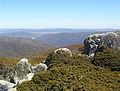 | [15] | |
| 8 | Mount Burbidge | 1,730 | 5,676 | |||
| 9 | Mount Gudgenby | 1,719 | 5,640 | |||
| 10 | Sentry Box Mountain | 1,718 | 5,636 | |||
| 11 | Little Bimberi | 1,654 | 5,427 | |||
| 12 | Mount Franklin | 1,646 | 5,400 | [16] | ||
| 13 | Mavis Ridge | 1,618 | 5,308 | |||
| 14 | Mount McKeahnie | 1,588 | 5,210 | |||
| 15 | Mount Tidbinbilla | 1,583 | 5,194 | |||
| 16 | The Pimple | 1,501 | 4,925 | |||
| 17 | Mount Majura | Canberra Nature Park | 890 | 2,920 | ||
| 18 | Mount Taylor | 856 | 2,808 |  | ||
| 19 | Tuggeranong Hill | 855 | 2,805 |  | ||
| 20 | Mount Ainslie | 842 | 2,762 |  | ||
| 21 | Black Mountain | 812 | 2,664 |  | ||
| 22 | Mount Wanniassa | 809 | 2,654 |  | ||
| 23 | Mount Stromlo | 770 | 2,526 |  | ||
Barrington Tops
Blue Mountains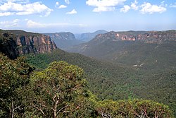 
Budawang Range
Gibraltar Range
Great Dividing Range
Central Tablelands
Mid North Coast region
Monaro region
Illawarra escarpment
Liverpool Range
Lord Howe Island
| McPherson Range
Moonbi Range
Nandewar Range
New England Tableland
Nightcap Range
Snowy Mountains  
Sugarloaf Range
Tweed Range
Warrumbungles
Other mountains
|
Eyre Peninsula
Flinders Ranges
Gammon Ranges
| Gawler Ranges
Mount Lofty Ranges
Musgrave Ranges
|
| Order | Highest peak | Range / nature reserve | Elevation AHD | Image | Notes | |
|---|---|---|---|---|---|---|
| m | ft | |||||
| 1 | Mount Ossa | Du Cane | 1,617 | 5,305 |  | [25] [39] |
| 2 | Legges Tor | Ben Lomond | 1,572 | 5,157 |  | [40] [41] [42] [43] |
| 3 | Giblin Peak | Ben Lomond | 1,569 | 5,148 | [44] [45] [46] | |
| 4 | Mount Pelion West | Pelion | 1,560 | 5,118 |  | [47] [48] [49] |
| 5 | Barn Bluff | Cradle Cirque - Bluff Cirque | 1,559 | 5,115 |  | [50] [51] [52] |
| 6 | Cradle Mountain | 1,545 | 5,069 | 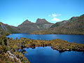 | [53] [54] [55] | |
| 7 | Markham Heights | Ben Lomond | 1,542 | 5,059 | [56] | |
| 8 | Hamilton Crags | Ben Lomond | 1,540 | 5,052 | ||
| 9 | Smithies Peak | 1,527 | 5,010 | [57] [58] | ||
| Stacks Bluff | Ben Lomond | 1,527 | 5,010 |  | [59] [60] [61] | |
| 11 | unnamed peak | Du Cane | 1,520 | 4,987 |  | [62] |
| 12 | Mount Geryon North | Du Cane | 1,516 | 4,974 | 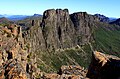 | [63] |
| 13 | Mount Massif | Du Cane | 1,514 | 4,967 | [64] [65] [66] | |
| 14 | Misery Bluff | Ben Lomond | 1,510 | 4,954 | ||
| 15 | Mount Geryon South | Du Cane | 1,509 | 4,951 | [63] | |
| King Davids Peak | 1,509 | 4,951 | [67] | |||
| 17 | Ossian’s Throne | Ben Lomond | 1,498 | 4,915 | ||
| Coalmine Crag | Ben Lomond | 1,498 | 4,915 | |||
| 19 | Mount Gould | Du Cane | 1,485 | 4,872 | 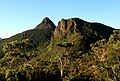 | [68] [69] |
| 20 | Castle Crag | Du Cane | 1,482 | 4,862 |  | [70] |
| Mount Thetis | Du Cane | 1,482 | 4,862 | [71] [72] | ||
| 22 | The Acropolis | Du Cane | 1,481 | 4,859 | 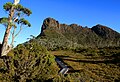 | [73] [74] [75] |
| 23 | Mount Hyperion | 1,480 | 4,856 | |||
| 24 | Magnet Crag | Ben Lomond | 1,464 | 4,803 | ||
| 25 | Mount Pelion East | Pelion | 1,461 | 4,793 | 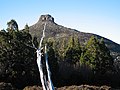 | [76] |
| 26 | Mount Jerusalem | 1,459 | 4,787 | [77] [78] | ||
| 27 | Mount Olympus | 1,449 | 4,754 | [79] | ||
| Cumner Bluff | 1,449 | 4,754 | ||||
| 29 | Mount Gell | 1,447 | 4,747 | [80] [81] | ||
| 30 | Solomons Throne | 1,446 | 4,744 | [82] | ||
| Frenchmans Cap | 1,446 | 4,744 |  | [83] [84] | ||
| 32 | Ironstone Mountain | Great Western Tiers | 1,443 | 4,734 |  | [85] [86] |
| 33 | Eldon Peak | Eldon Range | 1,440 | 4,724 | [87] [88] | |
| 34 | Mount Field West | 1,434 | 4,705 | | ||
| 35 | Mersey Crag | Ben Lomond | 1,432 | 4,698 | ||
| 36 | Walled Mountain | 1,431 | 4,695 | |||
| 37 | Mount Anne | 1,425 | 4,675 |  | ||
| 38 | Western Bluff | 1,420 | 4,659 | |||
| Barrow Mountain | 1,420 | 4,659 | ||||
| 40 | Mount Rufus | 1,416 | 4,646 | |||
| 41 | Macs Mountain | 1,413 | 4,636 | |||
| 42 | Mount Emmett | 1,410 | 4,626 | |||
| 43 | Fisher Bluff | 1,408 | 4,619 | |||
| 44 | Twin Spires | 1,406 | 4,613 | |||
| Mount Barrow | 1,406 | 4,613 | 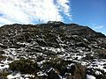 | [89] | ||
| 46 | Mount Hugel | 1,403 | 4,603 | |||
| 47 | Cathedral Mountain | Cathedral | 1,387 | 4,551 | 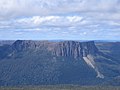 | |
| 48 | Mount Achilles | 1,363 | 4,472 | |||
| 49 | Mount Ragoona | 1,350 | 4,429 |  | ||
| 50 | Mount Mawson | 1,300 | 4,265 |  | ||
| 51 | Mount Murchison | West Coast | 1,275 | 4,183 | [90] [91] | |
| 52 | Kunanyi / Mount Wellington | Wellington | 1,269 | 4,163 |  | [92] [93] [94] |
| 53 | Hartz Peak | Hartz | 1,255 | 4,117 | 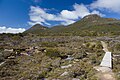 | |
| Mother Cummings Peak | 1,255 | 4,117 |  | |||
| 55 | Forty Lake Peak | 1,248 | 4,094 | |||
| 56 | Mount Roland | 1,234 | 4,049 | 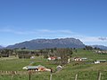 | ||
| 57 | Quamby Bluff | 1,228 | 4,029 | 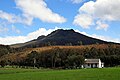 | ||
| 58 | Adamsons Peak | 1,225 | 4,019 | |||
| 59 | Federation Peak | Arthur | 1,224 | 4,016 |  | |
| 60 | Artillery Knob | 1,216 | 3,990 | |||
| 61 | Mount Victoria | 1,207 | 3,960 | |||
| 62 | Interview Pinnacle | 1,200 | 3,937 | |||
| 63 | Mount Geikie | Tyndall | 1,191 | 3,907 | [95] [96] | |
| 64 | Mount Arthur | 1,188 | 3,898 |  | [97] | |
| 65 | Mount Tyndall | Tyndall | 1,179 | 3,868 | ||
| 66 | Mount Jukes | West Coast | 1,168 | 3,832 | [98] | |
| 67 | Mount Sedgwick | West Coast | 1,147 | 3,763 | [99] | |
| 68 | Mount Owen | West Coast | 1,146 | 3,760 |  | [100] |
| 69 | Mount Sorell | West Coast | 1,144 | 3,753 | [101] | |
| 70 | Mount Dundas | West Coast | 1,143 | 3,750 | [102] | |
| 71 | Mount Read | West Coast | 1,123 | 3,684 | [103] | |
| 72 | Proprietary Peak | West Coast | 1,103 | 3,619 | ||
| 73 | Pyramid Peak | West Coast | 1,080 | 3,543 | [104] [105] | |
| unnamed peak | Sticht | 1,080 | 3,543 | [104] [105] | ||
| 75 | West Jukes Peak | West Coast | 1,062 | 3,484 | ||
| 76 | Mount Darwin | West Coast | 1,033 | 3,389 | ||
| 77 | South Jukes Peak | West Coast | 1,014 | 3,327 | ||
| 78 | Mount Hamilton | West Coast | 1,005 | 3,297 | [106] [107] | |
| 79 | Mount Black | West Coast | 950 | 3,117 | ||
| 80 | Victoria Peak | West Coast | 949 | 3,114 | [105] [108] | |
| 81 | Mount Huxley | West Coast | 926 | 3,038 | [99] | |
| 82 | Mount Lyell | West Coast | 917 | 3,009 | ||
| 83 | Mount Strahan | West Coast | 855 | 2,805 | [99] | |
| 84 | Mount Julia | West Coast | 843 | 2,766 | [105] [109] | |
| 85 | South Darwin Peak | West Coast | 780 | 2,559 | [105] [110] | |
| 86 | Mount Selina | West Coast | 760 | 2,493 | [105] [111] | |
| 87 | Mount Munro | Furneaux | 715 | 2,346 | ||
| 88 | Mount Farrell | West Coast | 711 | 2,333 | [105] [112] | |
| 89 | Mount Hamilton | Macquarie Island | 433 | 1,421 | ||
| - | Mount Bischoff |  | ||||
| - | Mount Pleasant | |||||
Victorian Alps   
(1,241 m or 4,072 ft)
|       Grampians
Ballarat and surrounding Highlands
Other Victorian mountains
|
| Order | Highest peak | Range / nature reserve | Elevation AHD | Image | Notes | |
|---|---|---|---|---|---|---|
| m | ft | |||||
| 1 | Mount Zeil | MacDonnell Ranges | 1,531 | 5,023 |  | [123] |
| 2 | Mount Giles | 1,389 | 4,557 | | ||
| 3 | Mount Sonder | 1,380 | 4,530 | 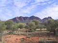 | [124] | |
| 4 | Mount Liebig | 1,274 | 4,180 |  | [125] | |
| 5 | Mount Palmer | Hart Range | 1,117 | 3,665 | [126] | |
| 6 | Kata Tjuta/Mount Olga | Uluṟu-Kata Tjuṯa National Park | 1,066 | 3,497 |  | [127] |
| 7 | Uluru | 863 | 2,831 | | [128] | |
| 8 | Mount Conner | 859 | 2,818 |  | [129] | |
| 9 | Central Mount Stuart | Georgina Basin | 846 | 2,776 |  | [130] |
| 10 | Chambers Pillar | Chambers Pillar Historical Reserve | | |||
| 11 | Mount Hermannsburg | |||||
{{cite journal}}: Cite journal requires |journal= (help)


