Namadgi National Park is a protected area in the south-west of the Australian Capital Territory (ACT), bordering Kosciuszko National Park in New South Wales. It lies approximately 40 kilometres (25 mi) southwest of Canberra, and occupies approximately 46 percent of the ACT's land area.
The Australian Capital Territory as of 2014 contains 46 separate protected areas with a total land area of 1,302 km2 (503 sq mi) or 55.5% of the territory's area, and which managed by Territory and Municipal Services of the ACT government:
Tidbinbilla Nature Reserve is a 54.5 square kilometres (21.0 sq mi) protected area, on the fringe of Namadgi National Park. Tidbinbilla is a short drive from the capital city of Australia, Canberra, in the Australian Capital Territory.

Lesueur National Park is a national park straddling the boundary between the Wheatbelt and Mid West regions of Western Australia, 211 km north of Perth. The park was gazetted in 1992. It includes two mesas known as Mount Lesueur and Mount Michaud, and supports a highly diverse flora.

The Australian Alps are a mountain range in southeast Australia. The range comprises an interim Australian bioregion, and is the highest mountain range in Australia. The range straddles the borders of eastern Victoria, southeastern New South Wales, and the Australian Capital Territory. It contains Australia's only peaks exceeding 2,000 m (6,600 ft) in elevation, and is the only bioregion on the Australian mainland in which deep snow falls annually. The range comprises an area of 1,232,981 ha.

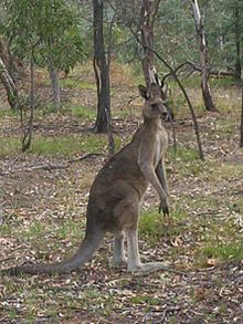
Black Mountain, also known as Galambary to the Ngunnawal people, is a small mountain with an elevation of 812 metres (2,664 ft) AHD that is situated to the west of the Canberra central business district on the northern shore of Lake Burley Griffin, in the Australian Capital Territory of Australia. Black Mountain is protected from development by the Canberra Nature Park and is predominantly covered in native bushland and is a haven to native wildlife.

Campbell is a suburb of Canberra, Australian Capital Territory, Australia. Covering an area to the South East of the central business district, Campbell sits at the base of Mount Ainslie and is bounded to the south east by the Mount Pleasant Nature Reserve. At the 2021 census, Campbell had a population of 6,564 people.

The Australian National Botanic Gardens (ANBG) is a heritage-listed botanical garden located in Acton, Canberra, in the Australian Capital Territory, Australia. Established in 1949, the Gardens is administered by the Australian Government's Department of Agriculture, Water and the Environment. The botanic gardens was added to the Commonwealth Heritage List on 22 June 2004.

Capital Hill is the location of Parliament House, Canberra, at the south apex of the land axis of the Parliamentary Triangle.
The Brindabella Range, commonly called The Brindabellas or The Brindies, is a mountain range located in Australia, on a state and territory border of New South Wales and the Australian Capital Territory (ACT). The range rises to the west of Canberra, the capital city of Australia, and includes the Namadgi National Park in the ACT and the Bimberi Nature Reserve and Brindabella National Park in New South Wales. The Brindabellas are visible to the west of Canberra and form an important part of the city's landscape.

Narrabundah is a leafy, medium density suburb of Canberra, Australian Capital Territory, located in the inner south of the city.
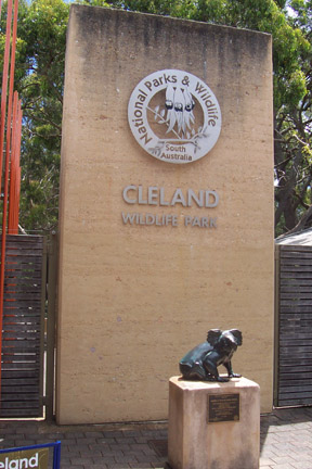
Cleland National Park, formerly Cleland Conservation Park, is a protected area located in the Adelaide Hills, South Australia about 22 kilometres (14 mi) south-east of the Adelaide city centre. It conserves a significant area of natural bushland on the Adelaide Hills face, including Mount Lofty Summit and Waterfall Gully.

Mount Majura is a small mountain with an elevation of 890 metres (2,920 ft) AHD that is located in the northern suburbs of Canberra in the Australian Capital Territory, Australia. Mount Majura lies close to the more prominent Mount Ainslie and is the highest point within the urban boundaries of Canberra. Mount Majura is contained within part of the Canberra Nature Park.

Aranda is a suburb in the district of Belconnen, in the Australian capital city of Canberra. Located at the western foot of Black Mountain and bounded on two sides by nature park, the suburb is characterised by its bush setting. During the planning and development of the suburb, a large proportion of large native trees – predominantly eucalypts – were left in place.
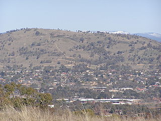
Mount Taylor is a prominent hill with an elevation of 856 metres (2,808 ft) AHD that is located between the Woden Valley, Weston Creek district and Tuggeranong Valley, in Canberra, within the Australian Capital Territory, Australia. Mount Taylor is part of the Canberra Nature Park and is surrounded by the suburbs of Kambah, Fisher, Waramanga, Chifley, Pearce, and Torrens. There are walking tracks to the peak. While there is no public road access to the peak there is a fire trail up the mountain from the end of Waldock St, Chifley where there is also a car park and picnic tables. The fire trail is normally closed to public vehicular access by locked gates, but the gates contain access points for walkers. The trail is especially popular with families and older walkers as it provides the easiest and most leisurely access to the peak. Originally a dirt road, it was partially sealed in 2009 on the steeper grades to make it safer for walkers and mountain bike riders.

Mullum Mullum Creek is a creek in the outer eastern suburbs of Melbourne, Victoria, Australia. It is the main watercourse of the Mullum Mullum Valley, a tributary of the Yarra River and Yarra Valley. For tens of thousands of years it was used as a food and tool source sustainably by the Wurundjeri people, Indigenous Australians of the Kulin nation, who spoke variations of the Woiwurrung language group.

The Illawarra escarpment, or officially the Illawarra Range, is the fold-created cliffs and plateau-eroded outcrop mountain range west of the Illawarra coastal plain south of Sydney, in the state of New South Wales, Australia. The range encloses the Illawarra region which stretches from Stanwell Park in the north to Kiama, Gerringong and the Shoalhaven River in the south.

Mulligans Flat Woodland Sanctuary is a protected area situated in the Gungahlin district in north Canberra in the Australian Capital Territory. It has several trails for walking, running and cycling. The sanctuary functions as a fieldwork site for researchers studying native ecology.
Oakey Hill is a hill near Canberra, Australian Capital Territory. It rises 80 metres (260 ft) above the adjacent south Canberra suburbs of Lyons, Curtin and Weston, and its 66 hectares is one of 33 areas which form Canberra Nature Reserve. The highest point of the hill, 684 metres above sea level, is marked by a survey station.

The Grey Box Reserve, or Greystanes Grey Box Reserve, is a small nature reserve situated in the suburb of Greystanes, New South Wales in Western Sydney, Australia. A remnant bushland of the Cumberland Plain Woodland, it mainly features native vegetation. The reserve is so-named because of its abundance of Eucalyptus moluccana, reflecting the pre-European cultural landscape of the area.