The Australian Capital Territory as of 2014 contains 46 separate protected areas with a total land area of 1,302 km2 (503 sq mi) or 55.5% of the territory's area, and which managed by Territory and Municipal Services of the ACT government:
Tidbinbilla Nature Reserve is a 54.5 square kilometres (21.0 sq mi) protected area, on the fringe of Namadgi National Park. Tidbinbilla is a short drive from the capital city of Australia, Canberra, in the Australian Capital Territory.

Monaro Highway is a 285-kilometre-long (177 mi) highway in Victoria, New South Wales, and the Australian Capital Territory, in Australia, linking Cann River in Victoria to Canberra in the Australian Capital Territory (ACT) via the Monaro region. From its southern terminus, it follows the nearby Cann River upstream towards the New South Wales border through heavily forested terrain. Within New South Wales (NSW), it makes its way through further forest before reaching the pastures typical of the Monaro. There are multiple towns and villages along the highway, including Bombala, Nimmitabel, and Cooma. The terrain within the Monaro is largely hilly, and there are numerous crossings. The road also parallels the former Bombala railway line in several locations. Within the ACT, the road becomes a high volume roadway and serves the southern suburbs of Canberra. The highway has more recently had a grade-separated dual carriageway extension constructed within Canberra, as part of the Eastern Parkway construction project. It is designated part of route M23, and route A23 within Canberra, and route B23 within Victoria and New South Wales, with a concurrency where it also carries route B72 between the two sections of Snowy Mountains Highway.

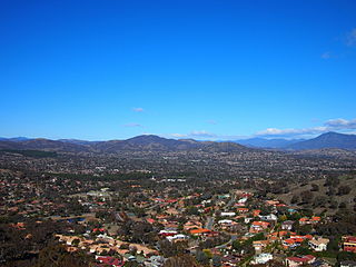
Tuggeranong is a district in the Australian Capital Territory in Australia. The district is subdivided into divisions (suburbs), sections and blocks and is the southernmost district of the Australian Capital Territory. The district comprises nineteen suburbs and occupies 117 square kilometres (45 sq mi) to the east of the Murrumbidgee River.
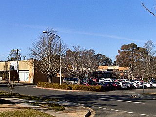
Calwell is a medium-sized suburb of Canberra, Australia in the district of Tuggeranong. Tuggeranong Hill is on its southern border and the Tuggeranong Homestead is to the north. Calwell is located close to the Monaro Highway which provides a direct route to Canberra City and to Cooma.

Conder is one of three suburbs in the Lanyon Valley in Canberra, Australia. It lies in the district of Tuggeranong. The three suburbs are presently the southernmost suburbs of the city, although the small settlement of Tharwa exists only a short distance further south.

Lanyon High School is a secondary school located in Conder, Australian Capital Territory. It serves the Lanyon Valley and surrounding rural areas in the Tuggeranong district of Canberra, Australia. The school was established in 1996 by the ACT department of education to address the needs of young people in years 7–10 as they move from primary school to further education, training or employment.
Waramanga is a suburb of Canberra, Australian Capital Territory, Australia in the district of Weston Creek.
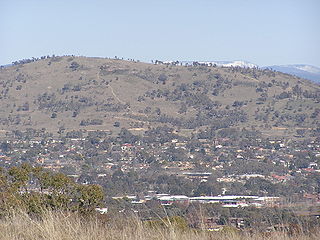
Mount Taylor is a prominent hill with an elevation of 856 metres (2,808 ft) AHD that is located between the Woden Valley, Weston Creek district and Tuggeranong Valley, in Canberra, within the Australian Capital Territory, Australia. Mount Taylor is part of the Canberra Nature Park and is surrounded by the suburbs of Kambah, Fisher, Waramanga, Chifley, Pearce, and Torrens. There are walking tracks to the peak. While there is no public road access to the peak there is a fire trail up the mountain from the end of Waldock St, Chifley where there is also a car park and picnic tables. The fire trail is normally closed to public vehicular access by locked gates, but the gates contain access points for walkers. The trail is especially popular with families and older walkers as it provides the easiest and most leisurely access to the peak. Originally a dirt road, it was partially sealed in 2009 on the steeper grades to make it safer for walkers and mountain bike riders.

Banks is a suburb in the Canberra, Australia district of Tuggeranong. It is the most southerly suburb of Canberra. The suburb is named after Sir Joseph Banks (1743–1820), the botanist who accompanied Captain James Cook to Botany Bay in 1770. The suburb was gazetted on 12 March 1987. The theme of the street names is botany or natural history.

Bonython is a suburb of Tuggeranong, a township in southern Canberra, capital city of Australia.

Chisholm is a suburb in the Canberra, Australia district of Tuggeranong, named after Caroline Chisholm.
Kambah is the northernmost suburb in the district of Tuggeranong, Canberra. It is located just south of Mount Taylor in the Canberra Nature Park. It is located north of the suburbs of Greenway and Wanniassa. It is bounded by Sulwood Drive to the north and Athllon Drive to the south-east.

Theodore is a suburb in the Canberra, Australia district of Tuggeranong. The postcode is 2905. The suburb is named after Edward Granville Theodore (1884–1950), a Queensland premier and deputy Prime Minister. It was gazetted on 5 August 1975. Streets are named after people involved with the civilian war effort during the world wars. The main street through the suburb is named after Sir Lawrence Wackett KBE, DFC, AFC, who is widely regarded as the "father of the Australian aircraft industry".
Scouting and Guiding in the Australian Capital Territory (ACT) of Australia is predominantly represented by the branch of Scouts Australia, and Girl Guides NSW and ACT, a member of Girl Guides Australia.

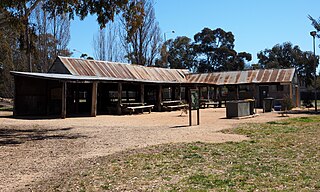
Lanyon is an historic homestead and grazing property located on the southern outskirts of Canberra in the Australian Capital Territory.
Mount Wanniassa is a mountain peak located in Canberra, Australia, nestled between the suburbs of Wanniassa, Farrer, Isaacs and Fadden. The mountain is part of the Wanniassa Hills Nature Reserve, a Canberra Nature Park and adjacent to the Farrer Ridge Nature Reserve. Mount Wanniassa stands at 809 metres (2,654 ft) above sea level, and provides excellent views of the Woden and Tuggeranong areas of Canberra. The mountain can be climbed via the established walking trails on the east and west slopes.
Tharwa Drive is an arterial road, in the southern Australian Capital Territory. The road extends from the Monaro Highway through the Tuggeranong district in Canberra's southern suburbs, connecting with Drakeford Drive before continuing south through the Lanyon Valley and crossing the Murrumbidgee River at the village of Tharwa. Tharwa Drive provides access to the historic Lanyon Homestead, the Murrumbidgee Corridor nature reserve. Restoration of the heritage listed Tharwa Bridge, which carries the road over the Murrumbidgee was completed in 2011, following several years of closures and traffic restrictions.

Yamba Drive is a major arterial road in the southern suburbs of Canberra, the capital city of Australia. It is named after 'Yamba', a pastoral property established by the Eddison family in 1920 as part of the soldier settlement scheme which occupied the area prior to suburban development in the Woden Valley. The road forms part a major link between the Tuggeranong and Woden Valley districts, bypassing the Woden Town Centre and is an important access corridor for Canberra Hospital. Yamba Drive begins at a large roundabout north of the Woden Town Centre. It continues south-east past the Woden Cemetery and Canberra Hospital to a major junction with Hindmarsh Drive, before passing between the residential suburbs of O'Malley, Mawson, Issacs and Farrer before terminating between the Issacs and Farrer ridges in the Canberra Nature Park. Beyond this point, the route continues as Erindale Drive into the suburbs of the Tuggeranong District.
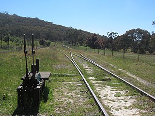
Tuggeranong is a former railway station, sometimes referred to as Tuggeranong Siding or Tuggeranong Platform, that was located on a now-disused portion of the Bombala railway line.


