The Australian Capital Territory as of 2014 contains 46 separate protected areas with a total land area of 1,302 km2 (503 sq mi) or 55.5% of the territory's area, and which managed by Territory and Municipal Services of the ACT government:

Mount Gilboa, sometimes referred to as the Mountains of Gilboa, is the name for a mountain range in Israel. It overlooks the Harod Valley to the north, and the Jordan Valley and Hills to the southeast to the west, respectively.

The Canberra Nature Park is a series of thirty three separate protected areas in and around Canberra, Australian Capital Territory, ranging from bushland hills to lowland native grassland. Many of the areas have previously been cleared for grazing, but many are now being returned to native bushland through revegetation and rehabilitation programs.

The Brindabella Range, commonly called The Brindabellas or The Brindies, is a mountain range located in Australia, on a state and territory border of New South Wales and the Australian Capital Territory (ACT). The range rises to the west of Canberra, the capital city of Australia, and includes the Namadgi National Park in the ACT and the Bimberi Nature Reserve and Brindabella National Park in New South Wales. The Brindabellas are visible to the west of Canberra and form an important part of the city's landscape.

Tuggeranong Hill is located in Tuggeranong, Canberra. It is sometimes incorrectly referred to as Mount Tuggeranong due to its prominence.

The National Triangle, which is referred to as the Parliamentary Triangle, is the ceremonial precinct of Canberra, containing some of Australia's most significant buildings. The National Triangle is formed by Commonwealth, Kings and Constitution Avenues. Buildings within the National Triangle have been located and designed intentionally for visual effect, and those of national significance are popular tourist attractions.
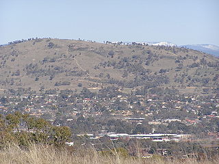
Mount Taylor is a prominent hill with an elevation of 856 metres (2,808 ft) AHD that is located between the Woden Valley, Weston Creek district and Tuggeranong Valley, in Canberra, within the Australian Capital Territory, Australia. Mount Taylor is part of the Canberra Nature Park and is surrounded by the suburbs of Kambah, Fisher, Waramanga, Chifley, Pearce, and Torrens. There are walking tracks to the peak. While there is no public road access to the peak there is a fire trail up the mountain from the end of Waldock St, Chifley where there is also a car park and picnic tables. The fire trail is normally closed to public vehicular access by locked gates, but the gates contain access points for walkers. The trail is especially popular with families and older walkers as it provides the easiest and most leisurely access to the peak. Originally a dirt road, it was partially sealed in 2009 on the steeper grades to make it safer for walkers and mountain bike riders.

Farrer is a suburb in the Canberra, Australia district of Woden. The postcode is 2607.
Fadden is a suburb in the Canberra, Australia district of Tuggeranong. The postcode is 2904. The suburb is named after Sir Arthur Fadden, Prime Minister of Australia briefly in 1941. It was gazetted on 5 August 1975. Its streets are named after Queensland politicians. It is surrounded by Macarthur, Gowrie and Wanniassa. It is bounded by Erindale Drive, the Wanniassa Hills Nature Reserve, Fadden Pine Plantation and Sternberg Crescent.

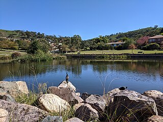
Greenway is a suburb in the Canberra, Australia district of Tuggeranong. The postcode is 2900. The suburb is named after the architect, Francis Greenway (1777–1837). It was gazetted on 17 October 1986. The streets are named after architects. It includes the Tuggeranong Town Centre, Lake Tuggeranong and small residential areas on the northwestern and northeastern shores of the lake.
Kambah is the northernmost suburb in the district of Tuggeranong, Canberra. It is located just south of Mount Taylor in the Canberra Nature Park. It is located north of the suburbs of Greenway and Wanniassa. It is bounded by Sulwood Drive to the north and Athllon Drive to the south-east.

Wanniassa is a suburb in Australia's capital, Canberra: more specifically, in the city's southern district of Tuggeranong. The suburb takes its name from a pastoral property granted to Thomas McQuoid in 1835, which he named after Wanayasa in West Java, Indonesia, where McQuoid had previously owned property. Streets are named after Victorian state politicians and the suburb was gazetted on 21 May 1974.

Tharwa is a township within the District of Paddys River, Australian Capital Territory, 35 kilometres (22 mi) south of Canberra, the capital city of Australia. At the 2016 census, Tharwa had a population of 81.

Erindale Shopping Centre is a large shopping centre located in the Tuggeranong suburb of Wanniassa in the Canberra region of Australia. It stands on the former site of the Erindale Homestead for which it is named, and comprises 121,815.17 m² of both indoor and outdoor land with 76 stores, restaurants, cafes, and entertainment venues.

Tuggeranong Parish is a parish of Murray County, New South Wales, a cadastral unit for use on land titles. It is now about a third of the size it was in the nineteenth century, after most of the land in the parish was transferred to the Australian Capital Territory in 1911. It currently includes a small section of land in New South Wales between the ACT border and Jerrabomberra Creek, but once included most of what is now the Canberra town centre of Tuggeranong.
Gigerline Parish was a former parish of Murray County, New South Wales, a cadastral unit for use on land titles. It was formed in the nineteenth century and existed until 1 January 1911, when the Seat of Government (Administration) Act 1910 came into force, after the land was transferred to the Commonwealth government in 1909 to be used to form the Australian Capital Territory.

Trinity Christian School, founded in 1980, is a private Christian P-12 school located in Wanniassa in the Tuggeranong Valley of Canberra, ACT, Australia.
Mount Franklin is a mountain with an elevation of 1,646 metres (5,400 ft) AHD in the Brindabella Ranges that is located on the border between the Australian Capital Territory and New South Wales, Australia. The summit of the mountain is located in the Australian Capital Territory.
Oakey Hill is a hill near Canberra, Australian Capital Territory. It rises 80 metres above the adjacent south Canberra suburbs of Lyons, Curtin and Weston, and its 66 hectares is one of 33 areas which form Canberra Nature Reserve. The highest point of the hill, 684 metres above sea level, is marked by a survey station.
