Canberra is the capital city of Australia. Founded following the federation of the colonies of Australia as the seat of government for the new nation, it is Australia's largest inland city and the eighth-largest city overall. The city is located at the northern end of the Australian Capital Territory at the northern tip of the Australian Alps, the country's highest mountain range. As of June 2021, Canberra's estimated population was 453,558.
The history of Canberra details the development of the city of Canberra from the time before European settlement to the city's planning by the Chicago architect Walter Burley Griffin in collaboration with Marion Mahony Griffin, and its subsequent development to the present day.

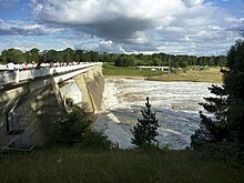
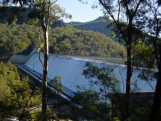
Lake Burley Griffin is an artificial lake in the centre of Canberra, the capital of Australia. It was completed in 1963 after the Molonglo River, which ran between the city centre and Parliamentary Triangle, was dammed. It is named after Walter Burley Griffin, the American architect who won the competition to design the city of Canberra.

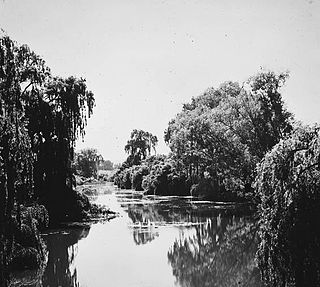
The Molonglo River, a perennial river that is part of the Murrumbidgee catchment within the Murray–Darling basin, is located in the Monaro and Capital Country regions of New South Wales and the Australian Capital Territory, in Australia.

Yarralumla is a large inner south suburb of Canberra, the capital city of Australia. Located approximately 3.5 kilometres (2.2 mi) south-west of the city, Yarralumla extends along the south-west bank of Lake Burley Griffin from Scrivener Dam to Commonwealth Avenue.

The National Carillon is a large carillon situated on Queen Elizabeth II Island in Lake Burley Griffin, central Canberra, in the Australian Capital Territory, Australia. The carillon is managed and maintained by the National Capital Authority on behalf of the Commonwealth of Australia. It has 57 bells, ranging nearly 5 octaves from the 6,108 kg (13,466 lb) bass bell in F# to the 8 kg (18 lb) treble bell in D.
The Canberra Golf Club, later known as the Royal Canberra Golf Club, was formed in 1926. Its original grounds were behind the Hotel Canberra on the river flats on both sides of the Molonglo River.

Charles Robert Scrivener was an Australian surveyor, and the person who surveyed numerous sites in New South Wales for the selection of a site for the Australian Capital Territory and Australia's capital city, Canberra.

The Queanbeyan River, a perennial stream that is part of the Molonglo catchment within the Murray–Darling basin, is located in the Monaro and Capital Country regions of New South Wales and the Australian Capital Territory, in Australia. The river is 104 kilometres (65 mi) in length with a catchment area of 96,000 hectares. The Queanbeyan River and the Cotter River meet the potable water supply needs of the Canberra and Queanbeyan region and whose water quality is specifically protected under Federal legislation.
The history of the Australian Capital Territory (ACT) as a separate administrative division began in 1911, when it was transferred from New South Wales to the Australian federal government. The territory contains Australia's capital city Canberra and various smaller settlements. Until 1989, it also administered the Jervis Bay Territory, a small coastal region.

Googong Dam is a minor ungated earth and rock fill with clay core embankment dam with concrete chute spillway plus a nearby 13 metres (43 ft) high earthfill saddle embankment across the Queanbeyan River upstream of Queanbeyan in the Capital Country region of New South Wales, Australia. The dam's purpose includes water supply for Canberra and Queanbeyan. The impounded reservoir is called Googong Reservoir.
Tallowa Dam, completed in 1976, is a concrete gravity dam with central overflow spillway, located on the Shoalhaven River, downstream from the river's confluence with the Kangaroo River. The dam wall of 325 cubic metres (11,500 cu ft) is 43 metres (141 ft) high and 528 metres (1,732 ft) in length. At 100% capacity, the dam wall holds back approximately 85,500 megalitres and creates the impounded reservoir of Lake Yarrunga that has a surface area of 831 hectares, drawn from a catchment area of 5,750 square kilometres (2,220 sq mi). The spillway has a discharge capacity of 27,600 cubic metres per second (970,000 cu ft/s).
The Molonglo Plain generally refers to the flood plain of the Molonglo River and specifically the one located in the Australian Capital Territory that was inundated during the mid-1960s in order to create Lake Burley Griffin. This plain was one of fours plains - the Ginninderra Plain, the Limestone Plain, and the Tuggeranong Plain are the others - upon which the city of Canberra is situated.
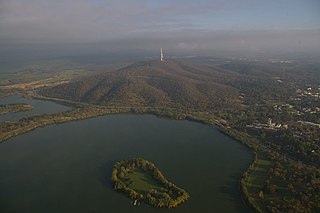
Springbank Island is an island located on Lake Burley Griffin in Canberra, Australian Capital Territory. Springbank Island is named after a former agricultural property that was partially submerged to create Lake Burley Griffin. An elevated part of the former property now comprises the island.

The history of Lake Burley Griffin, an artificial body of water in Canberra, the capital of Australia, is a long one. Following its initial design in the 1910s, extensive political disputes occurred until it was finally built in the 1960s.

Sullivans Creek, a partly perennial stream of the Murrumbidgee catchment within the Murray–Darling basin, is located in Canberra, Australian Capital Territory, Australia.
Jerrabomberra Creek, a partly perennial stream of the Murrumbidgee catchment within the Murray–Darling basin, is located in the Capital Country region spanning both New South Wales and the Australian Capital Territory, Australia.
Scott's Crossing Road was a former roadway connecting north and south Canberra, across the Molonglo River floodplain. It was named after John Scott, who was an early settler in the region, and whose homestead was located at its southern end. It was submerged by the filling of Lake Burley Griffin.

The Commonwealth Avenue Bridge are two parallel pre-stressed concrete box girder road bridges that carry Commonwealth Avenue across Lake Burley Griffin, and connect Parkes and City in Canberra, in the Australian Capital Territory, Australia.

Lake Daylesford is an artificial lake in the town of Daylesford, Victoria, Australia. It was completed in either 1927 or 1929 after many years of campaigning since 1893. It was designed by Walter Burley Griffin, the American architect who won the competition to design the city of Canberra. Lake Daylesford was formed when the dam wall was built across Wombat Creek aboe the Central Springs in 1929. The town wanted an ornamental body of water to beautify the scarred creek landscape.