
The Australian Capital Territory (ACT), known as the Federal Capital Territory (FCT) until 1938, is a landlocked federal territory of Australia containing the national capital Canberra and some surrounding townships. It is located in southeastern Australian mainland as an enclave completely within the state of New South Wales. Founded after Federation as the seat of government for the new nation, all important institutions of the Australian Government are headquartered in the territory.

Canberra is the capital city of Australia. Founded following the federation of the colonies of Australia as the seat of government for the new nation, it is Australia's largest inland city and the eighth-largest city overall. Unusual among Australian cities, it is an entirely planned city. The city is located at the northern end of the Australian Capital Territory at the northern tip of the Australian Alps, the country's highest mountain range. As of June 2020, Canberra's estimated population was 431,380.

The Murrumbidgee River is a major tributary of the Murray River within the Murray–Darling basin and the second longest river in Australia. It flows through the Australian state of New South Wales and the Australian Capital Territory, descending 1,500 metres (4,900 ft) over 1,485 kilometres (923 mi), generally in a west-northwesterly direction from the foot of Peppercorn Hill in the Fiery Range of the Snowy Mountains towards its confluence with the Murray River near Boundary Bend.

The Molonglo River, a perennial river that is part of the Murrumbidgee catchment within the Murray–Darling basin, is located in the Monaro and Capital Country regions of New South Wales and the Australian Capital Territory, in Australia.

The District of Belconnen is one of the original eighteen districts of the Australian Capital Territory (ACT), used in land administration. The district is subdivided into 27 divisions (suburbs), sections and blocks. The district of Belconnen is largely composed of Canberra suburbs.

The District of Tuggeranong is one of the original eighteen districts of the Australian Capital Territory used in land administration. The district is subdivided into divisions (suburbs), sections and blocks and is the southernmost town centre of Canberra, the capital city of Australia. The district comprises nineteen suburbs and occupies 117 square kilometres (45 sq mi) to the east of the Murrumbidgee River.

The 2003 Canberra bushfires caused severe damage to the suburbs and outer areas of Canberra, the capital city of Australia, during 18–22 January 2003. Almost 70% of the Australian Capital Territory's (ACT) pastures, pine plantations, and nature parks were severely damaged, and most of the Mount Stromlo Observatory was destroyed. After burning for a week around the edges of the ACT, the fires entered the suburbs of Canberra on 18 January 2003. Over the next ten hours, four people died, over 490 were injured, and 470 homes were destroyed or severely damaged, requiring a significant relief and reconstruction effort.

The District of Gungahlin is one of the original eighteen districts of the Australian Capital Territory used in land administration. Gungahlin Region is one of fastest growing regions within Australia. The district is subdivided into divisions (suburbs), sections and blocks. Gungahlin is an Aboriginal word meaning either "white man's house" or "little rocky hill".

The suburbs of Canberra are organised into a hierarchy of districts, town centres, group centres, local suburbs and other industrial areas and villages. While these divisions have no formal role in the governance or administration of the city, they formed a basis for the planning and development of the city and are significant to the city's commercial and social activities.

Bonython is a suburb of Tuggeranong, a township in southern Canberra, capital city of Australia.

Emu Ridge is a housing estate in the suburb of Belconnen, located in the district of Belconnen, in Canberra, within the Australian Capital Territory (ACT) of Australia. Emu Ridge is bounded by Benjamin Way, College Street, Eastern Valley Way and Belconnen Way; Hennessy Street and Condell Street are the two main thoroughfares, with many cul-de-sacs off these.

Stranger Pond, a series of two artificial lakes sourced from stormwater discharge from urban and rural areas, are located in the Tuggeranong district of Canberra, within the Australian Capital Territory, Australia. One is called 'Upper Stranger Pond' and is located in the suburb of Isabella Plains. The other is called 'Lower Stranger Pond' and is located in the suburb of Bonython. Lower Stranger Pond is widely known simply as 'Stranger Pond'. Google Maps only labels one of the two ponds - that being the one in Bonython and calls it 'Stranger Pond.'

Ginninderra Creek, a partly perennial stream of the Murrumbidgee catchment within the Murray-Darling basin, is located in the Capital Country region spanning both the Australian Capital Territory and New South Wales, Australia.

Sullivans Creek, a partly perennial stream of the Murrumbidgee catchment within the Murray-Darling basin, is located in Canberra, Australian Capital Territory, Australia.
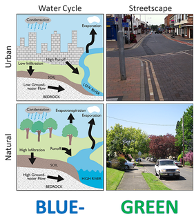
Water-sensitive urban design (WSUD) is a land planning and engineering design approach which integrates the urban water cycle, including stormwater, groundwater and wastewater management and water supply, into urban design to minimise environmental degradation and improve aesthetic and recreational appeal. WSUD is a term used in the Middle East and Australia and is similar to low-impact development (LID), a term used in the United States; and Sustainable Drainage System (SuDS), a term used in the United Kingdom.

Gibraltar Creek, a perennial stream that is part of the Murrumbidgee catchment within the Murray-Darling basin, is located in the Australian Capital Territory, Australia.

Tuggeranong Creek, a partly perennial stream of the Murrumbidgee catchment within the Murray-Darling basin, is located in the Tuggeranong district of Canberra, within the Australian Capital Territory, Australia.

The Tidbinbilla River, a perennial stream that is part of the Murrumbidgee catchment within the Murray-Darling basin, is located in the Australian Capital Territory, Australia.

The Jerrabomberra District is a district of Canberra. It is situated to the southeast of South Canberra, south of the Molonglo River, east of Woden Valley and north east of Tuggeranong and west of the New South Wales border. It includes the suburbs of Beard, Hume, Oaks Estate and Symonston and the military communications and logistics facility HMAS Harman. At the 2016 census, it had a total population of 1,240, comprising 559 in Symonston, 430 in Hume and 251 in Oaks Estate and Beard At the 2011 census, 13 also lived in Harman. It is named after Jerrabomberra Creek, which runs through it, Jerrabomberra is derived from the Aboriginal word, meaning "afraid of lightning".

