| Paddys | |
|---|---|
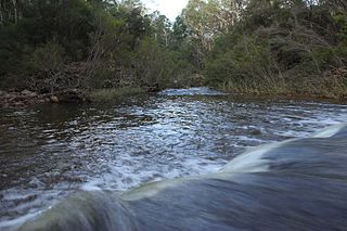
 Paddys River viewed from Gibraltar Peak | |
| Location | |
| Country | Australia |
| Territory | Australian Capital Territory |
| Region | South Eastern Highlands (IBRA), Capital Country |
| Physical characteristics | |
| Source confluence | Blue Gum Creek and Punchbowl Creek |
| ⁃ location | Castle Hill in Tidbinbilla Nature Reserve |
| ⁃ coordinates | 35°29′32″S148°58′58″E / 35.49222°S 148.98278°E |
| ⁃ elevation | 758 m (2,487 ft) |
| Mouth | confluence with Cotter River |
⁃ location | below Mount Stromlo |
⁃ coordinates | 35°19′44″S148°56′19″E / 35.32889°S 148.93861°E Coordinates: 35°19′44″S148°56′19″E / 35.32889°S 148.93861°E |
⁃ elevation | 477 m (1,565 ft) |
| Length | 28 km (17 mi) |
| Basin features | |
| River system | Murrumbidgee catchment, Murray–Darling basin |
| Tributaries | |
| ⁃ left | Gibraltar Creek, Tidbinbilla River |
| National park | Namadgi |
| [1] | |

Paddys River, a perennial stream that is part of the Murrumbidgee catchment within the Murray-Darling basin, is located in the Australian Capital Territory, Australia.
A perennial stream or perennial river is a stream or river (channel) that has continuous flow in parts of its stream bed all year round during years of normal rainfall. "Perennial" streams are contrasted with "intermittent" streams which normally cease flowing for weeks or months each year, and with "ephemeral" channels that flow only for hours or days following rainfall. During unusually dry years, a normally perennial stream may cease flowing, becoming intermittent for days, weeks, or months depending on severity of the drought. The boundaries between perennial, intermittent, and ephemeral channels are not defined, and subject to a variety of identification methods adopted by local governments, academics, and others with a need to classify stream-flow permanence.

Murrumbidgee River, a major tributary of the Murray River within the Murray–Darling basin and the second longest river in Australia. It flows through the Australian state of New South Wales and the Australian Capital Territory. It descends 1,500 metres (4,900 ft) as it flows 1,485 kilometres (923 mi) in a west-northwesterly direction from the foot of Peppercorn Hill in the Fiery Range of the Snowy Mountains towards its confluence with the Murray River near Boundary Bend.

The Australian Capital Territory, formerly known as the Federal Capital Territory until 1938 and commonly referred to as the ACT, is a federal territory of Australia containing the Australian capital city of Canberra and some surrounding townships. It is located in the south-east of the country and is an enclave within the state of New South Wales. Founded after federation as the seat of government for the new nation, all important institutions of the Australian federal government are centred in the Territory.