Canberra is the capital city of Australia. Founded following the federation of the colonies of Australia as the seat of government for the new nation, it is Australia's largest inland city and the eighth-largest Australian city overall. The city is located at the northern end of the Australian Capital Territory at the northern tip of the Australian Alps, the country's highest mountain range. As of June 2022, Canberra's estimated population was 456,692.

Walter Burley Griffin was an American architect and landscape architect. He designed Canberra, Australia's capital city, the New South Wales towns of Griffith and Leeton, and the Sydney suburb of Castlecrag.

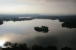
Lake Burley Griffin is an artificial lake in the centre of Canberra, the capital of Australia. It was completed in 1963 after the Molonglo River, which ran between the city centre and Parliamentary Triangle, was dammed. It is named after Walter Burley Griffin, the American architect who won the competition to design the city of Canberra.

The Molonglo River is a perennial river that is part of the Murrumbidgee catchment within the Murray–Darling basin. It is located in the Monaro and Capital Country regions of New South Wales and the Australian Capital Territory, in Australia.

Yarralumla is a large inner south suburb of Canberra, the capital city of Australia. Located approximately 3.5 km (2.2 mi) south-west of the city, Yarralumla extends along the south-west bank of Lake Burley Griffin from Scrivener Dam to Commonwealth Avenue.

Black Mountain, also known as Galambary to the Ngunnawal people, is a small mountain with an elevation of 812 metres (2,664 ft) AHD that is situated to the west of the Canberra central business district on the northern shore of Lake Burley Griffin, in the Australian Capital Territory of Australia. Black Mountain is protected from development by the Canberra Nature Park and is predominantly covered in native bushland and is a haven to native wildlife.

Parkes is an inner southern suburb of the Canberra Central district of Canberra, located within the Australian Capital Territory of Australia. Located southeast of the Canberra central business district, Parkes contains the Parliamentary Triangle and many of the national monuments of Australia's capital city.

Barton is a suburb of Canberra, Australian Capital Territory, Australia. At the 2021 census, Barton had a population of 1,946 people.

The National Triangle, which is referred to as the Parliamentary Triangle, is the ceremonial precinct of Canberra, containing some of Australia's most significant buildings. The National Triangle is formed by Commonwealth, Kings and Constitution Avenues. Buildings within the National Triangle have been located and designed intentionally for visual effect, and those of national significance are popular tourist attractions.

Kings Park is a park in Canberra, Australia on the shore of Lake Burley Griffin.
Spinnaker Island may refer to:

Queen Elizabeth II Island, formerly Aspen Island, is an artificial island located within Lake Burley Griffin, in Canberra, Australian Capital Territory, Australia. It lies within the Parliamentary Triangle.
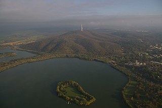
Springbank Island is an island located on Lake Burley Griffin in Canberra, Australian Capital Territory. Springbank Island is named after a former agricultural property that was partially submerged to create Lake Burley Griffin. An elevated part of the former property now comprises the island.
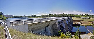
Scrivener Dam is a concrete gravity dam that impounds the Molonglo River in Canberra, Australian Capital Territory. The dam creates Lake Burley Griffin, which was established for recreational and ornamental purposes. Named in honour of surveyor Charles Scrivener, the dam was officially inaugurated on 20 September 1963 and the official filling of the lake commemorated on 17 October 1964 by the Prime Minister, Robert Menzies.

Canberra Central is a district in the Australian Capital Territory in Australia. Consisting of both the subdivisions of North Canberra and South Canberra. The district is subdivided into divisions (suburbs), sections and blocks. The district of Canberra Central lies entirely within the bounds of the city of Canberra, the capital city of Australia.

The history of Lake Burley Griffin, an artificial body of water in Canberra, the capital of Australia, is highly complex. Following its initial design in the 1910s, extensive political disputes occurred until it was finally built in the 1960s.

Sullivans Creek, a partly perennial stream of the Murrumbidgee catchment within the Murray–Darling basin, is located in Canberra, Australian Capital Territory, Australia.
The Immigration Bridge was a proposed footbridge in Canberra, the capital of Australia. It was proposed that it be built between the National Museum of Australia and Lennox Gardens on the south shore of the West Basin of Lake Burley Griffin, in the centre of the city.
Jerrabomberra Creek, a partly perennial stream of the Murrumbidgee catchment within the Murray–Darling basin, is located in the Capital Country region spanning both New South Wales and the Australian Capital Territory, Australia.
The Rocky Ponds Creek, a watercourse that is part of the Murrumbidgee catchment within the Murray–Darling basin, is located in the South West Slopes region of New South Wales, Australia.