
The Australian Capital Territory, known as the Federal Capital Territory (FCT) until 1938, is a landlocked federal territory of Australia containing the national capital Canberra and some surrounding townships. It is located in southeastern Australian mainland as an enclave completely within the state of New South Wales. Founded after Federation as the seat of government for the new nation, all important institutions of the Australian Government are headquartered in the territory.

Canberra is the capital city of Australia. Founded following the federation of the colonies of Australia as the seat of government for the new nation, it is Australia's largest inland city and the eighth-largest city overall. Unusual among Australian cities, it is an entirely planned city. The city is located at the northern end of the Australian Capital Territory at the northern tip of the Australian Alps, the country's highest mountain range. As of June 2020, Canberra's estimated population was 431,380.

Civic is the city centre or central business district of Canberra. "Civic" is a common name for the district, but it is also called Civic Centre, City Centre, Canberra City and Canberra, and its official division name is City.

Yarralumla is a large inner south suburb of Canberra, the capital city of Australia. Located approximately 3.5 kilometres (2.2 mi) south-west of the city, Yarralumla extends along the south-west bank of Lake Burley Griffin from Scrivener Dam to Commonwealth Avenue.

The Division of Fenner is an Australian Electoral Division in the Australian Capital Territory and the Jervis Bay Territory. As of the 2018 redistribution, it includes Gungahlin and the part of Belconnen north of Belconnen Way and west of Eastern Valley Way, Aikman Drive and William Slim Drive. It also includes the Jervis Bay Territory.

The Division of Canberra is an Australian electoral division in the Australian Capital Territory. It is named for the city of Canberra, Australia's national capital, and includes all of central Canberra, Kowen, Majura, as well as part of Weston Creek, Woden Valley, Molonglo Valley, Belconnen, and Jerrabomberra. It is currently held by Alicia Payne of the Labor Party.

Braddon is an inner north suburb of Canberra, Australian Capital Territory, Australia located adjacent to the Canberra CBD.

Turner is a leafy early Canberra suburb, close to Canberra City and the Australian National University.

Griffith is an early inner-south suburb of Canberra, Australian Capital Territory, Australia.

The District of Gungahlin is one of the original eighteen districts of the Australian Capital Territory used in land administration. The Gungahlin Region is one of fastest growing regions within Australia. The district is subdivided into divisions (suburbs), sections and blocks. Gungahlin is an Aboriginal word meaning either "white man's house" or "little rocky hill".

The Albert Hall is a hall in Canberra, Australia, used for entertainment. It is on Commonwealth Avenue between Commonwealth Bridge and the Hotel Canberra in the suburb of Yarralumla.

Lyneham is a suburb of Canberra, Australia in the North Canberra district. It is named after Sir William Lyne, premier of New South Wales from 1899 to 1901. The suburb name was gazetted in 1928, but development did not commence until 1958. The streets of Lyneham are named after artists and people associated with the development of early Canberra.

The Dickson Centre, located in the suburb of Dickson, is a group centre in the inner northern suburbs of Canberra.
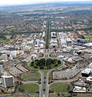
City Hill is a park located in Canberra, Australia on one of the points of the Parliamentary Triangle, a feature of Walter Burley Griffin's plan for the city. The park is surrounded by Vernon Circle, at the south end of Northbourne Avenue, but beyond Vernon Circle it is further surrounded by the concentric London Circuit, and the area between Vernon Circle and London Circuit can also be seen as part of the hill. City Hill is an integral part of the city centre design. To the south of the hill Northbourne Avenue becomes Commonwealth Avenue, and further along is Commonwealth Avenue bridge.

Manuka is an area in the Inner South district of Canberra, Australia covering parts of the suburbs of Griffith and Forrest. Manuka Shops, Manuka Oval, Manuka Swimming Pool, and Manuka Circle take their name from the park in the area.
Transport Canberra & City Services (TCCS) is a directorate of the Government of the Australian Capital Territory of the Australian Capital Territory, responsible for managing roads, footpaths and cycle paths and managing public transport in Canberra including ACTION buses and the Canberra Light Rail through its Transport Canberra division.

Corroboree Park is in Ainslie, ACT, Canberra, Australia. It is shaped like a semicircle, and is associated with the Aboriginal use of the area prior to European settlement in Canberra. The park was created around 1925 around the 'Corroboree Tree' located in the park. It is in a heritage registered area, and is also a registered heritage park.
Jerrabomberra Creek, a partly perennial stream of the Murrumbidgee catchment within the Murray–Darling basin, is located in the Capital Country region spanning both New South Wales and the Australian Capital Territory, Australia.
The National Arboretum Canberra is a 250-hectare arboretum in Canberra, the national capital of Australia, created after the area was burned out as a result of the Christmas 2001 and 2003 Canberra bushfires: The Himalayan Cedar forest lost about one third of its trees, and the commercial Radiata Pine plantation was burned out, allowing the arboretum to be created.

The Canberra light rail network, also known as Canberra Metro, is a light rail system serving the city of Canberra, Australia. The initial 12-kilometre (7.5 mi) line links the northern town centre of Gungahlin to the city centre (Civic) and has 14 stops. Services commenced on 20 April 2019. A 14th stop at Sandford Street in Mitchell commenced operation in September 2021.
