
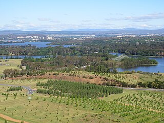
Black Mountain Peninsula, located in Acton, Australian Capital Territory, a suburb of the capital Canberra, is a prominent area on the western region of Lake Burley Griffin. It is popular for water recreation and picnics. [1]
Black Mountain Peninsula, located in Acton, Australian Capital Territory, a suburb of the capital Canberra, is a prominent area on the western region of Lake Burley Griffin. It is popular for water recreation and picnics. [1]

The Australian Capital Territory, known as the Federal Capital Territory (FCT) until 1938, is a landlocked federal territory of Australia containing the national capital Canberra and some surrounding townships. It is located in southeastern Australian mainland as an enclave completely within the state of New South Wales. Founded after Federation as the seat of government for the new nation, all important institutions of the Australian Government are headquartered in the territory.

The Balkans, also known as the Balkan Peninsula, is a geographic area in southeastern Europe with various geographical and historical definitions. The region takes its name from the Balkan Mountains that stretch throughout the whole of Bulgaria. The Balkan Peninsula is bordered by the Adriatic Sea in the northwest, the Ionian Sea in the southwest, the Aegean Sea in the south, the Turkish Straits in the east, and the Black Sea in the northeast. The northern border of the peninsula is variously defined. The highest point of the Balkans is Mount Musala, 2,925 metres (9,596 ft), in the Rila mountain range, Bulgaria.

The Baja California peninsula is a peninsula in northwestern Mexico. It separates the Gulf of California from the Pacific Ocean. The peninsula extends from Mexicali, Baja California, in the north to Cabo San Lucas, Baja California Sur, in the south.
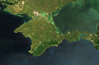
Crimea is a peninsula in Eastern Europe. It is situated along the northern coast of the Black Sea, and has a population of 2.4 million, made up mostly of ethnic Russians with significant Ukrainian and Crimean Tatar minorities, among others. The peninsula is almost entirely surrounded by both the Black Sea and the smaller Sea of Azov; it is located south of Kherson Oblast in Ukraine, to which it is connected by the Isthmus of Perekop, and west of Krasnodar Krai in Russia, from which it is separated by the Strait of Kerch though linked by the Crimean Bridge since 2018. The Arabat Spit is located to its northeast, a narrow strip of land that separates a system of lagoons named Sivash from the Sea of Azov. Across the Black Sea to the west lies Romania and to the south is Turkey.

Western Asia, West Asia, or Southwest Asia, is the westernmost subregion of the larger geographical region of Asia, as defined by some academics, UN bodies and other institutions. It is almost entirely a part of the Middle East, and includes Anatolia, the Arabian Peninsula, Iran, Mesopotamia, the Armenian Highlands, the Levant, the island of Cyprus, the Sinai Peninsula, and partly the Caucasus Region (Transcaucasia). The region is considered to be separated from Africa by the Isthmus of Suez in Egypt, and separated from Europe by the waterways of the Turkish Straits and the watershed of the Greater Caucasus. Central Asia lies to its northeast, while South Asia lies to its east. Eight seas surround the region (clockwise): the Aegean Sea, the Black Sea, the Caspian Sea, the Persian Gulf, the Arabian Sea, the Gulf of Aden, the Red Sea, and the Mediterranean Sea.

Najran is a region of Saudi Arabia, located in the south of the country along the border with Yemen. It has an area of 149,511 km². Its capital is Najran.

Black Mountain, also known as Galambary to the Ngunnawal people, is a small mountain with an elevation of 812 metres (2,664 ft) AHD that is situated to the west of the Canberra central business district on the northern shore of Lake Burley Griffin, in the Australian Capital Territory of Australia. Black Mountain is protected from development by the Canberra Nature Park and is predominantly covered in native bushland and is a haven to native wildlife.
The Royal Canberra Hospital implosion was a failed building implosion that killed one person and injured nine others. The implosion occurred on 13 July 1997, when the city's superseded hospital buildings at Acton Peninsula on Lake Burley Griffin were demolished to make way for the National Museum of Australia.
The Canberra Golf Club, later known as the Royal Canberra Golf Club, was formed in 1926. Its original grounds were behind the Hotel Canberra on the river flats on both sides of the Molonglo River.

Commonwealth Place is located on the southern shore of Lake Burley Griffin, Canberra. It lies along the ‘water axis’ running along the lake from Black Mountain. Commonwealth Place is the location of the Gallery of Australian Design, Reconciliation Place, a restaurant and Speakers Square. Walter Burley Griffin, the architect who designed Canberra, envisaged that the area would be the site of a "water gate" which would have a terrace above it, providing a "forum for the people". Griffin's vision was for a long time left unrecognised but as of 2005 the area was being developed to reflect the original plan.
Yarramundi Reach is a small peninsula on the western end of Lake Burley Griffin, in the Australian Capital Territory, close to Scrivener Dam. It is also the name for the area of water on Lake Burley Griffin between it and Weston Park.
Mount Stromlo High School is a public high school located in Waramanga, Australian Capital Territory. Mount Stromlo came into being after the merger of Weston Creek high school & Holder high school in 1990. The school is a traditional coeducational public school for students in year 7 to year 10.

Murray County was one of the original Nineteen Counties in New South Wales and is now one of the 141 Lands administrative divisions of New South Wales. It included the area which is now part of Canberra and as far north as Lake George and Yass. It was originally bounded on the west by the Murrumbidgee River, on the east by the Shoalhaven River and on the north by the Yass River. A large area of the county was transferred to the Commonwealth government in 1909 in the Seat of Government Acceptance Act to make part of the Australian Capital Territory, along with land in Cowley County. Since then, the ACT border is now part of the western boundary. Part of the ACT border is determined by property boundaries in the Parish of Keewong, in the County of Murray; specifically the southern end of portions 177, 218, 211, 36, and 38. This is mentioned in the Seat of Government Acceptance Act of 1909.
The Australian Headquarters Joint Operations Command (HQJOC) is the Australian Defence Force's (ADF) operational level headquarters responsible for the command and control of ADF operations worldwide. It was formed from "Headquarters Australian Theatre" (HQAST) in 2004 to reflect the changing internal structure of the ADF and the need to establish a purpose-built, co-located joint headquarters. Since December 2008, it has been based adjacent to the Kowen district of the Australian Capital Territory, just south of the Kings Highway, about 15 km east of Queanbeyan and 15 km south of Bungendore. The complex is known as the General John Baker Complex, named after a former Chief of Defence Force who was a strong advocate of joint command and control.

Greece is a country of the Balkans, in Southeastern Europe, bordered to the north by Albania, North Macedonia and Bulgaria; to the east by Turkey, and is surrounded to the east by the Aegean Sea, to the south by the Cretan and the Libyan Seas, and to the west by the Ionian Sea which separates Greece from Italy.

Sullivans Creek, a partly perennial stream of the Murrumbidgee catchment within the Murray–Darling basin, is located in Canberra, Australian Capital Territory, Australia.
Jerrabomberra Creek, a partly perennial stream of the Murrumbidgee catchment within the Murray–Darling basin, is located in the Capital Country region spanning both New South Wales and the Australian Capital Territory, Australia.
The Lindsay Pryor National Arboretum is an arboretum on the Yarramundi Reach peninsula in Canberra, the capital of Australia. It is named after Lindsay Pryor, a noted Australian botanist. The site is located at the western end of Lake Burley Griffin and is used for research and recreation.
Haig Park is a park in the suburbs of Braddon and Turner in Canberra, Australia. It lies on either side of Northbourne Avenue.