
A median strip, central reservation, roadway median, or traffic median is the reserved area that separates opposing lanes of traffic on divided roadways such as divided highways, dual carriageways, freeways, and motorways. The term also applies to divided roadways other than highways, including some major streets in urban or suburban areas. The reserved area may simply be paved, but commonly it is adapted to other functions; for example, it may accommodate decorative landscaping, trees, a median barrier, or railway, rapid transit, light rail, or streetcar lines.

Braddon is an inner north suburb of Canberra, Australian Capital Territory, Australia located adjacent to the Canberra CBD.

The O-Bahn Busway is a guided busway that is part of the bus rapid transit system servicing the northeastern suburbs of Adelaide, South Australia. The O-Bahn system was conceived by Daimler-Benz to enable buses to avoid traffic congestion by sharing tram tunnels in the German city of Essen.

Flatbush Avenue is a major avenue in the New York City Borough of Brooklyn. It runs from the Manhattan Bridge south-southeastward to Jamaica Bay, where it joins the Marine Parkway–Gil Hodges Memorial Bridge, which connects Brooklyn to the Rockaway Peninsula in Queens. The north end was extended from Fulton Street to the Manhattan Bridge as "Flatbush Avenue Extension".

Gungahlin is a district in the Australian Capital Territory, one of the fastest growing regions in Australia. The district is subdivided into suburbs, sections and blocks. Gungahlin is an Aboriginal word meaning either "white man's house" or "little rocky hill".
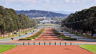
Anzac Parade is a significant road and thoroughfare in the Australian capital Canberra, used for ceremonial occasions and the site of many major military memorials.

The Dickson Centre, located in the suburb of Dickson, is a group centre in the inner northern suburbs of Canberra.

Dickson is a suburb in the Inner North of Canberra, Australia. It is named after Sir James R. Dickson (1832–1901) who was a Queensland advocate of Australian Federation and one of the founders of the Australian Constitution. There is no specific theme for street names.

Tuggeranong Parkway is an 11-kilometre-long (6.8 mi) major highway in Canberra, Australia. Often referred to as "The Parkway" by locals, Tuggeranong Parkway links Civic to the southern Canberra metro district of Tuggeranong, and is a bypass road to the Woden Valley-Weston Creek district of Canberra. It also links to the Glenloch Interchange, where roads such as Caswell Drive connect to Belconnen.

Vermont Avenue is one of the longest running north–south streets in City of Los Angeles and Los Angeles County, California. With a length of 23.3 miles (37.5 km), is the third longest of the north–south thoroughfares in the region. For most of its length between its southern end in San Pedro and south of Downtown Los Angeles, it runs parallel to the west of the Harbor Freeway (I-110).
M2 Hills Motorway is a 19.3-kilometre (12.0 mi) tolled urban motorway in Sydney, New South Wales that is part of the Sydney Orbital Network and the National Highway west of Pennant Hills Road. Owned by toll road operator Transurban, it forms majority of Sydney's M2 route, with the Lane Cove Tunnel constituting the rest of the M2 route.

Anzac Parade is a major road in the south-eastern suburbs of Sydney, Australia which travels south-east from the CBD, named in memory of members of the First Australian Imperial Force who marched down the street from their barracks to Sydney Harbour, where they were transported to Europe during World War I.

Beaufort Street is a major road in the inner north-eastern suburbs of Perth, Western Australia, connecting the Morley area to the Perth central business district. For most of its length, it is a single-carriageway, two-way road with two lanes in each direction.

Gold Coast Highway links the coastal suburbs of the Gold Coast in south eastern Queensland such as Miami, Mermaid Beach, Tugun, Bilinga and across the border of New South Wales to the Tweed Heads suburb of Tweed Heads West. At 39.6 kilometres (24.6 mi) in length, the highway runs just west of Pacific Motorway at Pacific Pines to Pacific Motorway at Tweed Heads West. It passes through the numerous popular tourist areas including Surfers Paradise and Broadbeach, a commercial centre at Southport, residential areas, shopping centres and the Gold Coast (Coolangatta) Airport.

Transport in Canberra is provided by private cars, buses, taxis and light rail for travel within the city, while regional rail, air, and long-distance coach services operate for travel beyond Canberra. A vast road network also plays a major role in transport within and beyond the city.

Dickson Interchange is a transport interchange in Dickson, an inner-northern suburb of Canberra. The interchange allows transfers between the Canberra Metro light rail network and local ACTION bus services. As part of the construction of the Civic to Gungahlin light rail line, a new $4 million bus interchange opened in 2018. The interchange was built on land compulsorily acquired by the ACT Government in 2015, the terms of which were not disclosed to the public. Construction allowed direct access for bus and pedestrian traffic between Northbourne Avenue and Challis Street, as well as accommodation for up to nine local bus routes, a new taxi rank, kiss and ride facilities and signalised pedestrian crossings. The new facilities became an important connection point for commuters under a redesigned timetable that integrated bus and light rail services in early 2019.

Macarthur Avenue is a light rail station on the Canberra Metro R1 Civic to Gungahlin line, located at the intersection of Northbourne Avenue, Macarthur Avenue and Wakefield Avenue. This is a major intersection bordering the suburbs of Dickson, Braddon, Turner and Lyneham. Priority for light rail vehicles arriving and departing from the station has increased traffic congestion for vehicles waiting to cross Northbourne Avenue since the line began operating. The station provides bicycle racks, however there are no "kiss and ride" or dedicated parking areas for commuters.
The Canberra-Yass railway is a proposed 64-kilometre (40 mi) link between the centre of Canberra and the Sydney-Melbourne rail line at Yass Junction, via Yass town.

Swinden Street is a light rail station in Australia on the Canberra Metro R1 Civic to Gungahlin line, located on Northbourne Avenue at the intersection of Swinden Street, opposite the Lyneham sports complex. The station serves the suburbs of Lyneham and Downer, with a small dedicated park and ride that opened in December 2020. Bicycle racks are also provided for commuters adjacent to the station.
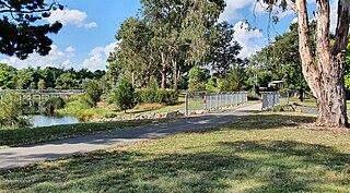
The Sullivans Creek shared path is a 3.7 km (2.3 mi) commuter cycleway in Canberra, Australia. Opened in December 1973, the path was the first off-street cycleway in Canberra and forms a trunk route from which the network extends to the districts of North Canberra, Belconnen and Gungahlin. Transport Canberra's designated cycling routes C1, C3 and C6 all traverse sections of the path, which is by far the busiest cycle route in the city.


