
The Australian Capital Territory (ACT), known as the Federal Capital Territory (FCT) until 1938, is a federal territory of Australia. Canberra, the capital city of Australia, is situated within the territory, and serves as the territory's primate city. It is located in southeastern Australian mainland as an enclave completely within the state of New South Wales. Founded after Federation as the seat of government for the new nation, the territory hosts the headquarters of all important institutions of the Australian Government.

Canberra is the capital city of Australia. Founded following the federation of the colonies of Australia as the seat of government for the new nation, it is Australia's largest inland city and the eighth-largest Australian city overall. The city is located at the northern end of the Australian Capital Territory at the northern tip of the Australian Alps, the country's highest mountain range. As of June 2023, Canberra's estimated population was 466,566.

Namadgi National Park is a protected area in the south-west of the Australian Capital Territory (ACT), bordering Kosciuszko National Park in New South Wales. It lies approximately 40 kilometres (25 mi) southwest of Canberra, and occupies approximately 46 percent of the ACT's land area.
The current flag of the Australian Capital Territory was officially adopted by the Australian Capital Territory Legislative Assembly in 1993.

The Legislative Assembly for the Australian Capital Territory is the unicameral legislature of the Australian Capital Territory (ACT). It sits in the Legislative Assembly Building on Civic Square, close to the centre of the city of Canberra.

The Federal Highway is a highway in New South Wales and the Australian Capital Territory. It is a part of a motorway-standard link between Sydney and Canberra, and is also the main thoroughfare between those cities.

Yarralumla is a large inner south suburb of Canberra, the capital city of Australia. Located approximately 3.5 km (2.2 mi) south-west of the city, Yarralumla extends along the south-west bank of Lake Burley Griffin from Scrivener Dam to Commonwealth Avenue.

The Canberra Deep Space Communication Complex (CDSCC) is a satellite communication station, part of the Deep Space Network of NASA's Jet Propulsion Laboratory (JPL), located at Tidbinbilla in the Australian Capital Territory. Opened in 1965, the complex was used for tracking the Apollo Lunar Module, and along with its two sister stations at Goldstone, California and Madrid, Spain is now used for tracking and communicating with NASA's spacecraft, particularly interplanetary missions. Its DSS-43 antenna is the only antenna on Earth that can send commands to Voyager 2. It is managed in Australia by the Commonwealth Scientific and Industrial Research Organisation (CSIRO) for NASA’s Space Communications and Navigation program (SCaN) at NASA Headquarters in Washington, D.C.

Canberra Airport is an international airport situated in the district of Majura, Australian Capital Territory. It serves Australia's capital city, Canberra, as well as the nearby city of Queanbeyan and regional areas of the Australian Capital Territory and southeastern New South Wales. Located approximately 8 km (5.0 mi) from the city centre, within the North Canberra district, it is the ninth-busiest airport in Australia.

Kingston is the oldest and one of the most densely populated suburbs of Canberra, Australian Capital Territory, Australia. The suburb is named after Charles Cameron Kingston, the former Premier of South Australia and minister in the first Australian Commonwealth Government. It is adjacent to the suburbs of Barton, Fyshwick, Griffith and Manuka. The suburb of Kingston is situated about 4 km from the centre of Canberra.

Commonwealth Avenue is a major road in Canberra, Australian Capital Territory, Australia. It connects Civic with South Canberra. Specifically, it runs between City Hill and Capital Hill.
Uriarra Village is a town in the district of Coree, in the Australian Capital Territory in Australia. It is situated on the western side of the Australian Capital Territory, about 30 minutes from Canberra, established in 1928 at the foothills of the Australian Alps. A nearby area to the north of the border in New South Wales is also called Uriarra.
Transport Canberra & City Services (TCCS) is a directorate of the Government of the Australian Capital Territory of the Australian Capital Territory, responsible for managing roads, footpaths and cycle paths and managing public transport in Canberra including ACTION buses and the Canberra Light Rail through its Transport Canberra division.

The Government of the Australian Capital Territory, also referred to as the Australian Capital Territory Government or ACT Government, is the executive branch of the Australian Capital Territory, one of the territories of Australia. The leader of the party or coalition with the confidence of the Australian Capital Territory Legislative Assembly forms government. Unlike the Australian States and the Northern Territory, the Australian Capital Territory Legislative Assembly directly elects one of their number to be the Chief Minister of the Australian Capital Territory as the head of the Government, rather than being appointed by a Governor or Administrator.
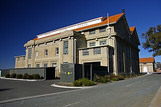
The Kingston Powerhouse is a decommissioned power plant in Canberra, the capital of Australia. It is located in the suburb of Kingston, Australian Capital Territory. It now houses the Canberra Glassworks.

Molonglo Valley is a district in the Australian Capital Territory in Australia. The district is subdivided into divisions (suburbs), sections and blocks and is the newest district of the ACT. The district is planned to consist of thirteen suburbs, planned to contain 33,000 dwellings, with an expected population of between 50,000 and 73,000. To be developed in three stages over more than ten years, the district will contain a principal town centre and a secondary group centre, with residential suburbs located to the south and north of the Molonglo River; located to the west of Lake Burley Griffin.

The Canberra Railway Museum is located at Kingston in the Australian Capital Territory next to Canberra railway station on the Bombala railway line. Since May 2018, Canberra Railway Museum has been the trading name of a not-for-profit company, Capital Region Heritage Rail Limited, established to run the museum, while ACT Heritage Rail Holdings Limited is the company responsible for safeguarding the heritage assets of the museum.

State Circle is a circular road surrounding Capital Hill in the centre of Canberra, Australia's capital city. It is the outermost of the three concentric roads on the hill, with Capital Circle and Parliament Drive located within State Circle. Capital Circle is a bi-directional four-lane road with most intersections being signalised and at-grade. The speed limit is 70 km/h.

Transport in Canberra is provided by private cars, buses, taxis and light rail for travel within the city, while regional rail, air, and long-distance coach services operate for travel beyond Canberra. A vast road network also plays a major role in transport within and beyond the city.

Cycling in Canberra, the capital city of Australia, is a popular means of transportation, sporting and recreational pass time. Commuting in the city is supported by an extensive network of urban cycleways and on-street bicycle lanes. As a city established in the 20th century, Canberra's development was heavily influenced by the automobile for much of its history. The popularity of cycling in the city has increased dramatically in the 21st century with growing awareness of environmental issues, government policy supporting active transport and investment in cycling infrastructure. This has led to the development of a strong cycling culture.
