
Walter Burley Griffin was an American architect and landscape architect. He is known for designing Canberra, Australia's capital city and the New South Wales towns of Griffith and Leeton. He has been credited with the development of the L-shaped floor plan, the carport and an innovative use of reinforced concrete.

Lake Burley Griffin is an artificial lake in the centre of Canberra, the capital of Australia. It was completed in 1963 after the Molonglo River, which ran between the city centre and Parliamentary Triangle, was dammed. It is named after Walter Burley Griffin, the American architect who won the competition to design the city of Canberra.

The Molonglo River, a perennial river that is part of the Murrumbidgee catchment within the Murray–Darling basin, is located in the Monaro and Capital Country regions of New South Wales and the Australian Capital Territory, in Australia.
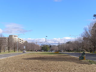
Capital Hill is the location of Parliament House, Canberra, at the south apex of the land axis of the Parliamentary Triangle.
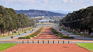
Anzac Parade, a significant road and thoroughfare in the Australian capital Canberra, is used for ceremonial occasions and is the site of many major military memorials.

The National Triangle, which is referred to as the Parliamentary Triangle, is the ceremonial precinct of Canberra, containing some of Australia's most significant buildings. The National Triangle is formed by Commonwealth, Kings and Constitution Avenues. Buildings within the National Triangle have been located and designed intentionally for visual effect, and those of national significance are popular tourist attractions.

Telopea Park is one of the oldest parks in Canberra, Australia. The name of the park is from Walter Burley Griffin's original plan for Canberra where he planned Telopea Park at the end of Sydney Avenue. The park is named after the floral emblem of New South Wales, also known as the Waratah. Griffin planned that the state capital city avenues were terminated with a park named after the generic botanical name for a native plant from that particular state. The park covers 0.079 km².

Kings Park is a park in Canberra, Australia on the shore of Lake Burley Griffin.

Lennox Gardens, a park in Canberra, Australia, lying on the south side of Lake Burley Griffin, close to Commonwealth Avenue Bridge and Albert Hall in the suburb of Yarralumla. Before the construction of Lake Burley Griffin a road ran through the present garden, this road being one of two main crossing points across the Molonglo River. The name of the road was Lennox Crossing from which the present garden takes its name. The northern segment of the road is still present on Acton peninsula. The garden was officially named in 1963. Lennox Crossing was named after David Lennox, an early bridge builder in NSW and Victoria.

Commonwealth Avenue is a major road in Canberra, Australian Capital Territory, Australia. It connects Civic with South Canberra. Specifically, it runs between City Hill and Capital Hill.

Russell is a suburb of Canberra, Australia in the North Canberra district. Russell is one of the smallest suburbs in Canberra, comprising a number of government offices but no private residences. It is probably best known for the headquarters of the Australian Defence Force, which is housed in the Russell Offices complex.
Kings Avenue is a road in Canberra which goes between New Parliament House, across Lake Burley Griffin at the Kings Avenue Bridge, to Russell near the Australian-American Monument..

Parkes Way is a major road in Canberra, Australia, which runs east–west between Kings Avenue and the Glenloch Interchange. At Glenloch Interchange it intersects with William Hovell Drive, Tuggeranong Parkway and Caswell Drive. The road is freeway standard from the Commonwealth Avenue overpass to Glenloch Interchange. Parkes Way is named for prominent Australian federalist, Sir Henry Parkes.

Garema Place is a paved outdoor area in Civic, Canberra, Australia, with a number of shops, restaurants and cafes with outdoor dining. As a central point within the CBD, many community events including protests and festivals are held at the location.

Aspen Island, within Lake Burley Griffin, is a man-made island located in Canberra, Australian Capital Territory, Australia.

The history of Lake Burley Griffin, an artificial body of water in Canberra, the capital of Australia, is a long one. Following its initial design in the 1910s, extensive political disputes occurred until it was finally built in the 1960s.

Pialligo Avenue is a major arterial road in Canberra, the Capital city of Australia. It forms part of the corridor linking the city to Canberra Airport at Pialligo, and Fairbairn. It is also the most direct route from Queanbeyan to the airport precinct. Completed in 2009, a $16 million upgrade of Pialligo Avenue associated with the expansion of the airport saw the road upgraded to dual carriageway standard between its western terminus at the Monaro Highway and the Brindabella Business Park. These works included a grade separated intersection providing access to the redeveloped passenger terminal via a loop road. Substantial upgrades were also carried out at the intersection with Fairbairn Avenue. An estimated 30,000 vehicles use the road daily.

State Circle is a circular road surrounding Capital Hill in the centre of Canberra, Australia's capital city. It is the outermost of the three concentric roads on the hill, with Capital Circle and Parliament Drive located within State Circle. Capital Circle is a bi-directional four-lane road with most intersections being signalised and at-grade. The speed limit is 70 km/h.

Yarra Glen is a major grade separated arterial road in Canberra. It is 3 km (1.9 mi) in length connects South Canberra to the Woden Valley district. It links at its northern end to Adelaide Avenue, and at its southern end to Melrose Drive and Yamba Drive via a large roundabout. It was designed to have no traffic lights nor cross roads on it.
Scott's Crossing Road was a former roadway connecting north and south Canberra, across the Molonglo River floodplain. It was named after John Scott, who was an early settler in the region, and whose homestead was located at its southern end. It was submerged by the filling of Lake Burley Griffin.