
The Murrumbidgee River is a major tributary of the Murray River within the Murray–Darling basin and the second longest river in Australia. It flows through the Australian state of New South Wales and the Australian Capital Territory, descending 1,500 metres (4,900 ft) over 1,485 kilometres (923 mi), generally in a west-northwesterly direction from the foot of Peppercorn Hill in the Fiery Range of the Snowy Mountains towards its confluence with the Murray River near Boundary Bend.

The Sturt Highway is an Australian national highway in New South Wales, Victoria, and South Australia. The Sturt Highway is an important road link for the transport of passengers and freight between Sydney and Adelaide and the regions situated adjacent to the route.
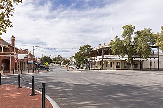
Narrandera until around 1949 also spelled "Narandera", is a town located in the Riverina region of southern New South Wales, Australia. The town lies on the junction of the Newell and Sturt highways, adjacent to the Murrumbidgee River, and it is considered the gateway to the Murrumbidgee Irrigation Area. At the 2016 census, Narrandera had a population of 3,746 people.

The Monaro Highway is a highway in Victoria, New South Wales, and the Australian Capital Territory, in Australia.

The District of Tuggeranong is one of the original eighteen districts of the Australian Capital Territory used in land administration. The district is subdivided into divisions (suburbs), sections and blocks and is the southernmost town centre of Canberra, the capital city of Australia. The district comprises nineteen suburbs and occupies 117 square kilometres (45 sq mi) to the east of the Murrumbidgee River.

Gundagai is a town in New South Wales, Australia. Although a small town, Gundagai is a popular topic for writers and has become a representative icon of a typical Australian country town. Located along the Murrumbidgee River and Muniong, Honeysuckle, Kimo, Mooney Mooney, Murrumbidgee and Tumut mountain ranges, Gundagai is 390 kilometres (240 mi) south-west of Sydney. Until 2016, Gundagai was the administrative centre of Gundagai Shire local government area. In the 2016 census the population of Gundagai was 1,925.

The Naas River, a perennial stream of the Murrumbidgee catchment within the Murray-Darling basin, is located in the Australian Capital Territory, Australia.

Conder is one of three suburbs in the Lanyon Valley in Canberra, Australia. It lies in the district of Tuggeranong. The three suburbs are presently the southernmost suburbs of the city, although the small settlement of Tharwa exists only a short distance further south.

Tharwa is a township within the District of Paddys River, Australian Capital Territory, 35 kilometres (22 mi) south of Canberra, the capital city of Australia. At the 2016 census, Tharwa had a population of 81.

Tuggeranong Parkway is an 11-kilometre-long (6.8 mi) major highway in Canberra, Australia. Often referred to as "The Parkway" by locals, Tuggeranong Parkway links Civic to the southern Canberra metro district of Tuggeranong, and is a bypass road to the Woden Valley-Weston Creek district of Canberra. It also links to the Glenloch Interchange, where roads such as Caswell Drive connect to Belconnen.
The Gudgenby River, a perennial river that is part of the Murrumbidgee catchment within the Murray-Darling basin, is located in the Australian Capital Territory, Australia.
Orroral River, a perennial stream of the Murrumbidgee catchment within the Murray-Darling basin, is located in the Australian Capital Territory, Australia.

Brookton Highway is a 112 kilometres (70 mi) long undivided single carriageway highway in Western Australia, running from the southern Perth suburb of Kelmscott, through Westdale, to the southern Wheatbelt town of Brookton. It is signposted as State Route 40; however, the route and highway continue on far past Brookton, passing through Corrigin, Kondinin, Hyden, Lake King, and finishing at South Coast Highway, just west of Ravensthorpe.

Tharwa Bridge is a four span Allan truss bridge that provides a high-level crossing point across the Murrumbidgee River, allowing traffic between Canberra and Tharwa village. It is the oldest surviving bridge in the Australian Capital Territory.

Lanyon is an historic homestead and grazing property located on the southern outskirts of Canberra in the Australian Capital Territory.

General Holmes Drive is a 5-kilometre (3.1 mi) major divided road located in Sydney, New South Wales, Australia. The road forms part of the M1, the A1, the Sydney Orbital Network, and the Australian Highway 1 network. Initially built in 1919 as a two-lane road and duplicated in 1951, the road partially circumnavigates Sydney Airport with its north-eastern terminus in Mascot, heading west and then south and then south-west, with its south-western terminus with The Grand Parade in Brighton-Le-Sands.
Cuppacumbalong is an historic homestead located near the southern outskirts of Canberra in the Australian Capital Territory. It is also the name of a former 4,000-acre (16 km2) sheep and cattle grazing property that surrounded the homestead near the junction of the Murrumbidgee and Gudgenby Rivers. The word Cuppacumbalong is Aboriginal in origin and means 'meeting of the waters'. One of the property's early owners Leopold Fane De Salis made a noteworthy contribution to political life during colonial times and furthermore, Cuppacumbalong has strong connections to the life of William Farrer, the father of the Australian wheat industry.

Shannons Flat is a locality in the Monaro region of New South Wales, Australia. The town is in the Snowy Monaro Regional Council local government area, sandwiched between the southern border of the Namadgi National Park in the Australian Capital Territory and the Murrumbidgee River. Shannons Flat also adjoins the NSW localities of Yaouk, Bolaro, Murrumbucca, Bredbo and Billilingra. It is about 308 kilometres (191 mi) south west of the state capital, Sydney, and 70 kilometres (40 mi) from the Australian national capital of Canberra. It is just over 40 kilometres (25 mi) north west of the regional centre, Cooma.
Drakeford Drive is an arterial road in the Tuggeranong district of the Australian Capital Territory, a southern suburb of the nation's capital Canberra. The road is named for Arthur Drakeford, Federal Minister for Air and Civil Aviation from 1941 to 1949. The route extends as a divided dual carriageway from the southern end of the Tuggeranong Parkway at Kambah, passing east of Lake Tuggeranong and continues to the suburb of Calwell where it joins Tharwa Drive. The speed limit on Drakeford Drive is 80 km/h (50 mph). In 2012, a large sculpture by artist Alexander Knox, entitled Moth Ascending the Capital was erected on the median strip in Kambah, drawing local criticism about its necessity. In September 2012, a pedestrian overpass over Drakeford Drive was completed, allowing a safer and more convenient crossing for students from Namadgi School in Kambah.
Tourist Drives in Western Australia are routes through areas of scenic or historic significance, designated by route markers with white numbers on a brown shield. Tourist Drives were introduced into Western Australia while Eric Charlton was the state government Minister for Transport in the 1990s. The 28 numbered routes collectively traverse more than 2,000 kilometres (1,200 mi) across the state. In addition to the Tourist Drives, there are unnumbered routes such as the Golden Pipeline Heritage Trail, and local governments may designate and maintain local scenic drives, generally unnamed and unnumbered.