
Federal Highway is a highway in New South Wales and the Australian Capital Territory. It is a part of a motorway-standard link between Sydney and Canberra, and is also the main thoroughfare between those cities.

Barton Highway is a highway in New South Wales and the Australian Capital Territory. It connects Canberra to Hume Highway at Yass, and it is part of the route from Melbourne to Canberra. It is named in honour of Sir Edmund Barton, the first Prime Minister of Australia.

Belconnen is a district in the Australian Capital Territory in Australia. The district is subdivided into 27 divisions (suburbs), sections and blocks.

Lyneham is a suburb of Canberra, Australia in the North Canberra district. It is named after Sir William Lyne, premier of New South Wales from 1899 to 1901. The suburb name was gazetted in 1928, but development did not commence until 1958. The streets of Lyneham are named after artists and people associated with the development of early Canberra.

Charnwood is a suburb in the Belconnen district of Canberra located within the Australian Capital Territory, Australia.

Northbourne Avenue is a major road in Canberra, Australia. It extends from City Hill in the south, to the Federal Highway in the north.

Belconnen is the most inner suburb of the larger district of Belconnen in Canberra, Australia. Sharing its name with the larger district which encapsulates it, the suburb is surrounded with well developed infrastructure, and planning which allows it sunset views from the Brindabellas on its western side. The suburb contains important amenities for the District of Belconnen including the Belconnen Town Centre and Lake Ginninderra as well as its own well populated residential areas. It is bounded by Ginninderra Drive, Aikman Drive, Eastern Valley Way, Belconnen Way and Coulter Drive. It has a number of parks such as Margaret Timpson Park, Eastern Valley Oval and on the foreshores of Lake Ginninberra, Diddams Close Park and John Knight Memorial Park.

Dunlop is a suburb of the Belconnen district of Canberra, located within the Australian Capital Territory, Australia. Dunlop is at the far north-west edge of Canberra, near the border with the state of New South Wales. Approximately 11.6 kilometres (7.2 mi) north-west of the city, Dunlop is next to the suburbs of Fraser, Charnwood and Macgregor. At the edge and within Dunlop lies the Canberra Nature Park called Dunlop Grasslands Nature Reserve, West Belconnen Ponds, Jarramlee Pond and Fassifern Pond which are part of the Ginninderra Catchment.

Tuggeranong Parkway is an 11-kilometre-long (6.8 mi) major highway in Canberra, Australia. Often referred to as "The Parkway" by locals, Tuggeranong Parkway links Civic to the southern Canberra metro district of Tuggeranong, and is a bypass road to the Woden Valley-Weston Creek district of Canberra. It also links to the Glenloch Interchange, where roads such as Caswell Drive connect to Belconnen.

Reid Highway is a 23-kilometre (14 mi) east-west highway and partial freeway in the northern suburbs of Perth, Western Australia, linking North Beach with Middle Swan. As part of State Route 3, it forms half of Perth's outer ring road along with Roe Highway, which it joins onto at its eastern terminus.

Gungahlin Drive Extension (GDE) is a motorway grade road, located in the Belconnen district of Canberra, Australia. It is 8.3 kilometres long and extended the previously existing Gungahlin Drive from the Barton Highway in the district of Gungahlin to the Glenloch Interchange to connect with the Tuggeranong Parkway, Parkes Way, and William Hovell Drive. Early in the planning stages, the GDE was to instead be designated the John Dedman Parkway.

The Ginninderra electorate is one of the five electorates for the unicameral 25-member Australian Capital Territory Legislative Assembly. It elects five members.
Armadale Road is a major road in the south and south east of the Perth Metropolitan Area. It serves three purposes: firstly, providing a main route from Armadale to Fremantle; secondly, connecting Armadale to the Kwinana Freeway; and thirdly, since 2005, connecting it to the Tonkin Highway which ferries traffic to the eastern suburbs, Perth Airport and the Forrestfield and Kewdale industrial areas.

Belconnen Way is a major road in Canberra, Australia. It connects William Hovell Drive and Kingsford Smith Drive in the west to Barry Drive and Fairfax Street, providing access to Civic and the Inner North via Belconnen Town Centre. In addition to being used as an alternate route to the city by commuters from the northern suburbs, it provides the primary connection to the Belconnen Town Center. Along with Barry Drive, Belconnen Way was constructed in stages between 1965 and 1971 as a single carriageway road. It was progressively duplicated as the district's traffic and population grew. A connection to Gungahlin Drive forms the largest signalized and overpass intersection in Canberra, constructed during the Gungahlin Drive Extension works and opening in 2011.
Barry Drive is a major arterial road in Canberra, the capital city of Australia. The road forms part of the most direct route between the city centre, Belconnen Town Centre and Calvary Hospital, as well as providing access to the Australian National University and laboratories of the Commonwealth Scientific and Industrial Research Organisation. Barry Drive defines the boundary between the suburbs of Acton and Turner. The road skirts the foot of Black Mountain and joins Belconnen Way in the Canberra Nature Park. Barry Drive, along with Belconnen Way was constructed between 1965 and 1971 as a single carriageway road. It was progressively upgraded to dual carriageways as traffic volumes grew. As a major transport corridor, many ACTION bus routes transit Barry Drive including cross-city route R4.
Drakeford Drive is an arterial road in the Tuggeranong district of the Australian Capital Territory, a southern suburb of the nation's capital Canberra. The road is named for Arthur Drakeford, Federal Minister for Air and Civil Aviation from 1941 to 1949. The route extends as a divided dual carriageway from the southern end of the Tuggeranong Parkway at Kambah, passing east of Lake Tuggeranong and continues to the suburb of Calwell where it joins Tharwa Drive. The speed limit on Drakeford Drive is 80 km/h (50 mph). In 2012, a large sculpture by artist Alexander Knox, entitled Moth Ascending the Capital was erected on the median strip in Kambah, drawing local criticism about its necessity. In September 2012, a pedestrian overpass over Drakeford Drive was completed, allowing a safer and more convenient crossing for students from Namadgi School in Kambah.

Yarra Glen is a major grade separated arterial road in Canberra. It is 3 km (1.9 mi) in length connects South Canberra to the Woden Valley district. It links at its northern end to Adelaide Avenue, and at its southern end to Melrose Drive and Yamba Drive via a large roundabout. It was designed to have no traffic lights nor cross roads on it.
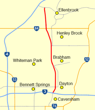
Drumpellier Drive is a north-south road linking Ellenbrook with Reid Highway in the north-eastern suburbs of Perth. The southern section was opened as Lord Street, and was the main link between Ellenbrook and the rest of Perth until the extension of Tonkin Highway north to Gnangara Road. The road corridor has had several proposals put forward for it, including a highway, a bus rapid transit road and a railway. In 2019, a new alignment for Lord Street south of Gnangara Road opened, and it was renamed to Drumpellier Drive, making the naming consistent with the section of road north of Gnangara Road.

Marshall Road is an east-west road in the northern suburbs of Perth, Western Australia. It is continuous with Beach Road.
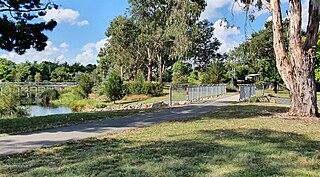
The Sullivans Creek shared path is a 3.7 km (2.3 mi) commuter cycleway in Canberra, Australia. Opened in December 1973, the path was the first off-street cycleway in Canberra and forms a trunk route from which the network extends to the districts of North Canberra, Belconnen and Gungahlin. Transport Canberra's designated cycling routes C1, C3 and C6 all traverse sections of the path, which is by far the busiest cycle route in the city.
