
The Federal Highway is a highway in New South Wales and the Australian Capital Territory. It is a part of a motorway standard link between Sydney and Canberra, and is also the main thoroughfare between those cities.

Canberra Airport, is an international airport situated in the District of Majura, Australian Capital Territory serving Australia's capital city, Canberra, as well as the nearby city of Queanbeyan and regional areas of the Australian Capital Territory, and southeastern New South Wales. Located approximately 8 km (5.0 mi) from the city centre, within the North Canberra district, it is the eighth-busiest airport in Australia.

Pialligo is a rural suburb of Canberra, Australian Capital Territory, Australia. The name Pialligo has been used for the area since at least 1820, and is probably of Aboriginal origin. It was also the name for the parish in the area. Streets in Pialligo are named with Aboriginal words.
Minnesota State Highway 77 (MN 77) is a 11.403-mile-long (18.351 km) highway in Minnesota, which runs from its intersection with 138th Street in Apple Valley and continues north to its northern terminus at its interchange with State Highway 62 in Minneapolis. MN 77 is also known as Cedar Avenue.
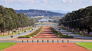
Anzac Parade, a significant road and thoroughfare in the Australian capital Canberra, is used for ceremonial occasions and is the site of many major military memorials.

Northbourne Avenue is a major road in Canberra, Australia. It extends from City Hill in the south to the Federal Highway in the north.
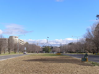
Kings Avenue is a road in Canberra which goes between New Parliament House, across Lake Burley Griffin at the Kings Avenue Bridge, to Russell near the Australian-American Monument..

Parkes Way is a major road in Canberra, Australia, which runs east–west between Kings Avenue and the Glenloch Interchange. At Glenloch Interchange it intersects with William Hovell Drive, Tuggeranong Parkway and Caswell Drive. The road is freeway standard from the Commonwealth Avenue overpass to Glenloch Interchange. Parkes Way is named for prominent Australian federalist, Sir Henry Parkes.

Reid Highway is a 23-kilometre (14 mi) east-west highway and partial freeway in the northern suburbs of Perth, Western Australia, linking North Beach with Middle Swan. As part of State Route 3, it forms half of Perth's outer ring road along with Roe Highway, which it joins onto at its eastern terminus.

Leach Highway is a 23-kilometre (14 mi) east-west arterial highway in the southern suburbs of Perth, Western Australia, primarily linking Kewdale and Perth Airport with the city of Fremantle.

West Coast Highway is an arterial coastal highway located in the western and inner northern suburbs of Perth, Western Australia. It is part of State Route 71, and also Tourist Drive 204 in various coastal parts.
Route 65 is a former state highway in the city of Newark, New Jersey. The route went for 4.12 miles (6.63 km) along Port Street and Doremus Avenue through the industrial districts of the city. Route 65 began at an intersection with U.S. Route 1 and 9 near Newark Liberty International Airport. The route crossed over the New Jersey Turnpike along Port Street until an intersection with Doremus Avenue, where it turned northward for the rest of the distance, terminating at an intersection with U.S. Route 1 and 9 Truck.
State Road 953, locally known as Le Jeune Road, is a 11.735 miles (18.886 km) long north–south street in Miami-Dade County, Florida running a few miles west of central Miami from U.S. Route 1 in Coral Gables to State Road 916 in Opa-locka. It is also known as West 42nd Avenue on the greater Miami grid plan and East 8th Avenue in the Hialeah grid plan.
Armadale Road is a major road in the south and south east of the Perth Metropolitan Area. It serves three purposes: firstly, providing a main route from Armadale to Fremantle; secondly, connecting Armadale to the Kwinana Freeway; and thirdly, since 2005, connecting it to the Tonkin Highway which ferries traffic to the eastern suburbs, Perth Airport and the Forrestfield and Kewdale industrial areas.
Majura Parkway is a 11.5-kilometre-long (7.1 mi) north–south parkway located in the Majura district of the Australian Capital Territory (ACT). It links the northern end to the Federal Highway and Horse Park Drive at the edge of Gungahlin district, and the southern end to the Monaro Highway in Pialligo.
Majura Road is a major arterial road in the eastern rural area of Canberra, the capital city of Australia. The road runs north to south, beginning at a grade separated junction with the Federal Highway 1 km (0.62 mi) inside the border of the Australian Capital Territory. The route followed by the road passes to the east of Mount Majura and mostly rural and industrial properties including the Majura Military Training Area, Mount Majura Winery and a training facility for the Australian Federal Police towards the Majura Park development at Canberra Airport where it ends at Fairbairn Avenue. The road provides a convenient bypass of the city's Inner North from the Gungahlin district to Queanbeyan. Canberra Airport and the Monaro Highway. The route is signposted as an alternative to National Highway 23, the main route between Sydney and the Snowy Mountains and carries considerable volumes of heavy vehicle and tourist traffic.

Ginninderra Drive is a major arterial road in the northern suburbs of Canberra, the capital city of Australia. The road provides an important access corridor to facilities including the Australian Institute of Sport, Canberra Stadium, the University of Canberra and Belconnen Town Centre. It is built to a dual carriageway standard carrying two or three traffic lanes in each direction for most of its length, with a speed limit of 80 km/h (50 mph). A short section from Charnwood to Dunlop is single carriageway with a speed limit of 60 km/h (37 mph). The first section of the road, connecting Lyneham with the new suburb of Evatt opened to traffic in October 1976.
Fairbairn Avenue is a major arterial road in the eastern suburbs of Canberra, the capital city of Australia. The road travels from a junction with Pialligo Avenue near Canberra Airport to the Australian War Memorial, a distance of 4.2 km (2.6 mi). It is the primary access route to the Australian Defence Force Academy, Campbell Park and Mount Ainslie. Fairbairn Avenue carries the Alternative National Highway 23 designation for a short distance between Majura Road and Morshead Drive. This eastern section suffers from heavy traffic congestion during morning and afternoon peak periods and a number of recent upgrades aim to address this. In 2009, works to improve access and traffic flows around the airport precinct saw Fairbairn Avenue duplicated between Pialligo Avenue - where an existing roundabout was replaced with traffic lights - and Morshead Drive, also improving the intersection with Majura Road. A grade separated interchange constructed over Fairbairn Avenue as part of the Majura Parkway project was completed in 2016.

State Circle is a circular road surrounding Capital Hill in the centre of Canberra, Australia's capital city. It is the outermost of the three concentric roads on the hill, with Capital Circle and Parliament Drive located within State Circle. Capital Circle is a bi-directional four-lane road with most intersections being signalised and at-grade. The speed limit is 70 km/h.
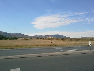
The Majura District is a district of Canberra, with a population of 171 at the 2016 census. It includes Canberra Airport and some farming but little residential development.
