
Fyshwick is a retail and light industrial suburb of Canberra, Australia, east of the South Canberra district. At the 2016 census, Fyshwick had a population of 56.
The history of Canberra details the development of the city of Canberra from the time before European settlement to the city's planning by the Chicago architect Walter Burley Griffin in collaboration with Marion Mahony Griffin, and its subsequent development to the present day.

The Molonglo River is a perennial river that is part of the Murrumbidgee catchment within the Murray–Darling basin. It is located in the Monaro and Capital Country regions of New South Wales and the Australian Capital Territory, in Australia.

Queanbeyan is a city in south-eastern New South Wales, Australia, located adjacent to the Australian Capital Territory in the Southern Tablelands region. Located on the Queanbeyan River, the city is the council seat of the Queanbeyan-Palerang Regional Council. At the 2021 census, the Queanbeyan part of the Canberra–Queanbeyan built-up area had a population of 37,511.

Monaro Highway is a 285-kilometre-long (177 mi) highway in Victoria, New South Wales, and the Australian Capital Territory, in Australia, linking Cann River in Victoria to Canberra in the Australian Capital Territory (ACT) via the Monaro region. From its southern terminus, it follows the nearby Cann River upstream towards the New South Wales border through heavily forested terrain. Within New South Wales (NSW), it makes its way through further forest before reaching the pastures typical of the Monaro. There are multiple towns and villages along the highway, including Bombala, Nimmitabel and Cooma. The terrain within the Monaro is largely hilly, and there are numerous crossings. The road also parallels the former Bombala railway line in several locations. Within the ACT, the road becomes a high volume roadway and serves the southern suburbs of Canberra. The highway has more recently had a grade-separated dual carriageway extension constructed within Canberra, as part of the Eastern Parkway construction project. It is designated part of route M23, and route A23 within Canberra, and route B23 within Victoria and New South Wales, with a concurrency where it also carries route B72 between the two sections of Snowy Mountains Highway.

The Queanbeyan River, a perennial stream that is part of the Molonglo catchment within the Murray–Darling basin, is located in the Monaro and Capital Country regions of New South Wales and the Australian Capital Territory, in Australia. The river is 104 kilometres (65 mi) in length with a catchment area of 96,000 hectares. The Queanbeyan River and the Cotter River meet the potable water supply needs of the Canberra and Queanbeyan region and whose water quality is specifically protected under Federal legislation.

Garema Place is a paved outdoor area in Civic, Canberra, Australia, with a number of shops, restaurants and cafes with outdoor dining. As a central point within the CBD, many community events including protests and festivals are held at the location.
The Seat of Government Acceptance Act 1909 is an Australian Commonwealth Government act, that in conjunction with the Seat of Government Surrender Act 1909 transferred land from the state of New South Wales to the Commonwealth for the creation of the Federal Capital Territory.

The geology of the Australian Capital Territory includes rocks dating from the Ordovician around 480 million years ago, whilst most rocks are from the Silurian. During the Ordovician period the region—along with most of eastern Australia—was part of the ocean floor. The area contains the Pittman Formation consisting largely of quartz-rich sandstone, siltstone and shale; the Adaminaby Beds and the Acton Shale.
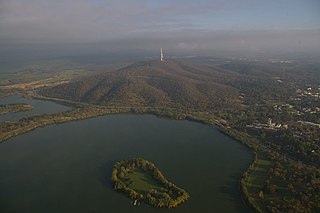
Springbank Island is an island located on Lake Burley Griffin in Canberra, Australian Capital Territory. Springbank Island is named after a former agricultural property that was partially submerged to create Lake Burley Griffin. An elevated part of the former property now comprises the island.

Queanbeyan Parish is a parish of Murray County, New South Wales, a cadastral unit for use on land titles. It covers the city of Queanbeyan. It was originally bounded by the Molonglo River to the north, but is now bounded by the NSW-ACT border in the north and west. Parts of the western area of the parish were transferred to the Australian Capital Territory in 1909, including what are now the Canberra suburbs of Fyshwick, Narrabundah, Kingston, Oaks Estate, Harman and part of Hume.

The Bombala railway line is a branch railway line in the south of New South Wales, Australia. The northern part of it forms part of the main line from Sydney to Canberra, but the southern part is closed. It branches off the Main South line at Joppa Junction, south of Goulburn. The line is used by NSW TrainLink Xplorer services running between Sydney Central and Canberra station.
Environa is a suburb and locality of Queanbeyan, located in the Queanbeyan–Palerang Regional Council, in New South Wales, Australia, west of Jerrabomberra Creek and nearby the New South Wales and Australian Capital Territory border. The development was described as a planned community, but it did not come to fruition. However, Environa has since been allocated as part of the South Jerrabomerra development of Queanbeyan for proposed development, including the proposed developments of Tralee and Poplars.

Carwoola is a locality in the state of New South Wales, Australia. It is immediately to the south of the Kowen district, which is located in the Australian Capital Territory. The Molonglo River passes through the Carwoola area before opening out into the Molonglo Plains. The Kings Highway and Captains Flat Road are the two major through routes. Carwoola is part of the Queanbeyan-Palerang Regional Council and the Southern Tablelands geographic area. The area also roughly aligns with the original Carwoola Parish.

Transport in Canberra is provided by private cars, buses, taxis and light rail for travel within the city, while regional rail, air, and long-distance coach services operate for travel beyond Canberra. A vast road network also plays a major role in transport within and beyond the city.

Beard is a suburb of Canberra in the District of Jerrabomberra, Australian Capital Territory, named after ex-convict Timothy Beard, the first recorded European settler in the vicinity of modern-day Queanbeyan.

Jerrabomberra is a district in the Australian Capital Territory in Australia. It is situated to the southeast of Canberra Central, south of the Molonglo River, east of Woden Valley and north east of Tuggeranong and west of the New South Wales border. It includes the suburbs of Beard, Hume, Oaks Estate and Symonston and the military communications and logistics facility HMAS Harman. At the 2016 census, it had a total population of 1,240, comprising 559 in Symonston, 430 in Hume and 251 in Oaks Estate and Beard At the 2011 census, 13 also lived in Harman. It is named after Jerrabomberra Creek, which runs through it, Jerrabomberra is derived from the Aboriginal word, meaning "afraid of lightning".
Burbong is a former railway station which was located on the Bombala railway line, that leaves the Main Southern railway line at Joppa Junction. It served the Burbong and the surrounding area, which is part of the locality of Carwoola to the east of Queanbeyan in the Monaro Region of New South Wales, Australia.

The Queanbeyan railway bridges over Queanbeyan and Molonglo Rivers are two heritage-listed railway bridges that carry the Bombala railway line in the Queanbeyan-Palerang Region local government area of New South Wales, Australia. Both bridges were built between 1926 and 1927. The westernmost bridge crosses the Queanbeyan River from Queanbeyan to Queanbeyan East at 35.3424°S 149.2317°E, while the easternmost bridge crosses the Molonglo River at Burbong at 35.3371°S 149.3191°E. The two railway bridges are owned by Transport Asset Holding Entity, an agency of the Government of New South Wales. Together, the two bridges were added to the New South Wales State Heritage Register on 2 April 1999.

Canberra, the capital city of Australia, is served by a heavy rail line to New South Wales, and a light rail system. NSW TrainLink regional trains run from Canberra to Sydney.

