Suburbs of Canberra

Last updated

The suburbs of the Australian Capital Territory are organised into a hierarchy of districts, town centres, group centres, local suburbs and other industrial areas and villages. While these divisions have no formal role in the governance or administration of the city, they formed a basis for the planning and development of the city and are significant to the city's commercial and social activities.

Contents

For a complete list, see List of the Australian Capital Territory suburbs

Suburbs

Most suburbs of the Australian Capital Territory are designed around local shops, centrally located within walking distance of the outer parts of the suburb. Consequently, they are generally smaller in size to the suburbs of other cities. A typical Australian Capital Territory suburb is bounded on all sides by major roads, and at the centre, contains local shops, or at least a local store. Some also contain a petrol station, a church, or other community facilities. Many also contain a primary school and a preschool.

As a result of these commercial and community facilities being located in the centre of suburbs, Australian Capital Territory lacks strip shopping along major roads and appears to be 'empty' to most visitors. In the older areas, major roads are lined with houses, and in the newer areas they are typically landscaped with mounds of earth and vegetation to form 'parkways'.

Districts

Australian Capital Territory's districts were developed with the intention of being semi-self-contained satellite cities with an intended population of about 80,000 people. The districts contain town centres which serve as commercial, transport and employment nodes. The districts are separated by nature reserves, and in most cases were designed according to a policy of ridges and valleys where the urban areas were located in valleys, separated by ridges, containing nature parks. There are nineteen districts in the Australian Capital Territory, each is divided into between eight and 25 suburbs, but on average about eighteen. Australian Capital Territory's Plan also contains districts located outside of the urban areas for the purposes of land administration. [2]

Following the transfer of land from the Government of New South Wales to the Commonwealth Government in 1911, eighteen original districts were established in 1966 by the Commonwealth via the gazettal of the Districts Ordinance 1966 No. 5 (Cth) which, after the enactment of the Australian Capital Territory (Self-Government) Act 1988 (Cth), became the Districts Act 1966 No. 5 (ACT). This Act was subsequently repealed by the ACT Government and all districts and the land contained within are now administered subject to the Districts Act 2002 (ACT). [2]

In chronological order of mass development, the districts are:

Selected historical data for the districts of the Australian Capital Territory
Districts Gazettal
date
First settledNumber of
suburbs
Estimated residents at census
2001200620112016 [lower-alpha 1] 2021
Canberra Central North Canberra 12 May 1966 [2] 19282539,438 [3] 42,113 [4] 48,030 [5] 53,002 [6] 61,188 [7]
South Canberra 192724,139 [8] 23,668 [9] 24,154 [10] 27,007 [11] 31,592 [12]
Woden Valley 19631231,336 [13] 31,992 [14] 32,958 [15] 34,760 [16] 39,279 [17]
Belconnen 19672781,701 [18] 84,382 [19] 92,444 [20] 96,049 [21] 106,061 [22]
Jerrabomberra 41,214 [23] [24] [25] [26] [27] 830 [28] [29] [30] [31] [32] 1,241 [33] [34] [35] [36] [37] 1,240 [38] [39] [40] [41] [42] 1,425 [43] [44] [45] [46] [47]
Majura 1347 [48] [49] 232 [50] [51] 246 [52] [53] 174 [54] [55] 299 [56] [57]
Tuggeranong 19741886,346 [58] 87,119 [59] 86,900 [60] 85,154 [61] 89,461 [62]
Weston Creek 1969822,338 [63] 22,127 [64] 22,746 [65] 22,988 [66] 24,630 [67]
Gungahlin 19911823,098 [68] 31,318 [69] 46,971 [70] 71,142 [71] 87,682 [72]
Stromlo 086 [73] 64 [74] 71 [75] 61 [76] 75 [77]
Kowen 030 [78] 49 [79] 34 [80] 38 [81] 25 [82]
Hall 1368 [83] 338 [84] 332 [85] 271 [86] 298 [87]
Coree 1416 [88] 267 [89] 425 [90] 356 [91] [92] 309 [93] [94]
Paddys River 12001–2011: included in Coree150 [95] [96] 158 [97] [98]
Cotter River 00 [99] 0 [100]
Tennent 00 [101] 0 [102]
Rendezvous Creek 00 [101] 0 [102]
Booth 02001–2011: included in Coree31 [103] 64 [104]
Mount Clear 00 [102] 0 [102]
Molonglo Valley 14 October 2010 [105] 201013 planned27 [106] 4,578 [107] 11,435 [108]

City centre

Canberra's CBD - as viewed from Mt Ainslie. Civic from Mt Ainsle.JPG
Canberra's CBD – as viewed from Mt Ainslie.

Canberra's central business district, also known as Civic, is the main commercial centre in Canberra. It is larger than the town centres and contains many Australian Government department offices, large office buildings and retail outlets such as department stores and specialty stores and recreational facilities such as cinemas, bars, nightclubs, restaurants and theatres. The Australian Capital Territory Legislative Assembly is contained within its boundaries; as is the Canberra Theatre and Playhouse, Territory Courts, and the Federal Court.

Town centres

Woden Town Centre, located in the Woden Valley district resembles a miniature CBD. WodenValleyfrmRedHillMay2005.jpg
Woden Town Centre, located in the Woden Valley district resembles a miniature CBD.

Outside Canberra's central business district, there are five town centres within Australian Capital Territory. As well as serving as commercial nodes, town centres also serve as centres of employment. Most contain at least one major Australia government department. For example:

As of 2013, neither the Weston Creek Centre nor the Gungahlin Town Centre contain any substantive Australian government department head office.

Town centres also provide services such as mechanical workshops, gyms, pubs and clubs, cinemas, restaurants and fast food outlets, petrol stations and car dealerships. They also usually contain a public library, police station and a community centre. The Woden Town Centre has high rise office buildings and resembles a 'mini city centre'.

Group centres

Dickson Centre is one of the largest group centres in Canberra. Dickson shops May 2020.jpg
Dickson Centre is one of the largest group centres in Canberra.

Group centres are commercial and community centres smaller than town centres but larger than local shops which are designed to serve a "group" of suburbs – typically about four or five. A typical group centre contains such local commercial facilities such as a supermarket, a petrol station, specialty stores such as a pharmacy, hairdresser, butcher, video store, baker, deli, health food store, betting agency and medical centre. Some larger group centres may also contain banks, a few restaurants and fast food outlets. They will typically also contain recreational and social facilities such as a swimming pool, church, and a tavern or club. These are intended to provide "weekly shopping" type services to the residents of adjoining suburbs.

Industrial areas

The suburbs of Mitchell, Fyshwick and Hume are Australian Capital Territory's industrial areas and are located away from suburbs. While they are the location of light industry (Australian Capital Territory has no heavy industries), they also contain a large number of retail outlets such as furniture stores, hardware stores, car dealerships, bicycle shops, camping stores and wholesale outlets.

Villages

The Australian Capital Territory also contains a number of smaller villages located outside the urban area. Historically some of these are farming or forestry villages and some were damaged or destroyed in the fires of January 2003. The village closest to the urban area is Hall which is located just past Belconnen near the New South Wales border.

See also

Notes

  1. Population for the 2016 census is from Statistical Area Level 3 (SA3) measurements – while earlier census population area counts in this table may have used different boundaries or area levels

Related Research Articles

<span class="mw-page-title-main">Belconnen</span> Place in Australian Capital Territory

Belconnen is one of the original eighteen districts of the Australian Capital Territory, used in land administration. The district is subdivided into 27 divisions (suburbs), sections and blocks.

<span class="mw-page-title-main">Tuggeranong</span> Place in Australian Capital Territory

Tuggeranong is one of the original eighteen districts of the Australian Capital Territory used in land administration. The district is subdivided into divisions (suburbs), sections and blocks and is the southernmost district of the Australian Capital Territory. The district comprises nineteen suburbs and occupies 117 square kilometres (45 sq mi) to the east of the Murrumbidgee River.

<span class="mw-page-title-main">Woden Valley</span> Place in Australian Capital Territory

Woden Valley is one of the original eighteen districts of the Australian Capital Territory used in land administration. The district is subdivided into divisions (suburbs), sections and blocks.

<span class="mw-page-title-main">Gungahlin</span> Place in Australian Capital Territory

Gungahlin is one of the original eighteen districts of the Australian Capital Territory used in land administration. The Gungahlin Region is one of fastest growing regions within Australia. The district is subdivided into divisions (suburbs), sections and blocks. Gungahlin is an Aboriginal word meaning either "white man's house" or "little rocky hill".
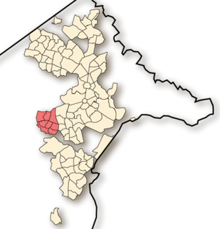
<span class="mw-page-title-main">Weston Creek</span> Place in Australian Capital Territory

Weston Creek is one of the original eighteen districts of the Australian Capital Territory used in land administration. The district is subdivided into divisions (suburbs), sections and blocks. The district comprises eight residential suburbs, situated to the west of the Woden Valley district and approximately 13 kilometres (8.1 mi) southwest of the Canberra City centre. Situated adjacent to the district was the large Stromlo Forest pine plantation until the forest was destroyed by bushfires in 2001 and 2003.

<span class="mw-page-title-main">Waramanga, Australian Capital Territory</span> Suburb of Canberra, Australian Capital Territory

Waramanga is a suburb of Canberra, Australian Capital Territory, Australia in the district of Weston Creek.

<span class="mw-page-title-main">ACT Policing</span> Law enforcement in Canberra, Australia

ACT Policing is the portfolio of the Australian Federal Police (AFP) responsible for providing policing services to the Australian Capital Territory (ACT). The Australian Capital Territory Police was an independent police force responsible for policing the ACT until 19 October 1979, when it was merged with the Commonwealth Police to form the AFP.

<span class="mw-page-title-main">ACTION</span> Public bus operator in Canberra, Australia

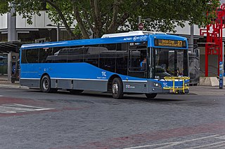
ACTION is a bus operator in Canberra, Australia, and is owned by the Government of the Australian Capital Territory.

<span class="mw-page-title-main">Gungahlin, Australian Capital Territory</span> Suburb of Canberra, Australian Capital Territory

Gungahlin is a suburb in the Canberra, Australia district with the same name; Gungahlin. The postcode is 2912. Gungahlin is the name for the entire district, and also the town centre, but it is also the name of the suburb which Gungahlin Town Centre is in.

<span class="mw-page-title-main">Fadden, Australian Capital Territory</span> Suburb of Canberra, Australian Capital Territory

Fadden is a suburb in the Canberra, Australia district of Tuggeranong. The postcode is 2904. The suburb is named after Sir Arthur Fadden, Prime Minister of Australia briefly in 1941. It was gazetted on 5 August 1975. Its streets are named after Queensland politicians. It is surrounded by Macarthur, Gowrie and Wanniassa. It is bounded by Erindale Drive, the Wanniassa Hills Nature Reserve, Fadden Pine Plantation and Sternberg Crescent.

<span class="mw-page-title-main">Williamsdale, Australian Capital Territory</span> Town in Australian Capital Territory

Williamsdale is a town in the district of Tuggeranong, in the Australian Capital Territory in Australia. Is situated on the northwest side of the Australian Capital Territory border abutting the town of Williamsdale in the Southern Tablelands region of New South Wales, Australia. The Monaro Highway and the former Bombala railway pass through the area. A railway station saw service until 1975. The postcode is 2620.

<span class="mw-page-title-main">Electorates of the Australian Capital Territory</span>

From 2016, the 25-member unicameral Australian Capital Territory Legislative Assembly is elected from five multi-member electorates, with five seats per electorate.

<span class="mw-page-title-main">Canberra Central</span> Place in Australian Capital Territory

Canberra Central is one of the original eighteen districts of the Australian Capital Territory used in land administration consisting of both the subdivisions of North Canberra and South Canberra. The district is subdivided into divisions (suburbs), sections and blocks. The district of Canberra Central lies entirely within the bounds of the city of Canberra, the capital city of Australia.

<span class="mw-page-title-main">Molonglo Valley</span> Place in Australian Capital Territory

Molonglo Valley is one of the nineteen districts of the Australian Capital Territory used in land administration, and the only district that was not created in 1966. The district is subdivided into divisions (suburbs), sections and blocks and is the newest district of the ACT. The district is planned to consist of thirteen suburbs, planned to contain 33,000 dwellings, with an expected population of between 50,000 and 73,000. To be developed in three stages over more than ten years, the district will contain a principal town centre and a secondary group centre, with residential suburbs located to the south and north of the Molonglo River; located to the west of Lake Burley Griffin.

<span class="mw-page-title-main">Demographics of Canberra</span>

Canberra is Australia's capital and its largest inland city. At the 2016 census, it had 395,790 residents. This amounted to only 1.7% of Australia's population. The population density for Canberra is 443.5 people per sq kilometre.

<span class="mw-page-title-main">2016 Australian Capital Territory general election</span>

A general election for the Australian Capital Territory Legislative Assembly was held on Saturday, 15 October 2016.

<span class="mw-page-title-main">Jerrabomberra (district)</span> Place in Australian Capital Territory

Jerrabomberra is one of the original 18 districts of the Australian Capital Territory. It is situated to the southeast of Canberra Central, south of the Molonglo River, east of Woden Valley and north east of Tuggeranong and west of the New South Wales border. It includes the suburbs of Beard, Hume, Oaks Estate and Symonston and the military communications and logistics facility HMAS Harman. At the 2016 census, it had a total population of 1,240, comprising 559 in Symonston, 430 in Hume and 251 in Oaks Estate and Beard At the 2011 census, 13 also lived in Harman. It is named after Jerrabomberra Creek, which runs through it, Jerrabomberra is derived from the Aboriginal word, meaning "afraid of lightning".

R4 (Canberra) Bus route in Canberra, Australia

Route R4 is a main cross-city bus route in Canberra, Australia operated by ACTION between Belconnen, City, Woden Town Centre and Tuggeranong.

<span class="mw-page-title-main">2024 Australian Capital Territory general election</span>

The 2024 Australian Capital Territory general election will be held on or before Saturday the 19th of October 2024 to elect all 25 members of the unicameral ACT Legislative Assembly.

References

  1. "Archived copy" (PDF). Archived from the original (PDF) on 31 January 2022. Retrieved 31 January 2022.{{cite web}}: CS1 maint: archived copy as title (link)
  2. 1 2 3 "Districts Act 1966 Notes". Australian Capital Territory Repealed Acts. AustLII. 2002. Retrieved 18 December 2013.
  3. Australian Bureau of Statistics (9 March 2006). "North Canberra (SSD)". 2001 Census QuickStats. Retrieved 20 December 2013. OOjs UI icon edit-ltr-progressive.svg
  4. Australian Bureau of Statistics (25 October 2007). "North Canberra (SSD)". 2006 Census QuickStats. Retrieved 20 December 2013.
  5. Australian Bureau of Statistics (31 October 2012). "North Canberra (SA3)". 2011 Census QuickStats. Retrieved 20 December 2013. OOjs UI icon edit-ltr-progressive.svg
  6. Australian Bureau of Statistics (27 June 2017). "North Canberra". 2016 Census QuickStats. OOjs UI icon edit-ltr-progressive.svg
  7. Australian Bureau of Statistics (28 June 2022). "North Canberra". 2021 Census QuickStats. Retrieved 12 July 2022. OOjs UI icon edit-ltr-progressive.svg
  8. Australian Bureau of Statistics (9 March 2006). "South Canberra (SSD)". 2001 Census QuickStats. Retrieved 20 December 2013. OOjs UI icon edit-ltr-progressive.svg
  9. Australian Bureau of Statistics (25 October 2007). "South Canberra (SSD)". 2006 Census QuickStats. Retrieved 20 December 2013.
  10. Australian Bureau of Statistics (31 October 2012). "South Canberra (SA3)". 2011 Census QuickStats. Retrieved 20 December 2013. OOjs UI icon edit-ltr-progressive.svg
  11. Australian Bureau of Statistics (27 June 2017). "South Canberra". 2016 Census QuickStats. OOjs UI icon edit-ltr-progressive.svg
  12. Australian Bureau of Statistics (28 June 2022). "South Canberra". 2021 Census QuickStats. Retrieved 12 July 2022. OOjs UI icon edit-ltr-progressive.svg
  13. Australian Bureau of Statistics (9 March 2006). "Woden Valley (SSD)". 2001 Census QuickStats. Retrieved 20 December 2013. OOjs UI icon edit-ltr-progressive.svg
  14. Australian Bureau of Statistics (25 October 2007). "Woden Valley (SSD)". 2006 Census QuickStats. Retrieved 20 December 2013.
  15. Australian Bureau of Statistics (31 October 2012). "Woden (SA3)". 2011 Census QuickStats. Retrieved 20 December 2013. OOjs UI icon edit-ltr-progressive.svg
  16. Australian Bureau of Statistics (27 June 2017). "Woden Valley". 2016 Census QuickStats. OOjs UI icon edit-ltr-progressive.svg
  17. Australian Bureau of Statistics (28 June 2022). "Woden Valley". 2021 Census QuickStats. Retrieved 12 July 2022. OOjs UI icon edit-ltr-progressive.svg
  18. Australian Bureau of Statistics (9 March 2006). "Belconnen (SSD)". 2001 Census QuickStats. Retrieved 20 December 2013. OOjs UI icon edit-ltr-progressive.svg
  19. Australian Bureau of Statistics (25 October 2007). "Belconnen (SSD)". 2006 Census QuickStats. Retrieved 20 December 2013.
  20. Australian Bureau of Statistics (31 October 2012). "Belconnen (SA3)". 2011 Census QuickStats. Retrieved 20 December 2013. OOjs UI icon edit-ltr-progressive.svg
  21. Australian Bureau of Statistics (27 June 2017). "Belconnen (SA3)". 2016 Census QuickStats. OOjs UI icon edit-ltr-progressive.svg
  22. Australian Bureau of Statistics (28 June 2022). "Belconnen". 2021 Census QuickStats. Retrieved 12 July 2022. OOjs UI icon edit-ltr-progressive.svg
  23. Australian Bureau of Statistics (9 March 2006). "Jerrabomberra". 2001 Census QuickStats. Retrieved 15 September 2022. OOjs UI icon edit-ltr-progressive.svg
  24. Australian Bureau of Statistics (9 March 2006). "Harman". 2001 Census QuickStats. Retrieved 15 September 2022. OOjs UI icon edit-ltr-progressive.svg
  25. Australian Bureau of Statistics (9 March 2006). "Hume". 2001 Census QuickStats. Retrieved 15 September 2022. OOjs UI icon edit-ltr-progressive.svg
  26. Australian Bureau of Statistics (9 March 2006). "Oaks Estate". 2001 Census QuickStats. Retrieved 15 September 2022. OOjs UI icon edit-ltr-progressive.svg
  27. Australian Bureau of Statistics (9 March 2006). "Symonston". 2001 Census QuickStats. Retrieved 15 September 2022. OOjs UI icon edit-ltr-progressive.svg
  28. Australian Bureau of Statistics (25 October 2007). "Jerrabomberra". 2006 Census QuickStats. Retrieved 15 September 2022.
  29. Australian Bureau of Statistics (25 October 2007). "Harman". 2006 Census QuickStats. Retrieved 15 September 2022.
  30. Australian Bureau of Statistics (25 October 2007). "Hume". 2006 Census QuickStats. Retrieved 15 September 2022.
  31. Australian Bureau of Statistics (25 October 2007). "Oaks Estate". 2006 Census QuickStats. Retrieved 15 September 2022.
  32. Australian Bureau of Statistics (25 October 2007). "Symonston". 2006 Census QuickStats. Retrieved 15 September 2022.
  33. Australian Bureau of Statistics (31 October 2012). "Jerrabomberra". 2011 Census QuickStats. Retrieved 15 September 2022. OOjs UI icon edit-ltr-progressive.svg
  34. Australian Bureau of Statistics (31 October 2012). "Harman". 2011 Census QuickStats. Retrieved 15 September 2022. OOjs UI icon edit-ltr-progressive.svg
  35. Australian Bureau of Statistics (31 October 2012). "Hume". 2011 Census QuickStats. Retrieved 15 September 2022. OOjs UI icon edit-ltr-progressive.svg
  36. Australian Bureau of Statistics (31 October 2012). "Oaks Estate". 2011 Census QuickStats. Retrieved 15 September 2022. OOjs UI icon edit-ltr-progressive.svg
  37. Australian Bureau of Statistics (31 October 2012). "Symonston". 2011 Census QuickStats. Retrieved 15 September 2022. OOjs UI icon edit-ltr-progressive.svg
  38. Australian Bureau of Statistics (27 June 2017). "ACT Remainder - Jerrabomberra". 2016 Census QuickStats. Retrieved 15 September 2022. OOjs UI icon edit-ltr-progressive.svg
  39. Australian Bureau of Statistics (27 June 2017). "Beard". 2016 Census QuickStats. Retrieved 15 September 2022. OOjs UI icon edit-ltr-progressive.svg
  40. Australian Bureau of Statistics (27 June 2017). "Hume". 2016 Census QuickStats. Retrieved 15 September 2022. OOjs UI icon edit-ltr-progressive.svg
  41. Australian Bureau of Statistics (27 June 2017). "Oaks Estate". 2016 Census QuickStats. Retrieved 15 September 2022. OOjs UI icon edit-ltr-progressive.svg
  42. Australian Bureau of Statistics (27 June 2017). "Symonston". 2016 Census QuickStats. Retrieved 15 September 2022. OOjs UI icon edit-ltr-progressive.svg
  43. Australian Bureau of Statistics (28 June 2022). "ACT Remainder - Jerrabomberra". 2021 Census QuickStats. Retrieved 15 September 2022. OOjs UI icon edit-ltr-progressive.svg
  44. Australian Bureau of Statistics (28 June 2022). "Beard". 2021 Census QuickStats. Retrieved 15 September 2022. OOjs UI icon edit-ltr-progressive.svg
  45. Australian Bureau of Statistics (28 June 2022). "Hume". 2021 Census QuickStats. Retrieved 15 September 2022. OOjs UI icon edit-ltr-progressive.svg
  46. Australian Bureau of Statistics (28 June 2022). "Oaks Estate". 2021 Census QuickStats. Retrieved 15 September 2022. OOjs UI icon edit-ltr-progressive.svg
  47. Australian Bureau of Statistics (28 June 2022). "Symonston". 2021 Census QuickStats. Retrieved 15 September 2022. OOjs UI icon edit-ltr-progressive.svg
  48. Australian Bureau of Statistics (9 March 2006). "Majura". 2001 Census QuickStats. Retrieved 15 September 2022. OOjs UI icon edit-ltr-progressive.svg
  49. Australian Bureau of Statistics (9 March 2006). "Pialligo". 2001 Census QuickStats. Retrieved 15 September 2022. OOjs UI icon edit-ltr-progressive.svg
  50. Australian Bureau of Statistics (25 October 2007). "Majura". 2006 Census QuickStats. Retrieved 15 September 2022.
  51. Australian Bureau of Statistics (25 October 2007). "Pialligo". 2006 Census QuickStats. Retrieved 15 September 2022.
  52. Australian Bureau of Statistics (31 October 2012). "Majura". 2011 Census QuickStats. Retrieved 15 September 2022. OOjs UI icon edit-ltr-progressive.svg
  53. Australian Bureau of Statistics (31 October 2012). "Pialligo". 2011 Census QuickStats. Retrieved 15 September 2022. OOjs UI icon edit-ltr-progressive.svg
  54. Australian Bureau of Statistics (27 June 2017). "ACT Remainder - Majura". 2016 Census QuickStats. Retrieved 15 September 2022. OOjs UI icon edit-ltr-progressive.svg
  55. Australian Bureau of Statistics (27 June 2017). "Pialligo". 2016 Census QuickStats. Retrieved 15 September 2022. OOjs UI icon edit-ltr-progressive.svg
  56. Australian Bureau of Statistics (28 June 2022). "ACT Remainder - Majura". 2021 Census QuickStats. Retrieved 15 September 2022. OOjs UI icon edit-ltr-progressive.svg
  57. Australian Bureau of Statistics (28 June 2022). "Pialligo". 2021 Census QuickStats. Retrieved 15 September 2022. OOjs UI icon edit-ltr-progressive.svg
  58. Australian Bureau of Statistics (9 March 2006). "Tuggeranong (SSD)". 2001 Census QuickStats. Retrieved 12 July 2022. OOjs UI icon edit-ltr-progressive.svg
  59. Australian Bureau of Statistics (25 October 2007). "Tuggeranong (SSD)". 2006 Census QuickStats. Retrieved 20 December 2013.
  60. Australian Bureau of Statistics (31 October 2012). "Tuggeranong (SA3)". 2011 Census QuickStats. Retrieved 20 December 2013. OOjs UI icon edit-ltr-progressive.svg
  61. Australian Bureau of Statistics (27 June 2017). "Tuggeranong". 2016 Census QuickStats. OOjs UI icon edit-ltr-progressive.svg
  62. Australian Bureau of Statistics (28 June 2022). "Tuggeranong". 2021 Census QuickStats. Retrieved 12 July 2022. OOjs UI icon edit-ltr-progressive.svg
  63. Australian Bureau of Statistics (9 March 2006). "Weston Creek-Stromlo (SSD)". 2001 Census QuickStats. Retrieved 20 December 2013. OOjs UI icon edit-ltr-progressive.svg
  64. Australian Bureau of Statistics (25 October 2007). "Weston Creek-Stromlo (SSD)". 2006 Census QuickStats. Retrieved 20 December 2013.
  65. Australian Bureau of Statistics (31 October 2012). "Weston Creek (SA3)". 2011 Census QuickStats. Retrieved 20 December 2013. OOjs UI icon edit-ltr-progressive.svg
  66. Australian Bureau of Statistics (27 June 2017). "Weston Creek". 2016 Census QuickStats. OOjs UI icon edit-ltr-progressive.svg
  67. Australian Bureau of Statistics (28 June 2022). "Weston Creek". 2021 Census QuickStats. Retrieved 12 July 2022. OOjs UI icon edit-ltr-progressive.svg
  68. Australian Bureau of Statistics (9 March 2006). "Gungahlin-Hall (SSD)". 2001 Census QuickStats. Retrieved 20 December 2013. OOjs UI icon edit-ltr-progressive.svg
  69. Australian Bureau of Statistics (25 October 2007). "Gungahlin-Hall (SSD)". 2006 Census QuickStats. Retrieved 20 December 2013.
  70. Australian Bureau of Statistics (31 October 2012). "Gungahlin (SA3)". 2011 Census QuickStats. Retrieved 20 December 2013. OOjs UI icon edit-ltr-progressive.svg
  71. Australian Bureau of Statistics (27 June 2017). "Gungahlin". 2016 Census QuickStats. OOjs UI icon edit-ltr-progressive.svg
  72. Australian Bureau of Statistics (28 June 2022). "Gungahlin". 2021 Census QuickStats. Retrieved 12 July 2022. OOjs UI icon edit-ltr-progressive.svg
  73. Australian Bureau of Statistics (9 March 2006). "Stromlo". 2001 Census QuickStats. Retrieved 15 September 2022. OOjs UI icon edit-ltr-progressive.svg
  74. Australian Bureau of Statistics (25 October 2007). "Stromlo". 2006 Census QuickStats. Retrieved 15 September 2022.
  75. Australian Bureau of Statistics (31 October 2012). "Stromlo". 2011 Census QuickStats. Retrieved 15 September 2022. OOjs UI icon edit-ltr-progressive.svg
  76. Australian Bureau of Statistics (27 June 2017). "ACT Remainder - Stromlo". 2016 Census QuickStats. Retrieved 15 September 2022. OOjs UI icon edit-ltr-progressive.svg
  77. Australian Bureau of Statistics (28 June 2022). "ACT Remainder - Stromlo". 2021 Census QuickStats. Retrieved 15 September 2022. OOjs UI icon edit-ltr-progressive.svg
  78. Australian Bureau of Statistics (9 March 2006). "Kowen". 2001 Census QuickStats. Retrieved 15 September 2022. OOjs UI icon edit-ltr-progressive.svg
  79. Australian Bureau of Statistics (25 October 2007). "Kowen". 2006 Census QuickStats. Retrieved 15 September 2022.
  80. Australian Bureau of Statistics (31 October 2012). "Kowen". 2011 Census QuickStats. Retrieved 15 September 2022. OOjs UI icon edit-ltr-progressive.svg
  81. Australian Bureau of Statistics (27 June 2017). "ACT Remainder - Kowen". 2016 Census QuickStats. Retrieved 15 September 2022. OOjs UI icon edit-ltr-progressive.svg
  82. Australian Bureau of Statistics (28 June 2022). "ACT Remainder - Kowen". 2021 Census QuickStats. Retrieved 15 September 2022. OOjs UI icon edit-ltr-progressive.svg
  83. Australian Bureau of Statistics (9 March 2006). "Hall". 2001 Census QuickStats. Retrieved 15 September 2022. OOjs UI icon edit-ltr-progressive.svg
  84. Australian Bureau of Statistics (25 October 2007). "Hall". 2006 Census QuickStats. Retrieved 15 September 2022.
  85. Australian Bureau of Statistics (31 October 2012). "Hall". 2011 Census QuickStats. Retrieved 15 September 2022. OOjs UI icon edit-ltr-progressive.svg
  86. Australian Bureau of Statistics (27 June 2017). "Hall". 2016 Census QuickStats. Retrieved 15 September 2022. OOjs UI icon edit-ltr-progressive.svg
  87. Australian Bureau of Statistics (28 June 2022). "Hall". 2021 Census QuickStats. Retrieved 15 September 2022. OOjs UI icon edit-ltr-progressive.svg
  88. Australian Bureau of Statistics (9 March 2006). "Remainder of ACT". 2001 Census QuickStats. Retrieved 15 September 2022. OOjs UI icon edit-ltr-progressive.svg
  89. Australian Bureau of Statistics (25 October 2007). "Remainder of ACT". 2006 Census QuickStats. Retrieved 15 September 2022.
  90. Australian Bureau of Statistics (31 October 2012). "Remainder of ACT". 2011 Census QuickStats. Retrieved 15 September 2022. OOjs UI icon edit-ltr-progressive.svg
  91. Australian Bureau of Statistics (27 June 2017). "ACT Remainder - Coree". 2016 Census QuickStats. Retrieved 15 September 2022. OOjs UI icon edit-ltr-progressive.svg
  92. Australian Bureau of Statistics (27 June 2017). "Uriarra Village". 2016 Census QuickStats. Retrieved 15 September 2022. OOjs UI icon edit-ltr-progressive.svg
  93. Australian Bureau of Statistics (28 June 2022). "ACT Remainder - Coree". 2021 Census QuickStats. Retrieved 15 September 2022. OOjs UI icon edit-ltr-progressive.svg
  94. Australian Bureau of Statistics (28 June 2022). "Uriarra Village". 2021 Census QuickStats. Retrieved 15 September 2022. OOjs UI icon edit-ltr-progressive.svg
  95. Australian Bureau of Statistics (27 June 2017). "ACT Remainder - Paddys River". 2016 Census QuickStats. Retrieved 15 September 2022. OOjs UI icon edit-ltr-progressive.svg
  96. Australian Bureau of Statistics (27 June 2017). "Tharwa". 2016 Census QuickStats. Retrieved 15 September 2022. OOjs UI icon edit-ltr-progressive.svg
  97. Australian Bureau of Statistics (28 June 2022). "ACT Remainder - Paddys River". 2021 Census QuickStats. Retrieved 15 September 2022. OOjs UI icon edit-ltr-progressive.svg
  98. Australian Bureau of Statistics (28 June 2022). "Tharwa". 2021 Census QuickStats. Retrieved 15 September 2022. OOjs UI icon edit-ltr-progressive.svg
  99. Australian Bureau of Statistics (27 June 2017). "ACT Remainder - Cotter River". 2016 Census QuickStats. Retrieved 15 September 2022. OOjs UI icon edit-ltr-progressive.svg
  100. Australian Bureau of Statistics (28 June 2022). "ACT Remainder - Cotter River". 2021 Census QuickStats. Retrieved 15 September 2022. OOjs UI icon edit-ltr-progressive.svg
  101. 1 2 Australian Bureau of Statistics (27 June 2017). "ACT Remainder - Rendezvous Creek". 2016 Census QuickStats. Retrieved 15 September 2022. OOjs UI icon edit-ltr-progressive.svg
  102. 1 2 3 4 Australian Bureau of Statistics (28 June 2022). "ACT Remainder - Rendezvous Creek". 2021 Census QuickStats. Retrieved 15 September 2022. OOjs UI icon edit-ltr-progressive.svg
  103. Australian Bureau of Statistics (27 June 2017). "ACT Remainder - Booth". 2016 Census QuickStats. Retrieved 15 September 2022. OOjs UI icon edit-ltr-progressive.svg
  104. Australian Bureau of Statistics (28 June 2022). "ACT Remainder - Booth". 2021 Census QuickStats. Retrieved 15 September 2022. OOjs UI icon edit-ltr-progressive.svg
  105. "Search for street and suburb names: Molonglo Valley". Environment and Sustainable Development Directorate . ACT Government. 4 December 2013. Retrieved 22 December 2013.
  106. Australian Bureau of Statistics (31 October 2012). "Molonglo (SA2)". 2011 Census QuickStats. Retrieved 22 December 2013. OOjs UI icon edit-ltr-progressive.svg
  107. Australian Bureau of Statistics (27 June 2017). "Molonglo". 2016 Census QuickStats. OOjs UI icon edit-ltr-progressive.svg
  108. Australian Bureau of Statistics (28 June 2022). "Molonglo". 2021 Census QuickStats. Retrieved 12 July 2022. OOjs UI icon edit-ltr-progressive.svg