The history of Canberra details the development of the city of Canberra from the time before European settlement to the city's planning by the Chicago architect Walter Burley Griffin in collaboration with Marion Mahony Griffin, and its subsequent development to the present day.

Belconnen is a district in the Australian Capital Territory in Australia. The district is subdivided into 27 divisions (suburbs), sections and blocks.

Tuggeranong is a district in the Australian Capital Territory in Australia. The district is subdivided into divisions (suburbs), sections and blocks and is the southernmost district of the Australian Capital Territory. The district comprises nineteen suburbs and occupies 117 square kilometres (45 sq mi) to the east of the Murrumbidgee River.

Woden Valley is a district in the Australian Capital Territory in Australia. The district is subdivided into divisions (suburbs), sections and blocks.

Gungahlin is a district in the Australian Capital Territory, one of fastest growing regions in Australia. The district is subdivided into suburbs, sections and blocks. Gungahlin is an Aboriginal word meaning either "white man's house" or "little rocky hill".

Dunlop is a suburb of the Belconnen district of Canberra, located within the Australian Capital Territory, Australia. Dunlop is at the far north-west edge of Canberra, near the border with the state of New South Wales. Approximately 11.6 kilometres (7.2 mi) north-west of the city, Dunlop is next to the suburbs of Fraser, Charnwood and Macgregor. At the edge and within Dunlop lies the Canberra Nature Park called Dunlop Grasslands Nature Reserve, West Belconnen Ponds, Jarramlee Pond and Fassifern Pond which are part of the Ginninderra Catchment.
Evatt is a suburb in the Belconnen district of Canberra, located within the Australian Capital Territory, Australia. Evatt lies between the suburbs of McKellar, Belconnen, Florey, Melba and Spence.

Weetangera is a suburb in the Belconnen district of Canberra, located within the Australian Capital Territory, Australia. The suburb covers an area of approximately 158 hectares. Located approximately 10 kilometres (6.2 mi) north-west of the city, Weetangera is bounded by Springvale Drive to the south and west, Coulter Drive to the east and Belconnen Way to the north. The Pinnacle Nature Reserve, a Canberra Nature Park is adjacent to the south of the suburb, across Springvale Drive.

Ngunnawal is a suburb in the district of Gungahlin in Canberra, Australia. The suburb is named in tribute to the Ngunnawal people, the original inhabitants of the area. The suburb was gazetted on 24 April 1992. Ngunnawal is adjacent to the suburbs of Nicholls, Casey, Moncrieff, Amaroo and Gungahlin. It is bounded by Gungahlin Drive, Horse Park Drive, Gundaroo Drive and Mirrabei Drive. Ginninderra Creek is situated near Ngunnawal's eastern boundary. The suburb is located approximately 4 km from the Gungahlin Town Centre and about 13 km from the centre of Canberra.

Hall is a town in the district of Hall, in the Australian Capital Territory in Australia. Is situated on the north side of the Australian Capital Territory. At the 2021 census, the village had a population of 298 people. It is surrounded by open country and has a rural appearance. Hall has retained a village character. The town features historic buildings that existed before the establishment of Canberra.

Moncrieff is a suburb in the Gungahlin district of Canberra, the National Capital of Australia. The name was gazetted in April 1991, with initial land releases becoming available to developers in June 2014. It is named after Gladys Moncrieff, an Australian singer of the 1920-1930s musical era who was dubbed 'Australia's Queen of Song'. The suburb is in north Gungahlin, adjacent to the existing suburbs of Ngunnawal and Amaroo and the future suburbs of Taylor and Jacka. The suburb is located approximately 4 km from the Gungahlin Town Centre and 16 km from the centre of Canberra, and is bounded by Mirrabei Drive and Horse Park Drive. It is home to the Moncrieff Community Recreation Park, which was voted the ACT's favourite playground in 2021.
The history of the Australian Capital Territory (ACT) as a separate administrative division began in 1911, when it was transferred from New South Wales to the Australian federal government. The territory contains Australia's capital city Canberra and various smaller settlements. Until 1989, it also administered the Jervis Bay Territory, a small coastal region.

The Ginninderra electorate is one of the five electorates for the unicameral 25-member Australian Capital Territory Legislative Assembly. It elects five members.
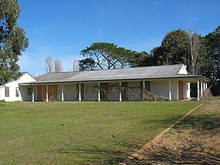
Gold Creek Homestead is a 140-year-old stone and brick building located off Gungahlin Drive in Ngunnawal a north-western suburb of Canberra, Australia. It is adjacent to the Grove Ngunnawal retirement village currently being developed by Lend Lease.

Molonglo Valley is a district in the Australian Capital Territory in Australia. Is the only district that was not created in 1966. The district is subdivided into divisions (suburbs), sections and blocks and is the newest district of the ACT. The district is planned to consist of thirteen suburbs, planned to contain 33,000 dwellings, with an expected population of between 50,000 and 73,000. To be developed in three stages over more than ten years, the district will contain a principal town centre and a secondary group centre, with residential suburbs located to the south and north of the Molonglo River; located to the west of Lake Burley Griffin.
Majura is a district in the Australian Capital Territory in Australia. With a population of 161 at the 2021 census, excluding the suburb of Pialligo, which lies to the south of Canberra Airport. Apart from Pialligo, Majura District includes Canberra Airport, three business parks and some farming but little residential development. The main shopping centre is the Majura Park Shopping Centre.

Strathnairn Homestead in Strathnairn, Australian Capital Territory dates from the 1920s. It was acquired by the Baird family in 1934 who made major additions to the original house. The land was originally part of a grant awarded to explorer Captain Charles Sturt in 1838. The Baird family ran Strathnairn as a sheep and cattle property from 1934 until 1974 when it was resumed by the Commonwealth Government. It was first leased for community arts activities in 1977. Strathnairn Arts Centre continues to provide working spaces and facilities for artists, crafts people and community groups. It also has a café, shop and art gallery.
Macnamara is a suburb in the Belconnen district of Canberra, located within the Australian Capital Territory, Australia. The suburb is part of the West Belconnen / Parkwood cross-border development near the Australian Capital Territory and New South Wales border.
Parkwood is a proposed future suburb of Yass Valley Council in New South Wales, Australia.

