
Belconnen is a district in the Australian Capital Territory in Australia. The district is subdivided into 27 divisions (suburbs), sections and blocks.

Tuggeranong is a district in the Australian Capital Territory in Australia. The district is subdivided into divisions (suburbs), sections and blocks and is the southernmost district of the Australian Capital Territory. The district comprises nineteen suburbs and occupies 117 square kilometres (45 sq mi) to the east of the Murrumbidgee River.
Cook is a suburb of the Belconnen district of Canberra, located within the Australian Capital Territory, Australia. At the 2016 census, Cook had a population of 2,965 people.

Gungahlin is a district in the Australian Capital Territory, one of fastest growing regions in Australia. The district is subdivided into suburbs, sections and blocks. Gungahlin is an Aboriginal word meaning either "white man's house" or "little rocky hill".
Hawker is a suburb of the Belconnen district of Canberra, located within the Australian Capital Territory, Australia.

Macquarie is a residential suburb in the Belconnen district of Canberra, located within the Australian Capital Territory, Australia. Macquarie was gazetted as a division on 22 June 1967 in recognition of Major-General Lachlan Macquarie, a former Governor of New South Wales. Streets in Macquarie are named after contemporaries of Governor Macquarie.
Aranda is a suburb in the district of Belconnen, in the Australian capital city of Canberra. Located at the western foot of Black Mountain and bounded on two sides by nature park, the suburb is characterised by its bush setting. During the planning and development of the suburb, a large proportion of large native trees – predominantly eucalypts – were left in place.

Belconnen is the most inner suburb of the larger district of Belconnen in Canberra, Australia. Sharing its name with the larger district which encapsulates it, the suburb is surrounded with well developed infrastructure, and planning which allows it sunset views from the Brindabellas on its western side. The suburb contains important amenities for the District of Belconnen including the Belconnen Town Centre and Lake Ginninderra as well as its own well populated residential areas. It is bounded by Ginninderra Drive, Aikman Drive, Eastern Valley Way, Belconnen Way and Coulter Drive. It has a number of parks such as Margaret Timpson Park, Eastern Valley Oval and on the foreshores of Lake Ginninberra, Diddams Close Park and John Knight Memorial Park.
Fraser is a suburb in the Belconnen district of Canberra, located within the Australian Capital Territory, Australia. Fraser lies at the north west end of Belconnen.

Giralang is a suburb of the Belconnen district of Canberra, located within the Australian Capital Territory, Australia.
Holt is a suburb in the Belconnen district of Canberra, located within the Australian Capital Territory, Australia. It was gazetted on 2 July 1970 and was named after Harold Holt, Prime Minister of Australia 1966–67. Streets are named after sportsmen and sportswomen.
Kaleen is a suburb in the Belconnen district of Canberra, located within the Australian Capital Territory, Australia. The suburb's name means ‘water’ in the language of the Wiradjuri Aboriginal tribe of the central west region of New South Wales. Kaleen was gazetted as a suburb on 15 January 1974. The streets are named after Australian rivers.

Lawson is a suburb in the Belconnen district of Canberra, located within the Australian Capital Territory, Australia. The suburb is surrounded by Baldwin Drive, Gundaroo Drive and Ginninderra Drive. It lies next to the suburbs of McKellar, Giralang, Kaleen, Bruce and Belconnen.

Hall is a town in the district of Hall, in the Australian Capital Territory in Australia. Is situated on the north side of the Australian Capital Territory. At the 2021 census, the village had a population of 298 people. It is surrounded by open country and has a rural appearance. Hall has retained a village character. The town features historic buildings that existed before the establishment of Canberra.

Franklin is a suburb of Canberra, Australia in the district of Gungahlin. It is named after the novelist Miles Franklin. The streets in Franklin are named after writers. It comprises an area of approximately 256 hectares. It is bounded by Flemington Road to the north and east, Well Station Drive to the south, and Gungahlin Drive to the west. Franklin is mainly a residential area with higher density, mixed-use development along Flemington Road including a local shopping centre and other retail and commercial tenancies.
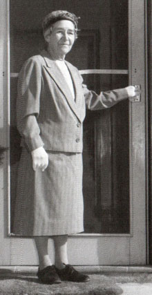
Dame Annie Jean Macnamara, was an Australian medical doctor and scientist, best known for her contributions to children's health and welfare. She was honoured as Dame Commander of the Order of the British Empire in 1935.

Molonglo Valley is a district in the Australian Capital Territory in Australia. Is the only district that was not created in 1966. The district is subdivided into divisions (suburbs), sections and blocks and is the newest district of the ACT. The district is planned to consist of thirteen suburbs, planned to contain 33,000 dwellings, with an expected population of between 50,000 and 73,000. To be developed in three stages over more than ten years, the district will contain a principal town centre and a secondary group centre, with residential suburbs located to the south and north of the Molonglo River; located to the west of Lake Burley Griffin.
Molonglo is a suburb currently under development in the Molonglo Valley district of Canberra, Australian Capital Territory, Australia. The suburb of Molonglo derives its name from an Aboriginal expression meaning "the sound of thunder".
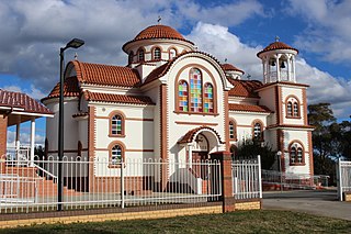
Strathnairn is a suburb in the Belconnen district of Canberra, located within the Australian Capital Territory, Australia. The suburb was gazetted in 2016 as part of the West Belconnen / Parkwood cross-border development near the Australian Capital Territory and New South Wales border.
