Capital Hill Canberra, Australian Capital Territory | |||||||||||||||
---|---|---|---|---|---|---|---|---|---|---|---|---|---|---|---|
Coordinates | 35°18′29″S149°07′28″E / 35.30806°S 149.12444°E | ||||||||||||||
Population | 3 (SAL 2021) [1] | ||||||||||||||
Postcode(s) | 2600 | ||||||||||||||
Elevation | 604 m (1,982 ft) | ||||||||||||||
Location |
| ||||||||||||||
District | South Canberra | ||||||||||||||
Territory electorate(s) | Kurrajong | ||||||||||||||
Federal division(s) | Canberra | ||||||||||||||
|
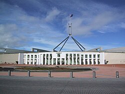
Capital Hill (postcode: 2600) is the location of Parliament House, Canberra, at the south apex of the land axis of the Parliamentary Triangle.
The site was selected as the location of the Capitol in Walter Burley Griffin's Canberra design in 1912, which he envisaged to be "either a general administration structure for popular receptions and ceremony or for housing archives and commemorating Australian Achievements". [2] The proposed building is commemorated in the name of the Capitol Theatre, Manuka. However, Griffin's name for the hill was subsequently changed to Capital Hill.
The Parliament buildings were to be located a little further down the hill towards Lake Burley Griffin at Camp Hill, between Capital Hill and the Provisional Parliament House. Griffin opposed the plan to build a Provisional Parliament House on the lower slopes of Camp Hill, because he considered that it would make it difficult to build the permanent Parliament House on Camp Hill, as the provisional building would have to be demolished. [3]
In fact, in the 1958 and 1964 Holford plans for the Parliamentary Triangle, the site for the New Parliament House was moved to the lake shore, partly for this reason. Holford also reportedly said that a lakeside site would discourage politicians from seeing themselves as superior to ordinary people.
However, in 1974 Parliament voted to move the Parliament to its permanent location on Capital Hill, which it saw as befitting the eminence of the institution. [4] [5] Construction of the new parliament buildings commenced in 1981 and the new building was officially opened by Queen Elizabeth II in 1988, when the Parliament relocated from the old building.
Capital Hill was previously named Kurrajong Hill and is around 2.5 km2, surrounded by a circular road (Capital Circle). Until the construction of the current Parliament House, the hill was covered with scrubby native bushland.
The construction of the current parliament building required removing much of the top half of the hill, and after construction, much of the earth was replaced on top of the building. The surrounding hill is landscaped with native plants, while the soil on top of Parliament House is planted with lawn. However, on the western side of the Hill, a small area of the original native bushland has been preserved.
The streets that go out from Capital Hill are named after Australian capitals, and some of their direction roughly corresponds to the direction of that capital city, Melbourne Avenue, Adelaide Avenue, Perth Avenue, Hobart Avenue and Darwin Avenue with Brisbane Avenue, Sydney Avenue not even being close. The streets which surround the hill in concentric circles are named after increasing spheres of influence with the inner-most circle called Parliament drive and then spanning out to Capital Circle, State Circle, National Circuit, Dominion Circuit and Empire Circuit.
When Griffin drew up his plans in 1912, there was still some optimism that New Zealand might join the Federation of Australia. Griffin's plans included eight avenues radiating out from Capital Hill named after the capitals of the six states, the capital of the Northern Territory and the capital of New Zealand.
Before the name Wellington Avenue was gazetted, it was realised that New Zealand was not going to become part of a Confederation of Australasia and the name was replaced by Canberra Avenue. Griffin planned that the state capital city avenues were terminated with a park named after the generic botanical name for a native plant from that particular site; for example, Telopea Park is named after the waratah, the floral emblem of New South Wales, and is at the end of Sydney Avenue, named after the capital of New South Wales.
The name of the precinct of Manuka is a remnant of Griffin's naming scheme. Another remnant of Griffin's nomenclature was the Wellington Hotel, formerly on the corner of Canberra Avenue and National Circuit, which was demolished and replaced by the hotel known as of 2007 as Rydges Capital Hill Canberra.
The geology of Capital Hill has been studied in great detail. Canberra Formation, calcareous Shale is found in the south west and north east. This overlies middle Silurian Camp Hill Sandstone. The sandstone unconformably overlies the early Silurian Black Mountain Sandstone and State Circle Shale. State Circle Shale is Late Llandovery in a more finely divided time scale and has been dated to 445.7 million years old. The State Circle Shale is composed of laminated shales and siltstone. Black Mountain Sandstone is composed of a white quartz sandstone. The Deakin Fault cuts the south west of state circle. Mount Painter acid volcanoes are to the south west of this fault. [6]
The history of Canberra details the development of the city of Canberra from the time before European settlement to the city's planning by the Chicago architect Walter Burley Griffin in collaboration with Marion Mahony Griffin, and its subsequent development to the present day.
Lake Burley Griffin is an artificial lake in the centre of Canberra, the capital of Australia. It was completed in 1963 after the Molonglo River, which ran between the city centre and Parliamentary Triangle, was dammed. It is named after Walter Burley Griffin, the American architect who won the competition to design the city of Canberra.
Acton is a suburb of Canberra, ACT, Australia. Acton covers an area west of the CBD, bordered by Black Mountain to the west and Lake Burley Griffin in the south. The Australian National University campus covers most of the suburb, though also located in Acton is the National Film and Sound Archive, a branch of the CSIRO and the National Museum of Australia.
Yarralumla is a large inner south suburb of Canberra, the capital city of Australia. Located approximately 3.5 km (2.2 mi) south-west of the city, Yarralumla extends along the south-west bank of Lake Burley Griffin from Scrivener Dam to Commonwealth Avenue.
Black Mountain, also known as Galambary to the Ngunnawal people, is a small mountain with an elevation of 812 metres (2,664 ft) AHD that is situated to the west of the Canberra central business district on the northern shore of Lake Burley Griffin, in the Australian Capital Territory of Australia. Black Mountain is protected from development by the Canberra Nature Park and is predominantly covered in native bushland and is a haven to native wildlife.
Parkes is an inner southern suburb of the Canberra Central district of Canberra, located within the Australian Capital Territory of Australia. Located southeast of the Canberra central business district, Parkes contains the Parliamentary Triangle and many of the national monuments of Australia's capital city.
Forrest is a suburb of Canberra, Australian Capital Territory, Australia. Forrest is named after Sir John Forrest, an explorer, legislator, federalist, Premier of Western Australia, and one of the fathers of the Australian Constitution. Streets in Forrest are named after explorers and governors. According to the Australian Bureau of Statistics Forrest is the second most Socio-Economic advantaged location in Australia after the neighbouring suburb of Barton.
Barton is a suburb of Canberra, Australian Capital Territory, Australia. At the 2021 census, Barton had a population of 1,946 people.
Griffith is an early inner-south suburb of Canberra, Australian Capital Territory, Australia.
Kingston is the oldest and one of the most densely populated suburbs of Canberra, Australian Capital Territory, Australia. The suburb is named after Charles Cameron Kingston, the former Premier of South Australia and minister in the first Australian Commonwealth Government. It is adjacent to the suburbs of Barton, Fyshwick, Griffith and Manuka. The suburb of Kingston is situated about 4 km from the centre of Canberra.
Narrabundah is a leafy, medium density suburb of Canberra, Australian Capital Territory, located in the inner south of the city.
South Canberra, or the Inner South, is a subdivision of Canberra Central in the Australian Capital Territory in Australia.
The National Triangle, which is referred to as the Parliamentary Triangle, is the ceremonial precinct of Canberra, containing some of Australia's most significant buildings. The National Triangle is formed by Commonwealth, Kings and Constitution Avenues. Buildings within the National Triangle have been located and designed intentionally for visual effect, and those of national significance are popular tourist attractions.
Manuka is an area in the Inner South district of Canberra, Australia covering parts of the suburbs of Griffith and Forrest. Manuka Shops, Manuka Oval, Manuka Swimming Pool, and Manuka Circle take their name from the park in the area.
Commonwealth Avenue is a major road in Canberra, Australian Capital Territory, Australia. It connects Civic with South Canberra. Specifically, it runs between City Hill and Capital Hill.
Crace is a suburb of Canberra, Australia in the district of Gungahlin. It was named after Edward Kendall Crace an original settler in the Gungahlin area. Streets in Crace are named after parishes and land divisions from colonial times. It is bounded by the Barton Highway, Gundaroo Drive, Nudurr Drive and Gungahlin Drive. Located in the suburb is the Canberra Nature Park of Gungaderra Grasslands nature reserve. At the 2016 census, it had a population of 4,459.
Kings Avenue is a road in Canberra which goes between New Parliament House, across Lake Burley Griffin at the Kings Avenue Bridge, to Russell near the Australian-American Monument..
The geology of the Australian Capital Territory includes rocks dating from the Ordovician around 480 million years ago, whilst most rocks are from the Silurian. During the Ordovician period the region—along with most of eastern Australia—was part of the ocean floor. The area contains the Pittman Formation consisting largely of quartz-rich sandstone, siltstone and shale; the Adaminaby Beds and the Acton Shale.
The history of Lake Burley Griffin, an artificial body of water in Canberra, the capital of Australia, is highly complex. Following its initial design in the 1910s, extensive political disputes occurred until it was finally built in the 1960s.
The National Capital Authority (NCA) is a statutory authority of the Australian Government that was established to manage the Commonwealth's interest in the planning and development of Canberra as the capital city of Australia.