Lands administrative divisions of Australia

Last updated

.mw-parser-output .legend{page-break-inside:avoid;break-inside:avoid-column}.mw-parser-output .legend-color{display:inline-block;min-width:1.25em;height:1.25em;line-height:1.25;margin:1px 0;text-align:center;border:1px solid black;background-color:transparent;color:black}.mw-parser-output .legend-text{}
No counties, parishes or hundreds.
Former counties, no further divisions.
Counties, divided into hundreds.
Counties, divided into parishes.
Districts, partially divided into suburbs. (Australian Capital Territory only)
Land districts (formerly counties), divided into parishes, and formerly with hundreds.
Counties, divided into parishes, and formerly with hundreds also. (Cumberland County, New South Wales only) Australia cadastral subdivsions counties.png
  No counties, parishes or hundreds.
  Former counties, no further divisions.
  Counties, divided into hundreds.
  Counties, divided into parishes.
  Districts, partially divided into suburbs. (Australian Capital Territory only)
  Land districts (formerly counties), divided into parishes, and formerly with hundreds.
  Counties, divided into parishes, and formerly with hundreds also. (Cumberland County, New South Wales only)

Lands administrative divisions of Australia are the cadastral divisions of Australia for the purposes of identification of land to ensure security of land ownership. Most states term these divisions as counties, parishes, hundreds, and other terms. The eastern states of Queensland, New South Wales, Victoria, and Tasmania were divided into counties and parishes in the 19th century, although the Tasmanian counties were renamed land districts in the 20th century. Parts of South Australia (south-east) and Western Australia (south-west) were similarly divided into counties, and there were also five counties in a small part of the Northern Territory. However South Australia has subdivisions of hundreds instead of parishes, along with the Northern Territory, which was part of South Australia when the hundreds were proclaimed. There were also formerly hundreds in Tasmania. There have been at least 600 counties, 544 hundreds and at least 15,692 parishes in Australia, but there are none of these units for most of the sparsely inhabited central and western parts of the country.

Contents

Counties in Australia have little administrative and no political function, unlike those in England or the United States. Australia instead uses local government areas, including shires, districts, city councils, and municipalities according to the state, as the second-level subdivision.

1891 German map of south-eastern Australia showing many of the divisions. Stielers Handatlas 1891 73.jpg
1891 German map of south-eastern Australia showing many of the divisions.

Some other states were also divided into land divisions and land districts; in the nineteenth century, land districts sometimes served as the region name for parts of the state where counties had not been proclaimed yet. Below these are groups of land parcels known as deposited plans, registered plans or title plans (depending on the state). Queensland has registered plans; New South Wales and Western Australia have deposited plans; while Victoria has certified plans. Land can be identified using the number of this plan of subdivision held with the lands department, rather than with a named unit such as a parish (or both can be used); it has become more common to use only the plan number. Within these are individual land parcels such as lots; in total there are estimated to be about 10.2 million of these in Australia. [1] The various cadastral units appear on certificates of title, which are given volume and folio numbers; these numbers by themselves are sometimes used to identify land parcels, or in combination with the other units. Detailed maps of these divisions have been required since the introduction of the Torrens title system of a central register of land holdings in South Australia in 1858, which spread to the other colonies. While cadastral data since the 1980s has been digitalised, there remain many old maps showing these divisions held in collections of Australian libraries such as the National Library of Australia, [2] as well as in state libraries. [3]

History

1897 cadastral map of the County of Wynyard, New South Wales, showing parishes and property boundaries. Wynyard county NSW 1897.jpg
1897 cadastral map of the County of Wynyard, New South Wales, showing parishes and property boundaries.

Counties were used since the earliest British settlement in Australia, with the County of Cumberland proclaimed by Captain Phillip on 4 June 1788. In 1804 Governor King divided Van Diemen's Land into two counties; Buckingham in the south and Cornwall in the north. [4] The parishes date to the surveys conducted after 1825, with the instructions given to Governor Brisbane on 23 Jun 1825 to divide the colony into counties, hundreds and parishes. At this time there were five counties already proclaimed in New South Wales: Cumberland, Westmoreland, Camden, Argyle and Northumberland. [5] The Nineteen Counties in south-eastern New South Wales were the limits of location of the colony in a period after 1829, with the area outside them originally divided into districts, and later also into counties and parishes. Counties were established soon after the foundation of other Australian colonies.

Many of the counties have English names, often the names of counties in England, such as Devon, Dorset, Cornwall and Kent Counties in Tasmania. Less frequently, some have Aboriginal names such as the County of Yungnulgra in New South Wales, and County of Croajingolong in Victoria.

The use of counties, hundreds and parishes was popular in Australia in the 19th century, with many maps of Australian colonies showing these divisions, [6] and towns and cities often listed in their county. Legal cases referenced counties, and many genealogical records for Australia in the 19th century list the county and parish for location of birth, deaths and marriages. [7] [8] The 1911 Britannica also describes Australian towns and cities as being in their respective county, including most of the capital cities: Melbourne, County of Bourke; Sydney, County of Cumberland; Brisbane, County of Stanley; Adelaide, County of Adelaide; and Hobart, County of Buckingham. However it is not mentioned that Perth was located in the County of Perth, as even by this time county names were infrequently used in Western Australia, where they did not cover all of the settled areas, unlike the other states. Instead the system of land divisions and land districts was used, with most of Perth located in the land districts of Swan, Canning and Cockburn Sound, all in the South West Land Division of Western Australia.

Counties and parishes are also still referenced in property law, and in industrial relations instruments, for example in a New South Wales award, [9] which excludes people from the County of Yancowinna. Similar award examples exist in the other states and territories that have been subdivided into counties. The County of Yancowinna is also the only part of New South Wales which is in a different time zone to the rest of the state, as mentioned in the Australian Standard Time Act of 1987. [10] Counties are also used on paperwork for mortgage securities in banks. Parishes and counties are also mentioned in definitions of electoral districts. [11]

Usage

Population density map, (of white residents) 1921. Evenly divided units of land have little relevance in a country where the population is highly unevenly distributed. AustralianCensus1921.jpg
Population density map, (of white residents) 1921. Evenly divided units of land have little relevance in a country where the population is highly unevenly distributed.

Counties have since gone out of use in Australia, and are rarely used or even known by most of the population today. Part of the reason is that counties are based on the size of land, rather than population, so in a large country where most of the population live in cities on the coast while the countryside has a very low population density, they have little relevance. The counties which contain the capital cities have millions of people, while those in remote areas have a very small population. The County of Adelaide, for instance, has a larger population than all the other counties in South Australia combined. Another reason is that many of the counties' borders follow rivers, having been proclaimed before settlements developed, which means that towns which typically grow up on rivers often find themselves in more than one county. Wangaratta, for instance, is located at the junction of the Ovens and King rivers, and is thus in three counties; Moira, Delatite and Bogong.

Some of the county names live on by being the same name of present-day local government areas, general region names, towns or establishments in the area. For instance, the current Shire of Plantagenet and Shire of Victoria Plains in Western Australia are in the similar area to the County of Plantagenet and County of Victoria, respectively. The modern city of Devonport in Tasmania is located in the County of Devon. Some regions do promote the county name, such as Argyle County, [12] while the County of Cadell (roughly in the Murray Shire area) is still the name for a vineyard [13] and motor lodge in the same area. [14]

By state/territory

Australian Capital Territory

Map of Murray and Cowley counties in New South Wales in 1886, parts of which would eventually become the ACT ACT area Murray County 1886.jpg
Map of Murray and Cowley counties in New South Wales in 1886, parts of which would eventually become the ACT

The land which became the Australian Capital Territory was made from land in the New South Wales counties of Murray and Cowley. This includes four former parishes of Canberra, Yarrolumla, Narrabundah and Gigerline in Murray and 15 former parishes in Cowley, while land in parts of other parishes of these counties also became part of the ACT. Murray lies east of the Murrumbidgee River, with Cowley to the west of the river. Parishes and counties are not currently used in ACT titles. Instead, the Districts Act 1966 divided the ACT into 18 districts: [15] Canberra Central, Woden Valley, Belconnen, Jerrabomberra, Majura, Tuggeranong, Weston Creek, Gungahlin, Stromlo, Kowen, Hall, Coree, Paddys River, Cotter River, Tennent, Rendezvous Creek, Booth and Mount Clear. The parts of these located in Canberra itself are divided into divisions (i.e. suburbs), sections and blocks. For example, the National Library of Australia is located in Section 27, Blocks 4, 5 and 8, Division of Parkes, District of Canberra Central. [16]

New South Wales

The 141 counties of New South Wales, with the original Nineteen Counties shown in pink New South Wales cadastral divisions.png
The 141 counties of New South Wales, with the original Nineteen Counties shown in pink

There are 141 counties and 7,459 parishes within New South Wales. The County of Cumberland, in which Sydney is located, has the largest population. The original Nineteen Counties were the limits of settlement in the early part of the 19th century. Legal documents describe the Lot number, Deposited Plan number, Parish and County. For example, the Sydney Opera House is described as being in Lot 5 in Deposited Plan 775888 at Bennelong Point, Parish of St. James, County of Cumberland, city of Sydney [17] Note that the land administration counties are not the same as the county councils that have been used to administer water and electricity, such as the Goldenfields Water County Council. [18] or Central Tablelands County Council [19] which do not correspond with a land administration county. However, there have been some land administration counties which did have county councils: Cumberland (1945–63), Northumberland (1948–63) and Rous (1940-pres., with trading name of Rous Water [20]

Northern Territory

1886 map showing the small part of the Northern Territory near Darwin subdivided into five counties Northern Territory counties 1886.jpg
1886 map showing the small part of the Northern Territory near Darwin subdivided into five counties

There were only five counties in the Northern Territory, which were divided into hundreds.

Darwin is located in the Hundred of Bagot in the Palmerston County: usually only the hundred name, not the county, is mentioned. This is divided into sections. An example of the way locations are described for Darwin is Darwin International Airport listed as being in "Section 3381, Hundred of Bagot from plan LT089/067A" [21] In Alice Springs, where there are no hundreds or counties, legal documents give the lot number, town and plan number, for example "Lot 8721 Town of Alice Springs, plan(s) LTO96/016" [22]

Queensland

The 319 counties of Queensland in 1901. Queensland cadastral divisions 1901.png
The 319 counties of Queensland in 1901.

There are currently 322 counties in Queensland, subdivided into 5,319 parishes. [23] In the 19th century there were 109 counties, which were later divided into 319 in 1901. The counties which contain the largest population are those on the east coast with the County of Stanley containing Brisbane; the County of Ward containing the Gold Coast and the County of Canning containing Caboolture. Several of these were counties in New South Wales before Queensland became a separate colony in 1859. Legal documents used to list the Lot number, Registered Plan number, County and Parish. For instance, government land near the Brisbane Cricket Ground was described as "Lot 2 on Registered Plan B31553, County of Stanley, Parish of South Brisbane". [24] However, since the digitisation and renumbering of the cadastre of Queensland, parishes are no longer used on title documents. While they have never officially been abolished, they are no longer used except in historical contexts. [25] In 2006, the Queensland Department of Natural Resources, Mines and Water was considering abolishing Counties and Parishes and using only Lot and Plan numbers to identify parcels of land. [26]

South Australia

The 45 counties of South Australia in 1893; later 4 more were proclaimed South Australia cadastral divisions 1893.png
The 45 counties of South Australia in 1893; later 4 more were proclaimed

There are 49 counties in South Australia, mostly in the south-east part of the state. All except 3 of the counties are subdivided into a total of 535 Hundreds. 5 further Hundreds proclaimed between 1853 and 1860 were annulled in 1870. Additionally, 10 Hundreds with names of German origin were renamed after Allied commanders or battles in 1918, 8 of these 10 had been slated for renaming in 1916, but the Aboriginal names suggested at the time were rejected. At various times 3 other Hundred names were proposed but never adopted. All 561 (535+5+10+8+3) current, obsolete or proposed Hundred names are listed in South Australia's official online gazetteer Placenames Online. [27] The city of Adelaide is located in the Hundred of Adelaide in the County of Adelaide. The County of Adelaide held at least 60% of South Australia's population between 1855 and 1921; the figure rose to 70.6% in 1966. [28] All of the existing counties had been proclaimed by 1900, except for Le Hunte (proclaimed 1908), Bosanquet (proclaimed 1913), and Hore-Ruthven (proclaimed 1933). [29] Parcels of land in most residential areas are identified with the Deposited Plan or Filed Plan number with an allotment number, for example: "Allotment 20 in Deposited Plan (DP) 11270". [30] In many rural areas and historically in residential areas, land is described with the Section number, hundred and county, for example "Section 53, Hundred of Borda, County of Carnarvon", [31] or the allotment number within government towns. [32] Sometimes a combination is used, such as "allotment 1 (DP 25326), Hundred of Munno Para". [33] Often only the hundred name is used, [34] not the county, as each hundred has a unique name making the county name redundant.

Tasmania

The 18 land districts (formerly counties) on the island of Tasmania Tasmania cadastral divisions.png
The 18 land districts (formerly counties) on the island of Tasmania

Tasmania is divided into 20 land districts, subdivided into 480 parishes. These include the former 18 counties, which were renamed land districts[ when? ] and retained the same borders. In addition Flinders Island and King Island are now also districts. In the nineteenth and early twentieth century Tasmania had 18 counties. The original counties were divided into hundreds (containing four parishes) but this distinction was seldom observed . [35] Legal documents list Lot numbers, Plan numbers, Parishes and Land Districts. For example, "Lot No. 2 on Plan No. P.14486, Parish of Sorell, Land District of Pembroke" [36]

Victoria

Map of the 37 Victorian counties Victoria cadastral divisions.png
Map of the 37 Victorian counties

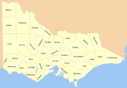
The cadastral divisions of Victoria are called counties and parishes. Victoria is divided into 37 counties, roughly 40 mi × 40 mi (64 km × 64 km) in size, subdivided into 2,914 parishes. [37] Parishes were subdivided into sections of various sizes for sale as farming allotments, or designated as a town and then divided into sections and these subdivided into crown allotments. However, many parishes do not follow county borders, some being located in more than one county.

The county with the largest population is the County of Bourke, which contains Melbourne. Legal documents can describe the county, parish, township (if there is one), section, crown allotment number, and certified plan number. [38] For example: "County of Dalhousie, Parish of Lauriston, being 2 hectares, being Crown Allotment 2, Section 40" [39] or "Parish of Ballarat, County of Grant.. Crown Allotment 29, Section 101, Township of Ballarat East.. as shown on Certified Plan No. 105127" [40]

Western Australia

Map of the 80 land districts of Western Australia in 1909 Western Australia land districts.png
Map of the 80 land districts of Western Australia in 1909

At the start of the 20th century, Western Australia had six land divisions which cover the whole state, divided into 80 land districts. The land districts were further subdivided into locations and lots. Western Australia also had 26 counties, all located in the south-west corner of the state, around Perth. The counties were designated in 1829, the year of the foundation of the Swan River Colony, with Governor Stirling instructing that counties were to be approximately 40 miles square (1,600 square miles). The counties appear on some nineteenth century maps of Australia along with counties in other states, [41] [42] however it was the land districts which were used for cadastral purposes, and were the equivalent of the counties used in the eastern states. Around the end of the twentieth century, legal documents usually wrote them in the order: land district, location, number. For example: "Swan Location 2301". [43] These are further divided into lots. More recently, Western Australia uses only the lot and deposited plan numbers, such as "Lot 853 on Deposited Plan 222626". [44]

See also

Related Research Articles

<span class="mw-page-title-main">Cadastral divisions of Victoria</span> Land administration division of Victoria, Australia

Cadastral divisions in Victoria are called counties, which are further subdivided into parishes and townships, for cadastral or land administration purposes. Cadastral divisions of county, parish and township form the basis for formal identification of the location of any piece of land in the state. There are 37 counties and 2004 parishes and 909 townships. Parishes were subdivided into sections of various sizes for sale as farming allotments, or designated as a town and then divided into sections and these subdivided into crown allotments. However, many parishes do not follow county borders, some being located in more than one county.

Billiatt Conservation Park, formerly the Billiatt National Park, is a protected area in the Australian state of South Australia located in the locality of Sandalwood about 200 kilometres (120 mi) east of the state capital of Adelaide.

<span class="mw-page-title-main">County of Stanley, Queensland</span> Cadastral in Queensland, Australia

The County of Stanley is a cadastral division centred on the city of Brisbane in Queensland, Australia, that is used mainly for the purpose of registering land titles. It was named after Edward Stanley, who was three times British prime minister in the 1850s and 1860s. It is bounded by the Logan River in the south, the Brisbane River at what is now Lake Wivenhoe in the west, the Stanley River at what is now Lake Somerset in the north-west, and Caboolture River in the north. It includes Moreton Island and Stradbroke Island, and extends west to Ipswich's CBD, south to Loganlea and north to Morayfield.

<span class="mw-page-title-main">County of Ward, Queensland</span> Cadastral in Queensland, Australia

The County of Ward is a county in the south-eastern corner of Queensland, Australia. The main urban area within the county is the city of the Gold Coast, and it also extends to include the southern parts of the West Moreton region centred on Beaudesert and Boonah.

<span class="mw-page-title-main">County of Canning</span> Cadastral in Queensland, Australia

The County of Canning is a county in Queensland, Australia. The county consists of almost all of the former Shires of Caboolture, Maroochy and Kilcoy and the former City of Caloundra. Its main urbanised areas are centred on the Sunshine Coast and the areas surrounding Caboolture.

<span class="mw-page-title-main">Lands administrative divisions of New South Wales</span>

For lands administrative purposes, New South Wales is divided into 141 counties, which are further divided into parishes. The counties were first set down in the Colony of New South Wales, which later became the Australian state of New South Wales.

The lands administrative divisions of Western Australia refer to subdivisions of the state of Western Australia for cadastral purposes, most of which have been in place since the 19th century. The state is divided up for this purpose into five land divisions, which in turn are subdivided into land districts, which correspond to counties in other Australian states. These districts are then subdivided further into numbered locations, as well as gazetted townsites. Together, they form part of the lands administrative divisions of Australia.

<span class="mw-page-title-main">Lands administrative divisions of Tasmania</span>

The Lands administrative divisions of Tasmania are the divisions of Tasmania into land districts and parishes for cadastral purposes, which are part of the lands administrative divisions of Australia. There are 20 land districts in Tasmania, although in the early nineteenth century there were several other systems, with 18 or 36 counties and 9 other divisions used, as well as hundreds. The land districts include the 18 former counties of the island of Tasmania which were renamed but retain the same boundaries, plus King Island and Flinders Island. The counties are referenced in the 1911 Encyclopædia Britannica, with Hobart described as being in Buckingham County, Launceston in Cornwall County and Beaconsfield in Devon County. The land districts are used for land titles today, while the Local Government Areas of Tasmania with cities and municipalities are used for political and administrative purposes.

<span class="mw-page-title-main">Lands administrative divisions of Queensland</span>

Lands administrative divisions of Queensland refers to the divisions of Queensland used for the registration of land titles. There are 322 counties, and 5,319 parishes within the state. They are part of the Lands administrative divisions of Australia. Queensland had been divided into 109 counties in the nineteenth century, before the Land Act of 1897 subdivided many of these counties to 319. Some of the eastern counties remained the same, with most of the subdivisions occurring in the west and north. The current counties were named and bounded by the Governor in Council on 7 March 1901.

<span class="mw-page-title-main">County of Churchill, Queensland</span> Cadastral in Queensland, Australia

The County of Churchill is a county in Queensland, Australia. Like all counties in Queensland, it is a non-functional administrative unit, that is used mainly for the purpose of registering land titles. The county lies between 152°E and 153°E longitude, and is centred on the West Moreton region, extending east to the suburbs of Ipswich. The county was named for Lord Randolph Churchill, who was born in 1849, by the Surveyor-General of New South Wales the following year; the area was officially named and bounded by the Governor in Council on 7 March 1901 under the Land Act 1897.

<span class="mw-page-title-main">County of Aubigny</span> Cadastral in Queensland, Australia

The County of Aubigny is a county in Queensland, Australia. Like all counties in Queensland, it is a non-functional administrative unit, that is used mainly for the purpose of registering land titles. The county lies between 151°E and 152°E longitude, and it covers the Toowoomba Region and the Dalby part of the Western Downs Region, The county was named by the Surveyor-General of New South Wales in 1850, possibly to honour the Earl of Arundel who had a long association with the name Aubigny. The area was officially named and bounded by the Governor in Council on 7 March 1901 under the Land Act 1897.

<span class="mw-page-title-main">County of March</span> Cadastral in Queensland, Australia

The County of March is a county in Queensland, Australia. The county consists of the Noosa area, plus the eastern parts of the Gympie and Fraser Coast regions.

<span class="mw-page-title-main">County of Fitzroy, Queensland</span> Cadastral in Queensland, Australia

The County of Fitzroy is a county in Queensland, Australia. Like all counties in Queensland, it is a non-functional administrative unit, that is used mainly for the purpose of registering land titles.

<span class="mw-page-title-main">County of Pelham</span> Cadastral in Queensland, Australia

The County of Pelham is a county in Queensland, Australia, located in the Shire of Banana in Central Queensland. The county is divided into civil parishes. The county was created on 1 September 1855 by royal proclamation under the Waste Lands Australia Act 1846. On 7 March 1901, the Governor issued a proclamation legally dividing Queensland into counties under the Land Act 1897. Its schedule described Pelham thus:

Bounded on the north by the county of Raglan; on the east by the counties of Clinton and Rawbelle; on the south by the county of Rawbelle and the southern watershed of Scoria and Prospect Creeks; and on the west by the eastern watershed of the Dawson River.

<span class="mw-page-title-main">County of Raglan</span> Cadastral in Queensland, Australia

The County of Raglan is a county in Queensland, Australia, located mostly within the Shire of Banana in Central Queensland. The county was first created in January 1854 by the office of the Colonial Secretary of New South Wales. On 7 March 1901, the Governor issued a proclamation legally dividing Queensland into counties under the Land Act 1897. Its schedule described Raglan thus:

Bounded on the south by the southern boundaries of Winterbourne, Callide and Prairie; on the west by the western boundaries of the parishes of Prairie, Spier, Earlsfield, Bundalba, Dundee, Gelobera and Calliungal; on the north by the county of Livingstone; and on the east by the counties of Livingstone, Deas Thompson, and Clinton.

<span class="mw-page-title-main">County of Flinders, Queensland</span> Cadastral in Queensland, Australia

The County of Flinders is a county in Queensland, Australia, located in the Central Queensland region between Gladstone and Bundaberg. The county is divided into civil parishes. It was named for Matthew Flinders who explored the Australian coastline.

<span class="mw-page-title-main">County of Deas Thompson</span> Cadastral in Queensland, Australia

The County of Deas Thompson is a county in Queensland, Australia. It is situated between the cities of Gladstone and Rockhampton. The county is divided into civil parishes. The county was named for Edward Deas Thomson, a New South Wales politician, but the name was misspelt Thompson when applied to the county.

<span class="mw-page-title-main">County of Clive, Queensland</span> Cadastral in Queensland, Australia

The County of Clive is a county in the southern Darling Downs region of Queensland, Australia, on the state border with New South Wales. It was named and bounded by the Governor in Council on 7 March 1901 under the Land Act 1897.

Peachna Conservation Park is a protected area in the Australian state of South Australia located on Eyre Peninsula in the gazetted locality of Tooligie about 100 kilometres (62 mi) north of Port Lincoln and about 30 kilometres (19 mi) south of Lock.

Gowan County, Queensland is a cadastral division of Queensland and a County of the Warrego Land District of southwestern Queensland in Australia.

References

  1. Cadastral systems within Australia Archived 3 September 2006 at the Wayback Machine
  2. National Library of Australia, Cadastral maps
  3. New South Wales Parish map preservation project Archived 27 September 2007 at the Wayback Machine
  4. Founding Documents Archived 3 April 2007 at the Wayback Machine , National Archives of Australia, Colonel Collins' Commission 14 January 1803
  5. State Records NSW, Archives Investigator, Commissioners for Apportioning the Territory
  6. New country and rail road map of New South Wales [cartographic material] : showing rail roads, coach roads, cities, towns &c. 1887. MAP RM 1975.
  7. Louisa Maria Adams. ancestry.com. Retrieved on 7 July 2015.
  8. "Individual Page".
  9. "Minimum Wage". Monthly Labor Review , Vol. 21, No. 6 (December, 1925), p. 97. (JStor, via negotiable paywall)
  10. "Daylight saving time". Archived from the original on 15 March 2007. Retrieved 25 March 2007.
  11. "Burrinjuck". New South Wales Electoral Commission . Retrieved 23 November 2019.
  12. Welcome to the Southern Tablelands of NSW Archived 17 May 2017 at the Wayback Machine . Retrieved 7 July 2015.
  13. Cadell County Vineyard, Barmah. Retrieved 7 July 2015.
  14. Hotel Cadell County Motor Lodge Archived 25 February 2007 at the Wayback Machine . Retrieved 7 July 2015.
  15. ACT map, ACT Planning and Land Authority
  16. ACT Heritage Register Suburbs Archived 10 October 2007 at the Wayback Machine , ACT Department of Territory and Municipal Services
  17. Australia's World Heritage Archived 9 April 2008 at the Wayback Machine , Sydney Opera House, Department of Environment, Water, Heritage and the Arts
  18. Goldenfields Water County Council
  19. Central Tablelands County Council Archived 12 January 2008 at the Wayback Machine
  20. Lismore Source newsletter, Dec. 2004 Who is Rous Water?)
  21. Federal Register of Legislative Instruments Archived 22 July 2008 at the Wayback Machine
  22. alicesprings.nt.gov.au PAWA EASEMENT EXTINGUISHMENT & CREATION — LOT 8721 Archived 9 April 2008 at the Wayback Machine
  23. Queensland government, Cadastral mapping Archived 23 March 2007 at the Wayback Machine
  24. Brisbane Cricket Ground Bill 1993
  25. "Parishes and historical land administration". Government of Queensland . Retrieved 13 February 2023.
  26. Ipswich city council media release Archived 27 September 2007 at the Wayback Machine Plan to change Queensland's land title system
  27. "PlaceNames Online - Search". Archived from the original on 10 January 2014. Retrieved 17 January 2014. select 'feature type' = hundred, click 'search'
  28. Atlas South Australia Archived 23 February 2008 at the Wayback Machine
  29. The Hundreds of South Australia; shows the proclamation date of counties Archived 4 March 2007 at the Wayback Machine
  30. City of Onkaparinga Archived 10 November 2007 at the Wayback Machine , Minutes of the Operations Committee Meeting, 20 September 2005
  31. Votes and Proceedings of the House of Assembly Archived 22 February 2008 at the Wayback Machine , Parliament.sa.gov.au, Tuesday 15 October 2002
  32. Finding plans for a parcel of land Archived 27 October 2007 at the Wayback Machine , Land Services South Australia
  33. NATURAL GAS AUTHORITY ACT 1967 - SCHEDULE 2, South Australian Consolidated Acts, Austlii
  34. NATIONAL PARKS AND WILDLIFE ACT 1972 - SCHEDULE 4, Austlii
  35. Tasmanian electoral commission, Pembroke Archived 28 August 2007 at the Wayback Machine
  36. AIRPORTS REGULATIONS (AMENDMENT) 1998 No. 51 - SCHEDULE, Austlii
  37. landata.vic.gov.au Archived 18 September 2006 at the Wayback Machine , Crown Land Status Online
  38. Crown Survey Requirements Archived 26 January 2008 at the Wayback Machine , land.vic.gov.au
  39. LAND (MISCELLANEOUS) BILL 2004
  40. Ballarat (Sovereign Hill) Land Act 1970 Archived 25 June 2008 at the Wayback Machine . Act No. 7955/1970
  41. Australasia 1882 Society for Promoting Christian Knowledge (Great Britain). Committee of General Literature and Education. NLA MAP RM 941.
  42. Australia 1873 Bartholomew, John, 1831-1893. NLA MAP T 148
  43. City of Perth Restructuring Act 1993 - Sect 32
  44. Electoral District Boundaries, technical descriptions, Boundarieswa.com, 4 August 2003