County of Bogong

Last updated

Bogong
Victoria
Bogong Victoria.png
Location in Victoria
Lands administrative divisions around Bogong:
Denison (NSW) Hume (NSW) Benambra
Delatite Bogong Benambra
Wonnangatta Dargo Dargo

The County of Bogong is one of the 37 counties of Victoria which are part of the cadastral divisions of Australia, used for land titles. It is located south of the Murray River, east of the Ovens River, and west of the Mitta Mitta River. Mount Bogong is located there, the highest mountain in Victoria. The county was proclaimed in 1871.

Cadastral divisions of Victoria land administration division of Victoria, Australia

Cadastral divisions in Victoria are called counties, which are further subdivided into parishes and townships, for cadastral or land administration purposes. Cadastral divisions of county, parish and township form the basis for formal identification of the location of any piece of land in the state. There are 37 counties and 2004 parishes and 909 townships. Parishes were subdivided into sections of various sizes for sale as farming allotments, or designated as a town and then divided into sections and these subdivided into crown allotments. However, many parishes do not follow county borders, some being located in more than one county.

Murray River the longest river in Australia

The Murray River is Australia's longest river, at 2,508 kilometres (1,558 mi) in length. The Murray rises in the Australian Alps, draining the western side of Australia's highest mountains, and then meanders across Australia's inland plains, forming the border between the states of New South Wales and Victoria as it flows to the northwest into South Australia. It turns south at Morgan for its final 315 kilometres (196 mi), reaching the ocean at Lake Alexandrina.

Ovens River river in Victoria, Australia

The Ovens River, a perennial river of the north-east Murray catchment, part of the Murray-Darling basin, is located in the alpine and Hume regions of the Australian state of Victoria.

Contents

Origin of the name

Bogong moth is a native insect of Australia. This was once considered a delicacy by the aborigines who collected the dormant larvae and cooked them. A town, Bogong, in the state of Victoria has been named after the moth. [1]

Bogong moth species of insect

The bogong moth is a temperate species of night-flying moth, notable for its biannual long-distance seasonal migrations towards and from the Australian Alps, similar to the diurnal monarch butterfly. During the autumn and winter it is found in southern Queensland, western New South Wales, western Victoria, and also in South and Western Australia. Adult bogong moths breed and larvae hatch during this period, consuming winter pasture plants during their growth. During the spring, the moths migrate south or east and reside in mountains such as Mount Bogong, where they gregariously aestivate over the summer until their return towards breeding grounds again in the autumn.

Insect Class of invertebrates

Insects or Insecta are hexapod invertebrates and the largest group within the arthropod phylum. Definitions and circumscriptions vary; usually, insects comprise a class within the Arthropoda. As used here, the term Insecta is synonymous with Ectognatha. Insects have a chitinous exoskeleton, a three-part body, three pairs of jointed legs, compound eyes and one pair of antennae. Insects are the most diverse group of animals; they include more than a million described species and represent more than half of all known living organisms. The total number of extant species is estimated at between six and ten million; potentially over 90% of the animal life forms on Earth are insects. Insects may be found in nearly all environments, although only a small number of species reside in the oceans, which are dominated by another arthropod group, crustaceans.

Australia Country in Oceania

Australia, officially the Commonwealth of Australia, is a sovereign country comprising the mainland of the Australian continent, the island of Tasmania, and numerous smaller islands. It is the largest country in Oceania and the world's sixth-largest country by total area. The neighbouring countries are Papua New Guinea, Indonesia, and East Timor to the north; the Solomon Islands and Vanuatu to the north-east; and New Zealand to the south-east. The population of 25 million is highly urbanised and heavily concentrated on the eastern seaboard. Australia's capital is Canberra, and its largest city is Sydney. The country's other major metropolitan areas are Melbourne, Brisbane, Perth, and Adelaide.

Parishes

Parishes within the county:

Barwidgee, Victoria Town in Victoria, Australia

Barwidgee is a rural locality in northeast Victoria, Australia. The nearest town to Barwidgee is Myrtleford about 5.44 km away. Barwidgee is within Alpine Shire.

Bonegilla, Victoria Town in Victoria, Australia

Bonegilla is a bounded rural locality of the City of Wodonga local government area in north-east Victoria, Australia, 10 kilometres (6.2 mi) east of Wodonga, and around 300 kilometres (190 mi) north-east of Melbourne. In the 2016 census, Bonegilla and surrounding area had a population of 693.

Bright, Victoria Town in Victoria, Australia

Bright is a town in northeastern Victoria, Australia, 319 metres above sea level at the southeastern end of the Ovens Valley. At the 2016 census, Bright had a population of 2,406. It is in the Alpine Shire local government area. Its postcode is 3741.

Related Research Articles

Mitta Mitta River river in Australia

Mitta Mitta River, a perennial river and a direct tributary of the Murray River within the Murray-Darling basin, is located in the alpine district of Victoria, Australia.

City of Wodonga Local government area in Victoria, Australia

Wodonga Council is a local government area in the Hume region of Victoria, Australia, located in the north-east part of the state. It covers an area of 433 square kilometres (167 sq mi) and at the 2016 Census, had a population of over 39,000.

Mount Bogong mountain

Mount Bogong,, located in the Alpine National Park and part of the Victorian Alps of the Great Dividing Range, is the highest mountain in Victoria, Australia, at 1,986 metres (6,516 ft) above sea level.

Electoral district of Benambra state electoral district of Victoria, Australia

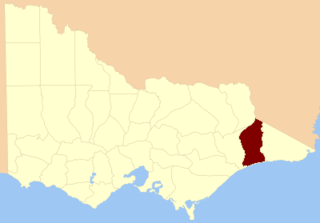
The electoral district of Benambra is one of the electoral districts of Victoria, Australia, for the Victorian Legislative Assembly. It covers an area of 10,037 square kilometres (3,875 sq mi) in north-eastern Victoria, and includes the towns of Baranduda, Barnawartha, Beechworth, Chiltern, Corryong, Eskdale, Kiewa, Mitta Mitta, Mount Beauty, Rutherglen, Tallangatta, Tangambalanga, Tawonga, Wahgunyah, Wodonga and Yackandandah. It lies in the Northern Victoria Region of the upper house, the Legislative Council.

Barnawartha, Victoria Town in Victoria, Australia

Barnawartha is a small town located on the Hume Highway in regional north-east Victoria, Australia, approximately 299 kilometres (186 mi) from Melbourne on the banks of Indigo Creek which runs into the Murray River to the north.

Mitta Mitta, Victoria Town in Victoria, Australia

Mitta Mitta is a small town in the Australian state of Victoria in the Mitta Mitta Valley. It stands on the Omeo Highway and is 415 km from Melbourne, and is located on the Mitta Mitta River not far from Dartmouth Dam. At the 2006 census, Mitta Mitta and the surrounding area had a population of 151. The permanent town population is 39.

County of Delatite Cadastral in Victoria, Australia

The County of Delatite is one of the 37 counties of Victoria which are part of the cadastral divisions of Australia, used for land titles. It is located south west of Ovens River. Wangaratta is partly located in the county, at the northern end.

Tallangatta & District Football League

The Tallangatta and District Football League (TDFL) is an Australian rules football competition in north-east Victoria and the southern border area of Riverina region of the New South Wales. The clubs compete across four competitions, two of which are age restricted.

County of Dalhousie, Victoria Cadastral in Victoria, Australia

The County of Dalhousie is one of the 37 counties of Victoria which are part of the cadastral divisions of Australia, used for land titles. It is located to the north of Melbourne. It is bounded by the Coliban River to the west. The Goulburn River forms part of the boundary to the north-east. Puckapunyal is on its northern edge, and Kilmore and Woodend on its southern edge. The county was proclaimed in 1849.

County of Tanjil Cadastral in Victoria, Australia

The County of Tanjil is one of the 37 counties of Victoria which are part of the cadastral divisions of Australia, used for land titles. It includes the coastal area around the Gippsland Lakes. The Mitchell River is the north-eastern boundary. Before the 1860s, the area was part of the former county of Bruce and part of Haddington.

County of Dargo Cadastral in Victoria, Australia

The County of Dargo is one of the 37 counties of Victoria which are part of the cadastral divisions of Australia, used for land titles. It is located in Gippsland, between the Mitchell River in the west and the Tambo River in the east. Lake King is on the southern edge. It was gazetted in 1871. Earlier maps show the area as being part of a proposed County of Abinger.

County of Tambo, Victoria Cadastral in Victoria, Australia

The County of Tambo is one of the 37 counties of Victoria which are part of the cadastral divisions of Australia, used for land titles. It is located in eastern Gippsland, between the Tambo River in the west, and the Snowy River in the east. It includes Lakes Entrance. Some time earlier maps showed proposed counties of Abinger and Combermere occupying the area.

County of Benambra Cadastral in Victoria, Australia

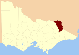
The County of Benambra is one of the 37 counties of Victoria which are part of the cadastral divisions of Australia, used for land titles. It is located between the Mitta Mitta River in the west, and the Murray River to the north and east. The town of Benambra is located near the southern edge. The area of the county roughly corresponds with the Electoral district of Benambra. Corryong is the largest town in the county. The county was proclaimed in 1871.

The Electoral district of Wangaratta was an electoral district of the Victorian Legislative Assembly. It was created in the redistribution of 1904, the Electoral district of Wangaratta and Rutherglen being abolished.

Shire of Chiltern Local government area in Victoria, Australia

The Shire of Chiltern was a local government area located about 280 kilometres (174 mi) north-northeast of Melbourne, the state capital of Victoria, Australia. The shire covered an area of 501.64 square kilometres (193.7 sq mi), and existed from 1862 until 1994.

Shire of Yackandandah Local government area in Victoria, Australia

The Shire of Yackandandah was a local government area about 290 kilometres (180 mi) northeast of Melbourne, the state capital of Victoria, Australia. The shire covered an area of 1,148.75 square kilometres (443.5 sq mi), and existed from 1862 until 1994.

Eskdale, Victoria Town in Victoria, Australia

Eskdale is a small town near the major regional centre of Albury-Wodonga, in Victoria's north. It is situated in the Mitta Valley, near the river's confluence with the Little Snowy Creek, amongst the foothills of Mount Bogong. At the 2016 census, Eskdale and the surrounding area had a population of 242.

Geography of Victoria

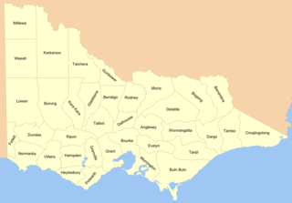
Victoria is the southernmost mainland state of Australia. With an area of 227,594 km², it is Australia's sixth largest state or territory. The State is comparable in size to the US state of Utah or the island of Great Britain. It is bound to the northwest by South Australia, directly north by New South Wales, and also shares a maritime border with Tasmania to the south, across the Bass Strait. Most of Victoria's northern border lies along the Murray River. The eastern half of the state is dominated by the Great Dividing Range and the surrounding uplands, which also to a lesser extent extend far into the west of the state and ease off after The Grampians. By comparison the north and northwest of the state is extremely flat with little prominence. Approximately three quarters of Victoria's population lives on and around the coast of the Port Phillip and Western Port bays, chiefly in Melbourne, in Victoria's South Central region.

Big River (Mitta Mitta River, Victoria) river (tributary of the Mitta Mitta River) in East Gippsland Shire, Victoria, Australia

The Big River, a perennial river of the North-East Murray catchment of the Murray-Darling basin, is located in the East Gippsland and alpine regions of Victoria, Australia. It flows from the northern slopes of Falls Creek in the Australian Alps, joining with the Cobungra River near Anglers Rest to form the Mitta Mitta River.

The Minjambuta were an indigenous Australian tribe of northern Victoria.

References

  1. Physical Map of Australia, special advertising feature of Australia.com on pg 16, National Geographic magazine, May 2006, Washington DC

See also

Coordinates: 36°15′S146°50′E / 36.250°S 146.833°E / -36.250; 146.833

Geographic coordinate system Coordinate system

A geographic coordinate system is a coordinate system that enables every location on Earth to be specified by a set of numbers, letters or symbols. The coordinates are often chosen such that one of the numbers represents a vertical position and two or three of the numbers represent a horizontal position; alternatively, a geographic position may be expressed in a combined three-dimensional Cartesian vector. A common choice of coordinates is latitude, longitude and elevation. To specify a location on a plane requires a map projection.