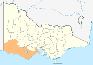
The Shire of Colac Otway is a local government area in the Barwon South West region of Victoria, Australia, located in the south-western part of the state. It covers an area of 3,438 square kilometres (1,327 sq mi) and in June 2018 had a population of 21,503. It includes the towns of Apollo Bay, Beeac, Beech Forest, Birregurra, Colac, Cressy, Forrest, Johanna, Kennett River, Lavers Hill, Warrion and Wye River. It came into existence on 23 September 1994 through the amalgamation of the local government areas of City of Colac, Shire of Colac, part of the Shire of Otway and part of the Shire of Heytesbury.

Forrest is a small rural township in the Otway Ranges, Victoria, Australia. At the 2016 census, Forrest and the surrounding area had a population of 230.
The electoral district of Polwarth is an electoral district of the Victorian Legislative Assembly. It is located in south-west rural Victoria, west of Geelong, and covers the Colac and Corangamite local government areas (LGA), parts of the Moyne, Golden Plains and Surf Coast LGAs, and slivers of the Ararat and Greater Geelong LGAs, running along the Great Ocean Road taking in Anglesea, Cape Otway, Peterborough, Aireys Inlet, Lorne, Wye River, Apollo Bay and Port Campbell, covering the inland towns of Winchelsea, Colac, Camperdown and Terang along the Princes Highway, and Inverleigh, Cressy, Lismore and Mortlake on the Hamilton Highway, and finally, includes the Otway Ranges and Lake Corangamite.

The County of Grenville is one of the 37 counties of Victoria which are part of the cadastral divisions of Australia, used for land titles. It is located to the north-east of Lake Corangamite and includes Cressy. Ballarat is on its north-eastern edge. The boundary to the east is the Yarrowee River, and to the south part of the Barwon River. Colac is on its southern edge. The county was proclaimed in 1849.

The Electoral district of Colac was an electoral district of the Victorian Legislative Assembly, one of the inaugural districts of the first Assembly in 1856.

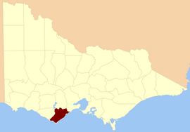
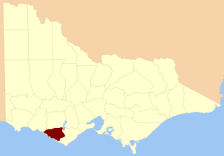
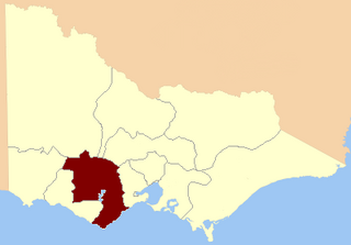
The Shire of Colac was a local government area about 150 kilometres (93 mi) west-southwest of Melbourne, the state capital of Victoria, Australia. The shire covered an area of 1,458.2 square kilometres (563.0 sq mi), and existed from 1859 until 1994.
The Shire of Heytesbury was a local government area about 200 kilometres (124 mi) west-southwest of Melbourne, the state capital of Victoria, Australia. The shire covered an area of 1,558.39 square kilometres (601.7 sq mi), and existed from 1895 until 1994.

The Shire of Otway was a local government area about 190 kilometres (118 mi) southwest of Melbourne, the state capital of Victoria, Australia. The shire covered an area of 1,906.94 square kilometres (736.3 sq mi), and existed from 1919 until 1994.

The City of Colac was a local government area about 150 kilometres (93 mi) west-southwest of Melbourne, the state capital of Victoria, Australia. The city covered an area of 10.88 square kilometres (4.2 sq mi), and existed from 1938 until 1994. Its area was surrounded by the separate and largely rural Shire of Colac.

The Shire of Winchelsea was a local government area about 110 kilometres (68 mi) southwest of Melbourne, the state capital of Victoria, Australia. The shire covered an area of 1,294 square kilometres (499.6 sq mi), and existed from 1860 until 1994.

The Colac & District Football Netball League (CDFNL) is a minor country football league based in the South West of Victoria in the city of Colac. The CDFNL has 10 clubs, all located in the Colac Otway Shire, with the exception of Lorne, which falls within the Surf Coast Shire. The competition incorporates the two sports of Australian rules football and netball.
The County of Heytesbury is one of the 37 counties of Victoria which are part of the cadastral divisions of Australia, used for land titles. The county is in the Western District of Victoria bounded by the Gellibrand River in the east and the Hopkins River in the west. In the north, the county was bounded approximately by the existing road, now the Princes Highway. Larger towns include Camperdown and Cobden. The county was proclaimed in 1849.

Polwarth, Ripon, Hampden and South Grenville was an electoral district of the Legislative Assembly in the Australian state of Victoria from 1856 to 1859. It was based in western Victoria.

Polwarth and South Grenville was an electoral district of the Legislative Assembly in the Australian state of Victoria from 1859 to 1889. It was based in western Victoria.
The Electoral district of Ripon, Hampden, Grenville and Polwarth was one of the original sixteen electoral districts of the old unicameral Victorian Legislative Council of 1851 to 1856. Victoria being a colony in Australia at the time.
The Forrest railway line is a former branch railway in Victoria, Australia. It branched off the Warrnambool railway line at Birregurra, and ran through the foothills of the Otway Ranges to the town of Forrest.
The Barwon South West is an economic rural region located in the southwestern part of Victoria, Australia. The Barwon South West region stretches from the tip of the Queenscliff Heads to the border of South Australia. It is home to Victoria’s largest provincial centre, Geelong and the major centres of Aireys Inlet, Apollo Bay, Camperdown, Colac, Hamilton, Lorne, Port Campbell, Port Fairy, Portland, Torquay and Warrnambool. It draws its name from the Barwon River and the geographic location of the region in the state of Victoria.
Norman Houghton is a historian and archivist in Geelong, Victoria, who has published over 30 books, many focusing on timber tramways and sawmills of the Otway and Wombat Forests of Western Victoria, Australia. Most of his works have been self-published, while he has provided numerous articles to the newsletter and journal of the Light Railway Research Society of Australia
Tanybryn is a rural locality in Victoria, Australia, situated in the Shire of Colac Otway. In the 2016 census, Tanybryn had a population of 19.