
The City of Greater Bendigo is a local government area in Victoria, Australia, located in the central part of the state. It covers an area of 3,000 square kilometres (1,200 sq mi) and, in June 2021, had a population of 123,632. It includes the city of Bendigo and the towns of Axedale, Elmore, Heathcote, Marong, Raywood and Strathfieldsaye. It was formed in 1994 from the amalgamation of the former City of Bendigo with the Borough of Eaglehawk, Shire of Strathfieldsaye, Shire of Huntly, Rural City of Marong and parts of the Shire of McIvor. It is the state’s third largest economy base and is considered a service and infrastructure centre for north central Victoria. The city is surrounded by 40,000 hectares of regional, state and national parkland.

The County of Bogong is one of the 37 counties of Victoria which are part of the cadastral divisions of Australia, used for land titles. It is located south of the Murray River, east of the Ovens River, and west of the Mitta Mitta River. Mount Bogong is located there, the highest mountain in Victoria. The county was proclaimed in 1871.

The Anglican Diocese of Bendigo is a diocese of the Anglican Church of Australia. It is situated in the Bendigo region of the state of Victoria, Australia. Its geographic remit extends from that part of Victoria that lies north of the Great Dividing Range and west of the Goulburn River to the border with the state of South Australia. The diocesan cathedral is St Paul's Cathedral, Bendigo. The diocese was separated from the Diocese of Melbourne in 1902, with Henry Archdall Langley installed as the first bishop. The current bishop, Matt Brain, was installed on 17 February 2018.
The County of Bourke is one of the 37 counties of Victoria which are part of the Lands administrative divisions of Australia,. It is the oldest and most populous county in Victoria and contains the city of Melbourne. Like other counties in Victoria, it is subdivided into parishes. The county was named after Irish born Sir Richard Bourke, the Governor of New South Wales between 1831 and 1837. It is bordered by the Werribee River in the west; the Great Dividing Range in the north; Port Phillip in the south; and by Dandenong Creek, a small part of the Yarra River, and the Plenty River in the east. The county was proclaimed in 1853.

The County of Delatite is one of the 37 counties of Victoria which are part of the cadastral divisions of Australia, used for land titles. It is located south west of Ovens River. Wangaratta is partly located in the county, at the northern end.

The County of Grant is one of the 37 counties of Victoria which are part of the cadastral divisions of Australia, used for land titles. It is located to the west of Melbourne, on the west side of Port Phillip and includes Geelong. Ballarat is on its north-western edge. It is bounded in the west by the Yarrowee River, on the north by the Great Dividing Range and on the east by the Werribee River. The county was proclaimed in 1853.

The County of Dalhousie is one of the 37 counties of Victoria which are part of the cadastral divisions of Australia, used for land titles. It is located to the north of Melbourne. It is bounded by the Coliban River to the west. The Goulburn River forms part of the boundary to the north-east. Puckapunyal is on its northern edge, and Kilmore and Woodend on its southern edge. The county was proclaimed in 1849.
The County of Benambra is one of the 37 counties of Victoria which are part of the cadastral divisions of Australia, used for land titles. It is located between the Mitta Mitta River in the west, and the Murray River to the north and east. The town of Benambra is located near the southern edge. The area of the county roughly corresponds with the Electoral district of Benambra. Corryong is the largest town in the county. The county was proclaimed in 1871.
The County of Gladstone is one of the 37 counties of Victoria which are part of the cadastral divisions of Australia, used for land titles. It is located between the Avoca River in the west and Loddon River and Bet Bet Creek in the east. The county was proclaimed in 1870.
The County of Gunbower is one of the 37 counties of Victoria which are part of the cadastral divisions of Australia, used for land titles. It is located to the south of the Murray River, from Swan Hill to Echuca.

Bendigo East is an electoral district of the Legislative Assembly in the Australian state of Victoria. It covers an area of 2,711 square kilometres (1,047 sq mi) covering the part of the city of Bendigo east of the Yungera railway line and surrounding rural areas to the north, east and south. It includes the Bendigo suburbs of East Bendigo, Epsom, Flora Hill, Junortoun, Kennington, Quarry Hill, Spring Gully, Strathdale, Strathfieldsaye and White Hills, and the surrounding towns of Axedale, Goornong, Huntly, Mandurang, Raywood and Sedgwick. It also includes parts of the localities of Eaglehawk, Elmore, Golden Square and Ravenswood, and the Bendigo campus of La Trobe University. It lies within the Northern Victoria Region of the upper house, the Legislative Council.

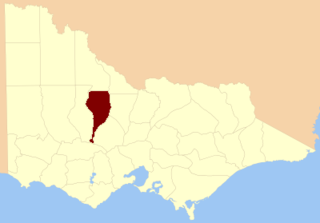
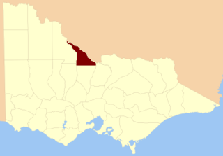
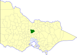
The Shire of Huntly was a local government area immediately to the northeast of the regional city of Bendigo, Victoria, Australia. The shire covered an area of 878 square kilometres (339.0 sq mi), and existed from 1866 until 1994. The shire had its origins in the creation of the Camapaspe Road District in 1861. The road district was renamed and redesignated as Huntly shire in 1866.
The Shire of McIvor was a local government area about 110 kilometres (68 mi) north of Melbourne, the state capital of Victoria, Australia. The shire covered an area of 1,295 square kilometres (500.0 sq mi), and existed from 1863 until 1994.
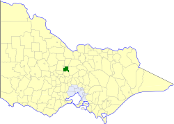
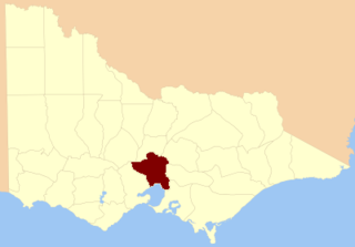
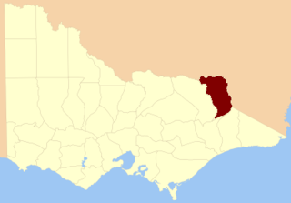
The Shire of Strathfieldsaye was a local government area immediately to the east and southeast of the regional city of Bendigo, Victoria, Australia, and included the eastern suburbs of Bendigo's metropolitan area. The shire covered an area of 601.34 square kilometres (232.2 sq mi), and existed from 1861 until 1994.
The City of Bendigo was a local government area covering the central area and inner western suburbs of the regional city of Bendigo, Victoria, Australia. The city covered an area of 32.53 square kilometres (12.6 sq mi) and existed from 1855 to 1994.
Weeroona College Bendigo is an Australian co-educational secondary school, catering for students in years 7 to 10, located in White Hills, a suburb of Bendigo, Victoria.
The electoral district of Bendigo was an electorate of the Victorian Legislative Assembly in the Australian state of Victoria. Centred on the city of Bendigo, the district was formed when the electorates of Bendigo East and Bendigo West were merged into a single district in 1927. Bendigo was abolished in 1985 when it was once again split into separate East and West districts.
Melbourne South Province was an electorate of the Victorian Legislative Council. It was created in June 1904 when Melbourne Province was reduced in size and North Yarra Province and South Yarra Province were abolished. The new Melbourne South, Melbourne North, Melbourne East and Melbourne West Provinces were then created.

The Electoral district of Grant was one of the sixteen electoral districts of the original unicameral Victorian Legislative Council (Australia) of 1851 to 1856.

Mandurang, derived from an Aboriginal word meaning black cicada, is a rural locality in the City of Greater Bendigo, in the Australian state of Victoria. It grew and developed as a goldfield settlement and logging locality, though today mostly consists of small farms and wineries. Mandurang Primary School was opened in 1877 and closed in 1994.
