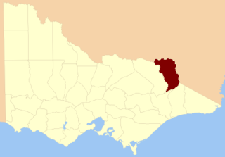
The Rural City of Wangaratta is a local government area in the Hume region of Victoria, Australia, located in the north-east part of the state. It covers an area of 3,639 square kilometres (1,405 sq mi) and, at the 2016 Census, had a population of 28,310. It includes the towns of Cheshunt, Eldorado, Everton, Glenrowan, Greta, Greta West, Milawa, Moyhu, Oxley, Tarrawingee, Wangaratta and Whitfield. It was formed in 1994 from the amalgamation of the City of Wangaratta, Shire of Wangaratta, Shire of Oxley, and parts of the United Shire of Beechworth, Shire of Benalla and Shire of Yarrawonga. When formed the municipality was originally called the Shire of Milawa, but a few months later, was renamed to its current name.
The Shire of Delatite was a local government area in Victoria, Australia, located in the north-east part of the state. It covered an area of 6,218 square kilometres (2,401 sq mi) and, at the 2001 census, had a population of 21,553. It included the towns of Benalla and Mansfield, and was formed in 1994 from the amalgamation of the City of Benalla, Shire of Benalla, the then Shire of Mansfield and part of the Shire of Violet Town. In 2002 the shire was split into the Rural City of Benalla and Shire of Mansfield. This process has been cited as an example of successful de-amalgamation by residents of other councils who are unhappy with the forced mergers that affected almost all Victorian local government areas in 1994.
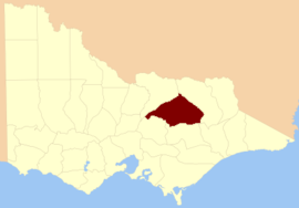
The Rural City of Benalla is a local government area in the Hume region of Victoria, Australia, located in the north-east part of the state. It covers an area of 3,843 square kilometres (1,484 sq mi) and, at the 2016 Census had a population of almost 14,000.

The Shire of Mansfield is a local government area in the Hume region of Victoria, Australia, located in the north-east part of the state. It covers an area of 3,843 square kilometres (1,484 sq mi) and at the 2016 Census, had a population of approximately 8,500.

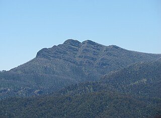
Mount Stirling is a mountain in the Victorian Alps of the Great Dividing Range, located in the Hume region of Victoria, Australia. The mountain has an elevation of 1,747–1,749 metres (5,732–5,738 ft) above sea level.
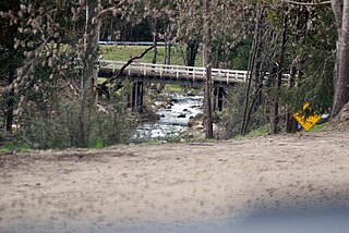
The Delatite River, an inland perennial river of the Goulburn Broken catchment, part of the Murray-Darling basin, is located in the lower South Eastern Highlands bioregion and Northern Country/North Central regions of the Australian state of Victoria. The headwaters of the Delatite River rise on the western slopes of the Victorian Alps and descend to flow into the Goulburn River within Lake Eildon.

The County of Bogong is one of the 37 counties of Victoria which are part of the cadastral divisions of Australia, used for land titles. It is located south of the Murray River, east of the Ovens River, and west of the Mitta Mitta River. Mount Bogong is located there, the highest mountain in Victoria. The county was proclaimed in 1871.

The King Valley, or King River Valley is a wine-producing and agricultural region centred on the King River between Wangaratta and the Alpine National Park in the North East Victoria zone of the Australian state of Victoria. There are a number of small towns within the region including Cheshunt, Whitfield, King Valley, Edi, Claremont, Moyhu, Byrne, Docker and Oxley. King Valley was recorded as an Australian Geographical Indication protected name on 12 October 2007.
South Townsville is a coastal suburb of the City of Townsville, Queensland, Australia. In the 2011 census, South Townsville had a population of 2,138 people.

The County of Dalhousie is one of the 37 counties of Victoria which are part of the cadastral divisions of Australia, used for land titles. It is located to the north of Melbourne. It is bounded by the Coliban River to the west. The Goulburn River forms part of the boundary to the north-east. Puckapunyal is on its northern edge, and Kilmore and Woodend on its southern edge. The county was proclaimed in 1849.

The County of Anglesey is one of the 37 counties of Victoria which are part of the cadastral divisions of Australia, used for land titles. It is located to the east of Seymour, on both sides of the Goulburn River. The county was proclaimed in 1849.

The County of Buln Buln is one of the 37 counties of Victoria which are part of the cadastral divisions of Australia, used for land titles. It was first proclaimed in government gazette on 24 Feb 1871 together with others from the Gipps Land District. It includes Wilsons Promontory, and the Victorian coast from around Venus Bay in the west to Lake Wellington in the east. Sale is near its north-eastern edge. Some time earlier maps showed proposed counties of Bass, Douro, and part of Haddington and Bruce occupying the area of Buln Buln.

The County of Tanjil is one of the 37 counties of Victoria which are part of the cadastral divisions of Australia, used for land titles. It includes the coastal area around the Gippsland Lakes. The Mitchell River is the north-eastern boundary. Before the 1860s, the area was part of the former county of Bruce and part of Haddington.
The County of Benambra is one of the 37 counties of Victoria which are part of the cadastral divisions of Australia, used for land titles. It is located between the Mitta Mitta River in the west, and the Murray River to the north and east. The town of Benambra is located near the southern edge. The area of the county roughly corresponds with the Electoral district of Benambra. Corryong is the largest town in the county. The county was proclaimed in 1871.
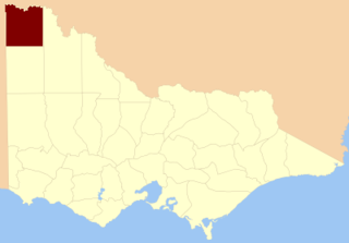
The County of Millewa is one of the 37 counties of Victoria which are part of the cadastral divisions of Australia, used for land titles. It is located to the south of the Murray River, at the north-western corner of Victoria, with the South Australian border to the west. This border was originally intended to be at the 141st meridian of longitude, but because of the South Australia-Victoria border dispute it is several miles to the west of it. The southern boundary of the county is at 35°S, and the eastern at 142°E. The name is also used for the region.

The Shire of Violet Town was a local government area about 170 kilometres (106 mi) northeast of Melbourne, the state capital of Victoria, Australia. The shire covered an area of 935 square kilometres (361.0 sq mi), and existed from 1895 until 1994.
The City of Benalla was a local government area about 188 kilometres (117 mi) northeast of Melbourne, the state capital of Victoria, Australia. The city, which was completely surrounded by the Shire of Benalla, covered an area of 17.76 square kilometres (6.9 sq mi), and existed from 1948 until 1994.

The Shire of Yackandandah was a local government area about 290 kilometres (180 mi) northeast of Melbourne, the state capital of Victoria, Australia. The shire covered an area of 1,148.75 square kilometres (443.5 sq mi), and existed from 1862 until 1994.
The Whitfield railway line was a 2 ft 6 in narrow gauge railway located in north-eastern Victoria, Australia, branching from the main North East railway at Wangaratta to the terminus of Whitfield.
Mount Cobbler is a mountain located in the Alpine National Park to the east of Mansfield in north-eastern Victoria, Australia. Its summit rises to 1,628 metres (5,341 ft) above sea level. The peak and surrounding Cobbler land system are composed of sedimentary rocks, dating to the Lower Carboniferous period, some 359 to 318 million years ago.