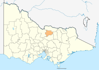
The City of Greater Shepparton is a local government area in the Hume region of Victoria, Australia, located in the north-east part of the state. It covers an area of 2,422 square kilometres (935 sq mi) and, at the 2016 Census, had a population of 63,867. It includes the city of Shepparton and the towns of Arcadia, Ardmona, Congupna, Dookie, Grahamvale, Kialla, Lemnos, Merrigum, Mooroopna, Murchison, Tallygaroopna, Tatura, Toolamba and Undera. It was formed in 1994 from the amalgamation of the City of Shepparton, Shire of Shepparton, and parts of the Shire of Rodney, Shire of Euroa, Shire of Goulburn, Shire of Tungamah, Shire of Violet Town and Shire of Waranga.

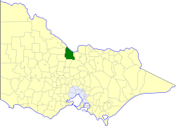
The Shire of Moira is a local government area in the Hume region of Victoria, Australia, located in the north-east part of the state. It covers an area of 4,045 square kilometres (1,562 sq mi) and at the 2016 Census had a population of over 29,000.

The Goulburn Valley is a sub-region, part of the Hume region of the Australian state of Victoria. The sub-region consists of those areas in the catchment of the Goulburn River and other nearby streams, and is part of the Murray-Darling Basin. The Goulburn Valley is bordered on the south by the Great Dividing Range and to the north by the Murray River, the state border with New South Wales. The sub-region is one of Australia's most productive and intensively farmed areas and is predominantly irrigated.

The electoral district of Shepparton is a rural Lower House electoral district of the Victorian Parliament. It is located within the Northern Victoria Region of the Legislative Council.

The Shire of Benalla was a local government area about 188 kilometres (117 mi) northeast of Melbourne, the state capital of Victoria, Australia. The shire covered an area of 2,322 square kilometres (896.5 sq mi), and existed from 1868 until 1994. From 1948 onwards, Benalla itself was managed by a different entity, later known as the City of Benalla.

The Shire of Deakin was a local government area in the Goulburn Valley region, about 200 kilometres (124 mi) north of Melbourne, the state capital of Victoria, Australia. The shire covered an area of 961 square kilometres (371.0 sq mi), and existed from 1893 until 1994.

The Shire of Euroa was a local government area about 145 kilometres (90 mi) northeast of Melbourne, the state capital of Victoria, Australia. The shire covered an area of 1,412 square kilometres (545.2 sq mi), and existed from 1879 until 1994.

The Shire of Nathalia was a local government area on the Murray River in the Goulburn Valley region about 220 kilometres (137 mi) north of Melbourne, the state capital of Victoria, Australia. The shire covered an area of 1,238.97 square kilometres (478.4 sq mi), and existed from 1879 until 1994.

The Shire of Numurkah was a local government area on the Murray River in the Goulburn Valley region about 210 kilometres (130 mi) north of Melbourne, the state capital of Victoria, Australia. The shire covered an area of 820 square kilometres (316.6 sq mi), and existed from 1957 until 1994.

The Shire of Rodney was a local government area in the Goulburn Valley region, about 170 kilometres (106 mi) north of Melbourne, the state capital of Victoria, Australia, located between Kyabram and Shepparton. The shire covered an area of 1,009.92 square kilometres (389.9 sq mi), and existed from 1886 until 1994.

The Shire of Shepparton was a local government area in the Goulburn Valley region, about 180 kilometres (112 mi) north of Melbourne, the state capital of Victoria, Australia. The shire covered an area of 927.49 square kilometres (358.1 sq mi), and existed from 1884 until 1994. From 1927 onwards, Shepparton itself was managed by a separate entity, ultimately known as the City of Shepparton.

The Shire of Tungamah was a local government area in the Goulburn Valley region about 240 kilometres (149 mi) northeast of Melbourne, the state capital of Victoria, Australia. The shire covered an area of 1,143 square kilometres (441.3 sq mi), and existed from 1878 until 1994.

The Shire of Yarrawonga was a local government area on the Murray River in the Goulburn Valley region about 260 kilometres (162 mi) northeast of Melbourne, the state capital of Victoria, Australia. The shire covered an area of 626.78 square kilometres (242.0 sq mi), and existed from 1891 until 1994.

The City of Shepparton was a local government area in the Goulburn Valley region, about 180 kilometres (112 mi) north of Melbourne, the state capital of Victoria, Australia. The city covered an area of 26.71 square kilometres (10.3 sq mi), and existed from 1927 until 1994. It excluded areas such as Mooroopna and Kialla, which are now considered to be suburbs.
The Shire of Rochester was a local government area of Victoria, Australia, about 190 kilometres (118 mi) north of Melbourne, the state capital, and immediately west and southwest of the town of Echuca. The shire covered an area of 1,934.25 square kilometres (746.8 sq mi), and existed from 1864 until 1994.
Goulburn Ovens Institute of TAFE, also known as GOTAFE, is a Technical and Further Education (TAFE) institute located in the north east region of Victoria, Australia based on the Goulburn and Ovens rivers, and is the largest regional TAFE in Victoria, and a specialist centre for food processing, equine and dairy education.
Yabba South is a locality in Victoria, Australia. The locality is in the southern part of the Shire of Moira. The former Katamatite Tramway ran through Yabba South.
Wangaratta and Rutherglen was an electoral district of the Legislative Assembly in the Australian state of Victoria from 1889 to 1904. It was located around the towns of Wangaratta and Rutherglen. When it was abolished in 1904, the new Electoral district of Wangaratta was created; John Bowser was the last member for Wangaratta and Rutherglen and the first for Wangaratta.

The Hume is an economic rural region located in the north-eastern part of Victoria, Australia. Comprising an area in excess of 40,000 square kilometres (15,000 sq mi) with a population that ranges from 263,000 to 300,000, the Hume region includes the local government areas of Alpine Shire, Rural City of Benalla, City of Wodonga, City of Greater Shepparton, Shire of Indigo, Shire of Mansfield, Shire of Strathbogie, Shire of Towong and the Rural City of Wangaratta, and also includes five unincorporated areas encompassing the alpine ski resorts in the region.
The Katamatite railway line is a disused railway located in northern Victoria, Australia. It was built as a tramway, running from Dookie to Katamatite, and opened on 11 August 1890. When it was taken over by the Victorian Railways (VR) in 1892 sections of the track were upgraded and it was reclassified as a railway. The line was formally closed on 13 January 1987.


