
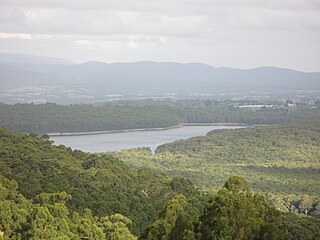
The Yarra Valley is the region surrounding the Yarra River in Victoria, Australia. The river originates approximately 240 kilometres east of the Melbourne central business district and flows towards it and out into Port Phillip Bay. The name Yarra Valley is used in reference to the upper regions surrounding the Yarra River and generally does not encompass the lower regions including the city and suburban areas, where the topography flattens out, or the upper reaches which are in inaccessible bushland. Included in the Yarra Valley is the sub-region of lower Yarra which encompasses the towns of the former Shire of lower Yarra in the catchment area upstream of and including Woori Yallock. The Yarra Valley is a popular day-trip and tourist area, featuring a range of natural features and agricultural produce, as well as the Lilydale to Warburton Rail Trail.

The Shire of Yarra Ranges, also known as Yarra Ranges Council, is a local government area in Victoria, Australia, located in the outer eastern and northeastern suburbs of Melbourne extending into the Yarra Valley and Dandenong Ranges. It has an area of 2,468 square kilometres (953 sq mi), of which 3% is classified as urban. In June 2018, it had a population of 158,173.

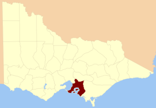
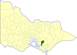
The Shire of Baw Baw is a local government area in Victoria, Australia, in the eastern part of the state. It covers an area of 4,028 square kilometres (1,555 sq mi) and in June 2018 had a population of 52,015.
Don Valley is a town in Victoria, Australia, approximately 70 km east of Melbourne's central business district. Its local government area is the Shire of Yarra Ranges. At the 2016 census, Don Valley had a population of 576.
Silvan is a town in Victoria, Australia, located 40 km east of Melbourne. Its local government area is the Shire of Yarra Ranges, and the town marks halfway between the Belgrave and Lilydale, both large towns. At the 2016 Census, Silvan had a population of 1246. The area's soils, well suited to growing fruits, vegetables and flowers, draw tourists to the various pick-yourself orchards and berry farms in Silvan. A cultivated hybrid variety of blackberry known as the silvanberry is named after the town.

Tarrawarra was a station on the former Healesville line between Yarra Glen and Healesville stations, in Victoria, Australia. The station opened in 1889 and closed along with the line in December 1980. In the 1970s, timetables showed that the station was a flag stop because of the small number of passengers using the station.
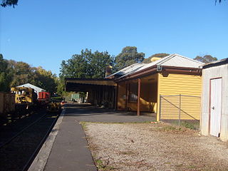
Healesville is a railway station in Victoria, Australia. Formerly the terminus of the Healesville railway line, it is currently the principal station of the Yarra Valley Railway.

The Division of Casey is an Australian electoral division in the state of Victoria. The division was created in 1969 and is named for Richard Casey, who was Governor-General of Australia 1965–69.
The Lilydale to Warburton Rail Trail is a walking, cycling and horse-riding track in eastern Victoria, Australia. It runs a distance of 38 km between Lilydale and Warburton, along the former Warburton railway line. A section between Corduroy Road in Yarra Junction and Warburton is also known as the Centenary Trail.

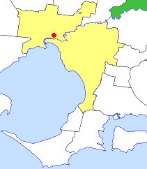
Tarrawarra is a locality in Victoria, Australia, 45 km north-east of Melbourne's central business district. Its local government area is the Shire of Yarra Ranges.
Yarra Valley FM is the local community radio station broadcasting to the Yarra Valley area of Victoria, Australia. It can be heard throughout the Shires of Yarra Ranges, Cardinia and Murrindindi, as well as many eastern Melbourne metropolitan municipalities.

The County of Anglesey is one of the 37 counties of Victoria which are part of the cadastral divisions of Australia, used for land titles. It is located to the east of Seymour, on both sides of the Goulburn River. The county was proclaimed in 1849.
The County of Mornington is one of the 37 counties of Victoria which are part of the cadastral divisions of Australia, used for land titles. It is located to the south-east of Melbourne, including the Mornington Peninsula, French Island and Phillip Island. The county was proclaimed in 1849.

The County of Buln Buln is one of the 37 counties of Victoria which are part of the cadastral divisions of Australia, used for land titles. It was first proclaimed in government gazette on 24 Feb 1871 together with others from the Gipps Land District. It includes Wilsons Promontory, and the Victorian coast from around Venus Bay in the west to Lake Wellington in the east. Sale is near its north-eastern edge. Some time earlier maps showed proposed counties of Bass, Douro, and part of Haddington and Bruce occupying the area of Buln Buln.

The Shire of Upper Yarra was a local government area centred on the upper reaches of the Yarra Valley, about 60 kilometres (37 mi) east of Melbourne, the state capital of Victoria, Australia, extending eastwards into Victoria's interior. The shire covered an area of 1,732 square kilometres (668.7 sq mi), and existed from 1888 until 1994.
The Shire of Healesville was a local government area about 60 kilometres (37 mi) northeast of Melbourne, the state capital of Victoria, Australia. The shire covered an area of 466.20 square kilometres (180.0 sq mi), and existed from 1887 until 1994.
The Shire of Buln Buln was a local government area about 95 kilometres (59 mi) east-southeast of Melbourne, the state capital of Victoria, Australia. The shire covered an area of 1,259 square kilometres (486.1 sq mi) and existed from 1878 until 1994.
Mount Toolebewong is a bounded rural locality in Victoria, Australia 65 kilometres north-east of Melbourne, Australia and south of Healesville. The summit of the mountain is 750m above sea level. Its local government area is the Shire of Yarra Ranges. At the 2016 Census, Mount Toolebewong had a population of 140.
Woori Yallock Creek is a tributary of the Yarra River. It rises on the eastern slopes of the Dandenong Ranges, then flows north to join the Yarra River near Woori Yallock.
Gippsland Province was an electorate of the Victorian Legislative Council from November 1882 until 2006. It was based in the Gippsland region of Victoria, Australia.
