Murray County was one of the original Nineteen Counties in New South Wales and is now one of the 141 Lands administrative divisions of New South Wales. It included the area which is now part of Canberra and as far north as Lake George and Yass. It was originally bounded on the west by the Murrumbidgee River, on the east by the Shoalhaven River and on the north by the Yass River. A large area of the county was transferred to the Commonwealth government in 1909 in the Seat of Government Acceptance Act to make part of the Australian Capital Territory, along with land in Cowley County. Since then, the ACT border is now part of the western boundary. Part of the ACT border is determined by property boundaries in the Parish of Keewong, in the County of Murray; specifically the southern end of portions 177, 218, 211, 36, and 38. This is mentioned in the Seat of Government Acceptance Act of 1909.
The County of Bourke is one of the 37 counties of Victoria which are part of the Lands administrative divisions of Australia, used for land titles. It is the oldest and most populous county in Victoria and contains the city of Melbourne. Like other counties in Victoria, it is subdivided into parishes. The county was named after General Sir Richard Bourke, the Governor of New South Wales between 1831 and 1837. It is bordered by the Werribee River in the west, the Great Dividing Range in the north, Port Phillip in the south, and by Dandenong Creek, a small part of the Yarra River, and the Plenty River in the east. The county was proclaimed in 1853.

The County of Grant is one of the 37 counties of Victoria which are part of the cadastral divisions of Australia, used for land titles. It is located to the west of Melbourne, on the west side of Port Phillip and includes Geelong. Ballarat is on its north-western edge. It is bounded in the west by the Yarrowee River, on the north by the Great Dividing Range and on the east by the Werribee River. The county was proclaimed in 1853.

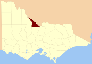
The County of Bendigo is one of the 37 counties of Victoria which are part of the cadastral divisions of Australia, used for land titles. It includes the city of Bendigo. It is bounded by the Campaspe River in the east, and the Loddon River in the west. The county was proclaimed in 1869.

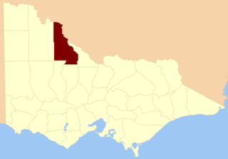
The County of Dalhousie is one of the 37 counties of Victoria which are part of the cadastral divisions of Australia, used for land titles. It is located to the north of Melbourne. It is bounded by the Coliban River to the west. The Goulburn River forms part of the boundary to the north-east. Puckapunyal is on its northern edge, and Kilmore and Woodend on its southern edge. The county was proclaimed in 1849.

The County of Buln Buln is one of the 37 counties of Victoria which are part of the cadastral divisions of Australia, used for land titles. It was first proclaimed in government gazette on 24 Feb 1871 together with others from the Gipps Land District. It includes Wilsons Promontory, and the Victorian coast from around Venus Bay in the west to Lake Wellington in the east. Sale is near its north-eastern edge. Some time earlier maps showed proposed counties of Bass, Douro, and part of Haddington and Bruce occupying the area of Buln Buln.

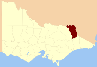
The County of Tanjil is one of the 37 counties of Victoria which are part of the cadastral divisions of Australia, used for land titles. It includes the coastal area around the Gippsland Lakes. The Mitchell River is the north-eastern boundary. Before the 1860s, the area was part of the former county of Bruce and part of Haddington.
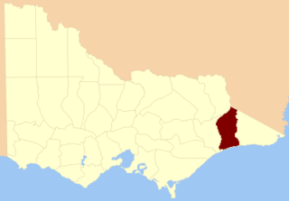
The County of Tambo is one of the 37 counties of Victoria which are part of the cadastral divisions of Australia, used for land titles. It is located in eastern Gippsland, between the Tambo River in the west, and the Snowy River in the east. It includes Lakes Entrance. Some time earlier maps showed proposed counties of Abinger and Combermere occupying the area.
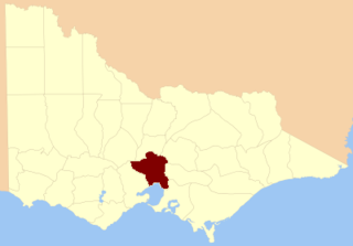
The County of Benambra is one of the 37 counties of Victoria which are part of the cadastral divisions of Australia, used for land titles. It is located between the Mitta Mitta River in the west, and the Murray River to the north and east. The town of Benambra is located near the southern edge. The area of the county roughly corresponds with the Electoral district of Benambra. Corryong is the largest town in the county. The county was proclaimed in 1871.
The County of Gunbower is one of the 37 counties of Victoria which are part of the cadastral divisions of Australia, used for land titles. It is located to the south of the Murray River, from Swan Hill to Echuca.
The County of Tatchera is one of the 37 counties of Victoria which are part of the cadastral divisions of Australia, used for land titles. It is located to the south of the Murray River, and to the south west of Swan Hill, with its western boundary at 143°E, and part of the southern boundary at 36°S.

The Shire of Karkarooc was a local government area in northwestern Victoria, Australia. The shire covered an area of 3,719 square kilometres (1,435.9 sq mi), and existed from 1896 until 1995.

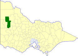
The Shire of Warracknabeal was a local government area about 200 kilometres (124 mi) west-northwest of Bendigo and 60 kilometres (37 mi) north of Horsham in western Victoria, Australia. The shire covered an area of 1,839 square kilometres (710.0 sq mi), and existed from 1891 until 1995.

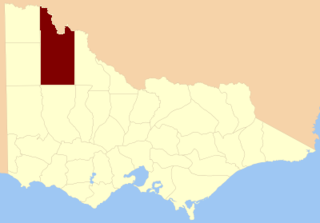
The County of Weeah is one of the 37 counties of Victoria which are part of the cadastral divisions of Australia, used for land titles. It is located south of Mildura, with the South Australian border to the west. This border was originally intended to be at the 141st meridian of longitude, but because of the South Australia-Victoria border dispute it is several miles to the west of it. The northern boundary of the county is at 35°S, and the eastern at 142°E. Its southern boundary is on the 36°S meridian. The County was proclaimed in 1871 together with the other counties of the Wimmera Land District.
The Shire of Dimboola was a local government area in the Wimmera region of western Victoria, Australia. The shire covered an area of 4,856 square kilometres (1,874.9 sq mi), and existed from 1885 until 1995.
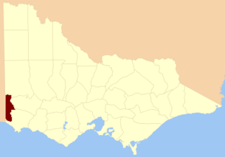
The County of Follett is one of the 37 counties of Victoria which are part of the cadastral divisions of Australia, used for land titles. It comprises a strip in the far southwest of the state bounded by the Glenelg River to the east, South Australia to the west and Elderslie Creek to the north beyond Casterton. No larger towns are contained within its boundaries. The county was proclaimed in 1849.

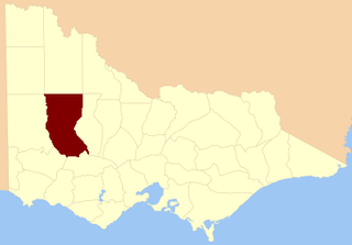
The County of Lowan is one of the 37 counties of Victoria which are part of the cadastral divisions of Australia, used for land titles. The northern boundary of the county is at 36°S. Larger towns include Dimboola, Edenhope and Kaniva. The county was proclaimed in 1871 together with the other counties of the Wimmera Land District.
The electoral district of Borung was an electorate of the Victorian Legislative Assembly in the Australian colony of Victoria, which existed in two incarnations, from 1889 to 1927, and then from 1945 to 1955.

MacCabe Corner is the name given to the south-west corner of the state of New South Wales, Australia. It is located 82 kilometres (51 mi) west of the town of Wentworth, New South Wales, on a bend of the Murray River. MacCabe Corner is named for Francis MacCabe, a surveyor who did considerable work exploring and mapping New South Wales, in particular the rivers of the Murray-Darling basin.