HM Prison Langi Kal Kal is an Australian prison located in Trawalla, near Beaufort, Victoria, Australia. The prison is a minimum security prison farm and all inmates are required to work if they are physical able and under 65. It is a minimum security pathway for protection prisoners from Hopkins Correctional Centre.

The County of Grant is one of the 37 counties of Victoria which are part of the cadastral divisions of Australia, used for land titles. It is located to the west of Melbourne, on the west side of Port Phillip, and includes Geelong. Ballarat is on its north-western edge. It is bounded in the west by the Yarrowee River, on the north by the Great Dividing Range and on the east by the Werribee River. The county was proclaimed in 1853.

Ripon is a single member electoral district of the Victorian Legislative Assembly. It is a rural electorate based in western Victoria. In 1946 the electoral district of Ripon was first contested but then abolished in the 1955 election after being held by Labor for seven of these years. Ripon was re-created in 1976, essentially as a replacement for Hampden and Kara Kara.
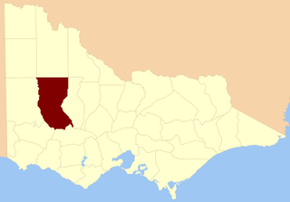
The Shire of Lexton was a local government area about 150 kilometres (93 mi) northwest of Melbourne, the state capital of Victoria, Australia. The shire covered an area of 821.03 square kilometres (317.0 sq mi), and existed from 1860 until 1994.

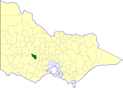
The Shire of Ripon was a local government area about 160 kilometres (99 mi) west-northwest of Melbourne, the state capital of Victoria, Australia. The shire covered an area of 1,533 square kilometres (591.9 sq mi), and existed from 1861 until 1994.

The County of Lowan is one of the 37 counties of Victoria which are part of the cadastral divisions of Australia, used for land titles. The northern boundary of the county is at 36°S. Larger towns include Dimboola, Edenhope and Kaniva. The county was proclaimed in 1871 together with the other counties of the Wimmera Land District.
The County of Borung is one of the 37 counties of Victoria which are part of the cadastral divisions of Australia, used for land titles. The northern boundary of the county is at 36°S. At the north its western boundary is 142°E, its eastern boundary is 143°E. Larger urban centres include Dimboola, Warracknabeal, Horsham and Stawell. The county was proclaimed in 1871 together with the other counties of the Wimmera Land District.

The County of Kara Kara is one of the 37 counties of Victoria which are part of the cadastral divisions of Australia, used for land titles. The northern boundary of the county is at 36°S. At the north its western boundary is 143°E. Larger towns include St Arnaud and Donald. The County was proclaimed in 1871 together with the other counties of the Wimmera Land District.
The County of Hampden is one of the 37 counties of Victoria which are part of the cadastral divisions of Australia, used for land titles. The county is in the Western District of Victoria bounded by Lake Corangamite in the east and the Hopkins River in the west. In the north and south the county was bounded approximately by the existing roads, now the Glenelg Highway and the Princes Highway. Larger towns include Terang and Skipton. The county was proclaimed in 1849.
The County of Heytesbury is one of the 37 counties of Victoria which are part of the cadastral divisions of Australia, used for land titles. The county is in the Western District of Victoria bounded by the Gellibrand River in the east and the Hopkins River in the west. In the north, the county was bounded approximately by the existing road, now the Princes Highway. Larger towns include Camperdown and Cobden. The county was proclaimed in 1849.

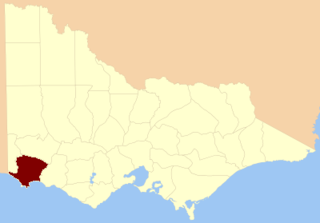
The County of Dundas is one of the 37 counties of Victoria which are part of the cadastral divisions of Australia, used for land titles. The county is in the Western District of Victoria bounded by the Glenelg River in the west and north, by a line from Casterton to Penshurst in the south, and by the eastern edge of the Grampians in the east. Larger towns include Hamilton, Casterton and Coleraine. The county was proclaimed in 1849.

The County of Polwarth is one of the 37 counties of Victoria which are part of the cadastral divisions of Australia, used for land titles. The county is in the Western District of Victoria and includes the Cape Otway area, bounded by the Gellibrand River in the west and the Anglesea River and Barwon River in the east, in the north by a line from Winchelsea, through Colac to Larpent, and by Bass Strait to the south. The largest town is Colac. The county was proclaimed in 1849.
The Electoral district of Normanby was an electoral district in the Legislative Assembly of Victoria, it covered an area from the South Australian border to Portland Bay.
Nelson Province was an electorate of the Victorian Legislative Council (Australia). It was created in the wide-scale redistribution of Provinces 1882 when Central and Eastern Provinces were abolished and ten new Provinces were created. Its area included Camperdown, Ararat and Mortlake.
The electoral district of Borung was an electorate of the Victorian Legislative Assembly in the Australian colony of Victoria, which existed in two incarnations, from 1889 to 1927, and then from 1945 to 1955.

Polwarth, Ripon, Hampden and South Grenville was an electoral district of the Legislative Assembly in the Australian state of Victoria from 1856 to 1859. It was based in western Victoria.

Grenville was an electoral district of the Legislative Assembly in the Australian state of Victoria from 1859 to 1927. It was located in western Victoria, south of Ballarat.
Kara Kara was an electoral district of the Legislative Assembly in the Australian state of Victoria from 1877 to 1927 and 1955 to 1976. It was based in north-western Victoria and included the subdivisions of Donald, Charlton, Minyip, Murtoa, St. Arnaud, Wedderburn, Inglewood, Dunnolly, Landsborough, Avoca, Maryborough and Carisbrook. It was abolished in 1976 and replaced by the electoral district of Ripon.

Polwarth and South Grenville was an electoral district of the Legislative Assembly in the Australian state of Victoria from 1859 to 1889. It was based in western Victoria.

Ripon and Hampden was an electoral district of the Legislative Assembly in the Australian state of Victoria from 1859 to 1904. It was based in western Victoria.
