
Lands administrative divisions of Australia are the cadastral divisions of Australia for the purposes of identification of land to ensure security of land ownership. Most states term these divisions as counties, parishes, hundreds, and other terms. The eastern states of Queensland, New South Wales, Victoria and Tasmania were divided into counties and parishes in the 19th century, although the Tasmanian counties were renamed land districts in the 20th century. Parts of South Australia (south-east) and Western Australia (south-west) were similarly divided into counties, and there were also five counties in a small part of the Northern Territory. However South Australia has subdivisions of hundreds instead of parishes, along with the Northern Territory, which was part of South Australia when the hundreds were proclaimed. There were also formerly hundreds in Tasmania. There have been at least 600 counties, 544 hundreds and at least 15,692 parishes in Australia, but there are none of these units for most of the sparsely inhabited central and western parts of the country.

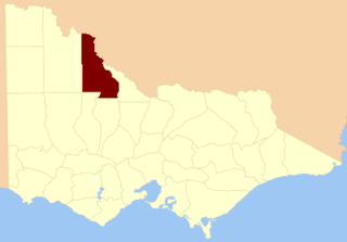
The County of Delatite is one of the 37 counties of Victoria which are part of the cadastral divisions of Australia, used for land titles. It is located south west of Ovens River. Wangaratta is partly located in the county, at the northern end.

The County of Moira is one of the 37 counties of Victoria which are part of the cadastral divisions of Australia, used for land titles. It is located to the east of the Goulburn River, south of the Murray River, and west of part of the Ovens River. Part of Wangaratta is in the county, on the eastern end of it. It also includes Shepparton. The Shire of Moira is in a similar area.

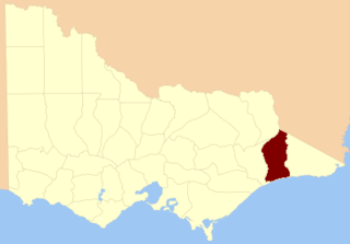
The County of Evelyn is one of the 37 counties of Victoria which are part of the cadastral divisions of Australia, used for land titles. It is located to the east of Melbourne, on both sides of the upper reaches of the Yarra River in the Yarra Valley. The Great Dividing Range is the boundary to the north. The county was proclaimed in 1849.
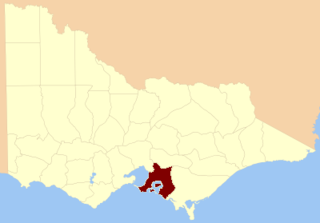
The County of Mornington is one of the 37 counties of Victoria which are part of the cadastral divisions of Australia, used for land titles. It is located to the south-east of Melbourne, including the Mornington Peninsula, French Island and Phillip Island. The county was proclaimed in 1849.

The County of Dargo is one of the 37 counties of Victoria which are part of the cadastral divisions of Australia, used for land titles. It is located in Gippsland, between the Mitchell River in the west and the Tambo River in the east. Lake King is on the southern edge. It was gazetted in 1871. Earlier maps show the area as being part of a proposed County of Abinger.
The County of Tambo is one of the 37 counties of Victoria which are part of the cadastral divisions of Australia, used for land titles. It is located in eastern Gippsland, between the Tambo River in the west, and the Snowy River in the east. It includes Lakes Entrance. Some time earlier maps showed proposed counties of Abinger and Combermere occupying the area.

The County of Croajingolong is one of the 37 counties of Victoria which are part of the cadastral divisions of Australia, used for land titles. It is the most easterly county, and includes the Croajingolong National Park. Its western boundary is the Snowy River. The county was proclaimed in 1871 together with others from the Gipps Land District. Some time earlier maps showed proposed counties of Howe and Combermere occupying the area of Croajingolong.

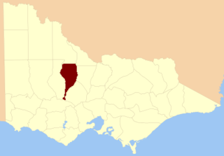
The County of Wonnangatta is one of the 37 counties of Victoria which are part of the cadastral divisions of Australia, used for land titles. It includes the western parts of the Alpine National Park. The Wonnangatta River is located in the east of the county. Lake Eildon is at the northwestern edge. Mount Buller is on the northern edge.

The County of Rodney is one of the 37 counties of Victoria which are part of the cadastral divisions of Australia, used for land titles. It is located between the Goulburn River in the east, and the Campaspe River in the west, with a small part of the Murray River to the north. Puckapunyal is near its southern edge. The former electoral district of Rodney was in a similar area.
The County of Gladstone is one of the 37 counties of Victoria which are part of the cadastral divisions of Australia, used for land titles. It is located between the Avoca River in the west and Loddon River and Bet Bet Creek in the east. The county was proclaimed in 1870.
The County of Tatchera is one of the 37 counties of Victoria which are part of the cadastral divisions of Australia, used for land titles. It is located to the south of the Murray River, and to the south west of Swan Hill, with its western boundary at 143°E, and part of the southern boundary at 36°S.
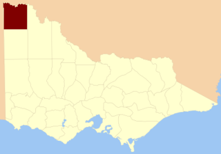
The County of Millewa is one of the 37 counties of Victoria which are part of the cadastral divisions of Australia, used for land titles. It is located to the south of the Murray River, at the north-western corner of Victoria, with the South Australian border to the west. This border was originally intended to be at the 141st meridian of longitude, but because of the South Australia-Victoria border dispute it is several miles to the west of it. The southern boundary of the county is at 35°S, and the eastern at 142°E. The name is also used for the region.
The Shire of Yea was a local government area about 110 kilometres (68 mi) northeast of Melbourne, the state capital of Victoria, Australia. The shire covered an area of 1,392.32 square kilometres (537.6 sq mi), and existed from 1869 until 1994. The shire's population was dominated by the town of Yea.

The Shire of Benalla was a local government area about 188 kilometres (117 mi) northeast of Melbourne, the state capital of Victoria, Australia. The shire covered an area of 2,322 square kilometres (896.5 sq mi), and existed from 1868 until 1994. From 1948 onwards, Benalla itself was managed by a different entity, later known as the City of Benalla.

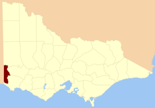
The County of Weeah is one of the 37 counties of Victoria which are part of the cadastral divisions of Australia, used for land titles. It is located south of Mildura, with the South Australian border to the west. This border was originally intended to be at the 141st meridian of longitude, but because of the South Australia-Victoria border dispute it is several miles to the west of it. The northern boundary of the county is at 35°S, and the eastern at 142°E. Its southern boundary is on the 36°S meridian. The County was proclaimed in 1871 together with the other counties of the Wimmera Land District.
The County of Follett is one of the 37 counties of Victoria which are part of the cadastral divisions of Australia, used for land titles. It comprises a strip in the far southwest of the state bounded by the Glenelg River to the east, South Australia to the west and Elderslie Creek to the north beyond Casterton. No larger towns are contained within its boundaries. The county was proclaimed in 1849.

The County of Polwarth is one of the 37 counties of Victoria which are part of the cadastral divisions of Australia, used for land titles. The county is in the Western District of Victoria and includes the Cape Otway area, bounded by the Gellibrand River in the west and the Anglesea River and Barwon River in the east, in the north by a line from Winchelsea, through Colac to Larpent, and by Bass Strait to the south. The largest town is Colac. The county was proclaimed in 1849.

The electoral district of Anglesey was an electoral district of the Legislative Assembly in the Australian state of Victoria.
Dalhousie was an electoral district of the Legislative Assembly in the Australian state of Victoria from 1859 to 1927. It was based in north-western Victoria. The district had been named Electoral district of Anglesey. The district of Dalhousie was defined in the 1858 Electoral Act as :


