Murrindindi, Victoria

Last updated

Murrindindi
Victoria
Murrindindi.jpg
The Murrindindi River flows through the town
Australia Victoria Murrindindi Shire location map.svg
Red pog.svg
Murrindindi
Coordinates 37°23′25″S145°34′40″E / 37.39028°S 145.57778°E / -37.39028; 145.57778 Coordinates: 37°23′25″S145°34′40″E / 37.39028°S 145.57778°E / -37.39028; 145.57778
Population107 (2016 census) [1]
Postcode(s) 3717
Location
LGA(s) Shire of Murrindindi
State electorate(s) Eildon
Federal division(s) Indi

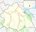
Murrindindi is a locality along the valley of the Murrindindi River in Victoria, in eastern Australia in the Murrindindi local government area. The nearest town is Yea. At the 2016 census, the suburb of Murrindindi had a population of 107. [1]

Contents

Location and history

The name comes from the pastoral run begun by squatter Peter Snodgrass in 1837, which was originally (and probably correctly) spelled Murrundindi. In the Woiwurrung language of central Victoria the name means "living in the mountains". However, the inaccurate translation "mist of the mountains" is sometimes given. [2] [3]

Snodgrass's station covered the area from the present-day town of Yea up the valleys of the east and west branches of the Muddy Creek, now the Yea River. His homestead was near the junction of these two branches, therefore surveyors named the east branch Murrindindi Creek, now the Murrindindi River. [2]

There has never been a Murrindindi town. The gold rush town of Higinbotham (began 1868, lasted for a few years, now completely vanished) with a maximum of 200 residents was the nearest to a town that the valley has seen. [4] Modern maps place the name Murrindindi at the site where the War Memorial Hall once stood (now a public reserve) or a little further to the south on Cummins Lane where the local volunteer fire station is situated. In the late 19th and early 20th centuries these would have been called Lower Murrindindi, and Upper Murrindindi was the locality now called Woodbourne and adjacent areas up the Ault Beag Creek. Ault Beag (Gaelic for "little creek") was named by an early Scots settler, Duncan McLeish. [4]

Farming and timber were the main industries of the area when the British settled the valley, and remain so today. Although much of the area was deforested by the timber industry, regrowth and sustainable logging techniques have restored the forests to some semblance of their former beauty, with management today as the Black Range State Forest. Tourism (trail-bike riding, fishing etc.) and sightseeing (rapids on the Murrindindi River, and the Wilhelmina Falls on a tributary) activities are carried on in the forest areas.

Recent developments

Since the 1990s there has been a considerable growth in the number of vineyards in the valley, which is in the Upper Goulburn wine region of Victoria. These grow cabernet sauvignon, merlot, pinot noir and chardonnay grapes, primarily for wineries outside the area (and the grapes are usually labelled "Yea Valley"), but Cuthbertson's Murrindindi and Sedona are two local vineyard/winery labels.

On 7 February 2009 a fire started at the old abandoned Murrindindi timber mill which spread to become one of the major conflagrations known as Black Saturday.[ citation needed ] Although there were no human casualties at Murrindindi, many people died further away at Marysville and Narbethong.[ citation needed ]

Related Research Articles

<span class="mw-page-title-main">Shire of Murrindindi</span> Local government area in Victoria, Australia

The Shire of Murrindindi is a local government area in the Hume region of Victoria, Australia, located in the north-east part of the state. It covers an area of 3,880 square kilometres (1,500 sq mi) and, in June 2018, had a population of 14,478. It includes the towns of Alexandra, Buxton, Eildon, Flowerdale, Kinglake, Marysville, Molesworth, Strath Creek, Taggerty, Yarck and Yea. It was formed in 1994 from the amalgamation of the Shire of Alexandra, Shire of Yea, and parts of the Shire of Broadford, Shire of Eltham, Shire of Euroa, Shire of Healesville and City of Whittlesea.

<span class="mw-page-title-main">Seymour, Victoria</span> Town in Victoria, Australia

Seymour is a historic railway township located in the Southern end of the Goulburn Valley in the Shire of Mitchell, Victoria, Australia and is located 104 kilometres (65 mi) north of Melbourne. At the 2021 census, Seymour had a population of 6,569. The township services the surrounding agricultural industries as well as the nearby military base of Puckapunyal, which is an important training centre for the Australian Army. Other important sectors of employment in Seymour include retail, light engineering, agricultural services support, medical services, and education.

<span class="mw-page-title-main">Yea, Victoria</span> Town in Victoria, Australia

Yea is a town in Victoria, Australia 100 kilometres (62 mi) north-east of the state capital Melbourne at the junction of the Goulburn Valley Highway and the Melba Highway, in the Shire of Murrindindi local government area. In an area originally inhabited by the Taungurung people, it was first visited by Europeans of the Hume and Hovell expedition in 1824, and within 15 years most of the land in the area had been taken up by graziers. Surveyed in 1855, the township grew as a service centre for grazing, gold-mining and timber-getting in the area.

<span class="mw-page-title-main">Alexandra, Victoria</span> Town in Victoria, Australia

Alexandra is a town in north-east Victoria, Australia, 130 kilometres north-east of the State Capital, Melbourne. It is located at the junction of the Goulburn Valley Highway (B340) and Maroondah Highway (B360), in the Shire of Murrindindi local government area. At the 2016 census, the town had a population of 2,695 and the broader area a population of 6420.

<span class="mw-page-title-main">Yadkin Valley AVA</span>

The Yadkin Valley AVA is an American Viticultural Area that includes land in seven counties of northwestern North Carolina. The AVA encompasses an area of approximately 1,400,000 acres (5,666 km2) in the Yadkin River valley. The Yadkin Valley AVA includes all of Wilkes, Surry, and Yadkin counties, and parts of Davie, Davidson, Forsyth, and Stokes counties. Yadkin Valley is home to 47 wineries.

<span class="mw-page-title-main">Goulburn Valley</span>

The Goulburn Valley is a sub-region, part of the Hume region of the Australian state of Victoria. The sub-region consists of those areas in the catchment of the Goulburn River and other nearby streams, and is part of the Murray-Darling Basin. The Goulburn Valley is bordered on the south by the Great Dividing Range and to the north by the Murray River, the state border with New South Wales. The sub-region is one of Australia's most productive and intensively farmed areas and is predominantly irrigated.

Langhorne Creek is a town in South Australia. At the 2016 census, Langhorne Creek had a population of 427.

<span class="mw-page-title-main">Cheviot, Victoria</span> Town in Victoria, Australia

Cheviot is a locality in Victoria, Australia in the Shire of Murrindindi local government area.

<span class="mw-page-title-main">Pyrenees (Victoria)</span> Wine region in Victoria, Australia

The Pyrenees is a wine-producing region centred on the Pyrenees ranges located in Victoria, Australia near the town of Avoca.

<span class="mw-page-title-main">Rogue Valley AVA</span>

The Rogue Valley AVA is an American Viticultural Area located in southern Oregon. The federal government approved this appellation in 1991. It is entirely contained within the larger Southern Oregon AVA and includes the drainage basin of the Rogue River and several tributaries, including the Illinois River, the Applegate River, and Bear Creek. Most wineries in the region are found in the valleys formed by one of these three tributaries, rather than along the Rogue River itself. The region is 70 miles (113 km) wide by 60 miles (97 km) long ; there are fewer than 20 wineries with only 1,100 acres (450 ha) planted. Each river valley has a unique terroir, and grows different varieties of grapes. Overall, however, this region is the warmest and driest of Oregon's wine-growing regions.

<span class="mw-page-title-main">Yakima Valley AVA</span> Wine grape-growing region in Washington, U.S.

The Yakima Valley AVA was the first American Viticultural Area established within Washington state, gaining the recognition in 1983. Part of the larger Columbia Valley AVA, Yakima Valley AVA is home to more than 18,000 acres (73 km2) of vineyards, giving the area the largest concentration of wineries and vineyards in the state. The most widely planted varietals in the area are Chardonnay, Riesling, Merlot, Cabernet Sauvignon, Pinot gris, and Syrah. Nearly 40% of Washington state yearly wine production is made from Yakima Valley grapes. In addition to grapes, the Yakima Valley is also home to several fruit orchards growing apples, cherries, nectarines, peaches, pears and plums. Around the town of Zillah, there is the Zillah Fruit Loop driving tour through the area's orchards and vineyards. The area is also home to nearly 80% of the US hop production.

<span class="mw-page-title-main">Sonoma County wine</span>

Sonoma County wine is wine made in Sonoma County, California, in the United States.

<span class="mw-page-title-main">Spring Mountain District AVA</span> American Viticultural Area in California, United States

The Spring Mountain District AVA is an American Viticultural Area located in the Napa Valley AVA in California. Spring Mountain District AVA was officially established as an American Viticulture Area in 1993. Encompassed within its bounds are about 8,600 acres (3,480 ha), of which about 1,000 acres (400 ha) are planted to vineyards. Given the small crop yields on hillsides, the region represents less than 2% of Napa Valley wine. Currently the region has just over 30 winegrowers.

<span class="mw-page-title-main">South Australian wine</span>

The South Australian wine industry is responsible for more than half the production of all Australian wine. South Australia has a vast diversity in geography and climate which allows the state to be able to produce a range of grape varieties–from the cool climate Riesling variety in the Clare Valley wine region to the big, full bodied Shiraz wines of the Barossa Valley.

<span class="mw-page-title-main">Ohio wine</span>

Ohio wine refers to wine made from grapes grown in the U.S. state of Ohio. Historically, this has been wine grown from native American species of grapes, not European wine grapes, although hybrid and Vitis vinifera grapes are now common in Ohio. As of 2018 there were 280 commercial wineries operating in Ohio, and there are five designated American Viticultural Areas partially or completely located within the state.

<span class="mw-page-title-main">Shire of Yea</span> Local government area in Victoria, Australia

The Shire of Yea was a local government area about 110 kilometres (68 mi) northeast of Melbourne, the state capital of Victoria, Australia. The shire covered an area of 1,392.32 square kilometres (537.6 sq mi), and existed from 1869 until 1994. The shire's population was dominated by the town of Yea.

<span class="mw-page-title-main">Yea River</span> River in Victoria, Australia

The Yea River, an inland perennial river of the Goulburn Broken catchment, part of the Murray-Darling basin, is located in the lower South Eastern Highlands bioregion and Northern Country/North Central regions of the Australian state of Victoria.

<span class="mw-page-title-main">Murrindindi River</span> River in Victoria, Australia

The Murrindindi River, an inland perennial river of the Goulburn Broken catchment, part of the Murray-Darling basin, is located in the lower South Eastern Highlands bioregion and Northern Country/North Central regions of the Australian state of Victoria. The headwaters of the Murrindindi River rise on the western slopes of the Victorian Alps and descend to flow into the Yea River.

<span class="mw-page-title-main">Moonambel</span> Town in Victoria, Australia

Moonambel is a town in the Pyrenees region of the Australian state of Victoria, situated along the Stawell-Avoca Road [about 8 kilometres (5.0 mi) from the junction with the Sunraysia Highway]. The town is located in the Pyrenees Shire Local Government Area, near the heart of the Pyrenees wine region. The name 'Moonambel' is believed to be an aboriginal word meaning 'hollow in the hills'.

Rubicon is a locality in Victoria, Australia, located in the Shire of Murrindindi. It is situated on the Rubicon River. In the 2016 census, Rubicon had a population of 56.

References

  1. 1 2 "2016 Census QuickStats Murrindindi". Australian Bureau of Statistics. Retrieved 3 August 2019.
  2. 1 2 Blanks, Harvey. The Story of Yea. ISBN   0725-601-07-8.
  3. Sinnott, Nigel. Place-names of the Alexandra, Lake Eildon and Big River area of Victoria. Alexandra. ISBN   0957-809-80-8.
  4. 1 2 Sinnott, Nigel. "Higinbotham" (PDF) (PDF). Archived from the original (PDF) on 29 August 2008. Retrieved 26 November 2008.

Commons-logo.svg Media related to Murrindindi, Victoria at Wikimedia Commons