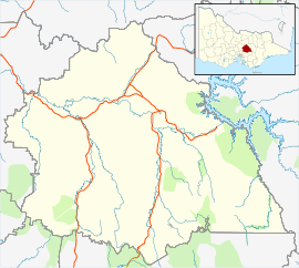
The Limestone Coast is a name used since the early twenty-first century for a South Australian government region located in the south east of South Australia which immediately adjoins the continental coastline and the Victorian border. The name is also used for a tourist region and a wine zone both located in the same part of South Australia.

The Northern Limestone Alps, also called the Northern Calcareous Alps, are the ranges of the Eastern Alps north of the Central Eastern Alps located in Austria and the adjacent Bavarian lands of southeastern Germany. The distinction from the latter group, where the higher peaks are located, is based on differences in geological composition.

The Central Eastern Alps, also referred to as Austrian Central Alps or just Central Alps comprise the main chain of the Eastern Alps in Austria and the adjacent regions of Switzerland, Liechtenstein, Italy and Slovenia. Below it are the Southern Limestone Alps.

The Ashford Caves, located within the Kwiambal National Park, are a series of caves that contain an outcrop of coralline limestone and are located in the New England Northern Tablelands region of New South Wales, in eastern Australia. The caves are managed by the NSW National Parks & Wildlife Service and are situated approximately 8 kilometres (5.0 mi) west of the former Ashford coal mine, north of Ashford and not far from the Queensland border town of Texas.

Prime Seal Island is a long island, with a high central ridge and an area of 1220 ha, in south-eastern Australia. It is part of Tasmania’s Prime Seal Island Group, lying in eastern Bass Strait west of Flinders in the Furneaux Group. Geologically, it is limestone overlying granite and has notable karst features, including caves. It is leased for farming and is extensively grazed by sheep and cattle as well as the native Tasmanian pademelons.

The East Kangaroo Island, part of the Big Green Group within the Furneaux Group, is a 157-hectare (390-acre) unpopulated limestone island with granite outcrops and dolerite dykes, located in the Bass Strait, west of the Flinders Island, in Tasmania, in south-eastern Australia.
The Big Green Island, part of the Big Green Group within the Furneaux Group, is a 122-hectare (300-acre) granite island with limestone and dolerite outcrops, located in Bass Strait west of Flinders Island, in Tasmania, in south-eastern Australia. The island is partly contained within a nature reserve with the rest being used for farming; and is part of the Chalky, Big Green and Badger Island Groups Important Bird Area.

The Chalky Island, part of the Big Green Group within the Furneaux Group, is a 41-hectare (100-acre) unpopulated granite island with limestone outcrops and dolerite dykes, located in the Bass Strait, west of the Flinders Island, in Tasmania, in south-eastern Australia. The island is contained within a conservation area and is part of the Chalky, Big Green and Badger Island Groups Important Bird Area.
The Nambung River is a river in the Wheatbelt region of Western Australia, 170 kilometres (106 mi) north of Perth. The river drains an area between the towns of Cervantes and Badgingarra. In its lower reaches the Nambung River forms a chain of waterholes in the Nambung Wetlands where it disappears underground into a limestone karst system 5.5 kilometres (3 mi) from the Indian Ocean.

Dudley Conservation Park is a protected area in South Australia on the Dudley Peninsula on Kangaroo Island. It was dedicated in 1970 to conserve Kangaroo Island Narrow-leaved Mallee.

Limestone Ridges is a locality in the Scenic Rim Region, Queensland, Australia. The Ipswich Boonah Road marks the eastern boundary of the locality.
Fossil Cave (5L81), formerly known as The Green Waterhole, is a cave in the Limestone Coast region of south-eastern South Australia. It is located in the gazetted locality of Tantanoola about 22 kilometres north-west of the city of Mount Gambier, only a few metres from the Princes Highway between Mount Gambier and Millicent. It is notable both as a paleontological site and as a cave diving site.

The Cliefden Caves ia heritage-listed geoheritage site in Mandurama, Cowra Shire, New South Wales, Australia. The caves comprises Ordovician fossil localities, limestone caves, a spring and tufa dams, and a site where limestone was first discovered in inland Australia.
In South Australia, one of the states of Australia, there are many areas which are commonly known by regional names. Regions are areas that share similar characteristics. These characteristics may be natural such as the Murray River, the coastline, desert or mountains. Alternatively, the characteristics may be cultural, such as common land use. South Australia is divided by numerous sets of regional boundaries, based on different characteristics. In many cases boundaries defined by different agencies are coterminous.
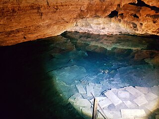
Engelbrecht Cave is a cave system in the Australian state of South Australia consisting of a sinkhole with two major passages located under the Mount Gambier urban area. It is owned by the local government area of City of Mount Gambier and has been developed as a tourism venue. Its dry extent is notable as a show cave while its water-filled extent is notable as two separate cave diving sites.

Big Heath Conservation Park is a protected area in the Australian state of South Australia located in the gazetted locality of Spence about 20 kilometres (12 mi) south-west of Naracoorte in the state's Limestone Coast region.
Bangham Conservation Park is a protected area in the Australian state of South Australia located in the state's Limestone Coast in the gazetted locality of Bangham about 45 kilometres (28 mi) north-east of the town centre in Naracoorte.
Mount Scott Conservation Park is a protected area in the Australian state of South Australia located in the gazetted locality of Blackford about 23 kilometres (14 mi) east of Kingston SE in the state's Limestone Coast region.
Telford Scrub Conservation Park is a protected area in the Australian state of South Australia located in the state's Limestone Coast in the gazetted locality of Dismal Swamp about 14 kilometres (8.7 mi) north of the city centre in Mount Gambier.
Mary Seymour Conservation Park is a protected area in the Australian state of South Australia located in the south-east of the state in the gazetted locality of Bool Lagoon about 25 kilometres (16 mi) south-west of the town centre of Naracoorte.