The Kinglake National Park is a national park in Central Victoria, Australia. The 23,210-hectare (57,400-acre) national park is situated 50 kilometres (31 mi) northeast of Melbourne and includes tracks, and camping facilities.

The Shire of Murrindindi is a local government area in the Hume region of Victoria, Australia, located in the north-east part of the state. It covers an area of 3,880 square kilometres (1,500 sq mi) and, in June 2018, had a population of 14,478. It includes the towns of Alexandra, Buxton, Eildon, Flowerdale, Kinglake, Marysville, Molesworth, Strath Creek, Taggerty, Yarck and Yea. It was formed in 1994 from the amalgamation of the Shire of Alexandra, Shire of Yea, and parts of the Shire of Broadford, Shire of Eltham, Shire of Euroa, Shire of Healesville and City of Whittlesea.

Francois Robert "Rob" de Castella is an Australian former world champion marathon runner.
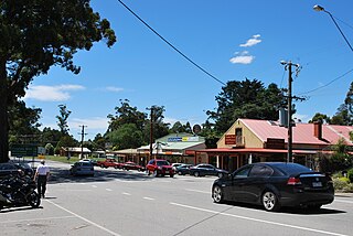
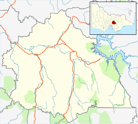
Kinglake is a town in Victoria, Australia, 56 km (35 mi) north-east of Melbourne's Central Business District, located within the Shires of Murrindindi and Nillumbik local government areas. Kinglake recorded a population of 1,662 at the 2021 census.

Mawson Lakes is a residential suburb in the City of Salisbury, Adelaide, Australia. Named in honor of Sir Douglas Mawson, it has a census area population of 10,872 people. The suburb is located in the northern suburbs of Adelaide around 12 km north of the Central business district. Much of the suburb was previously known as The Levels, and was a non-residential area, housing a campus of the University of South Australia and Technology Park Adelaide.
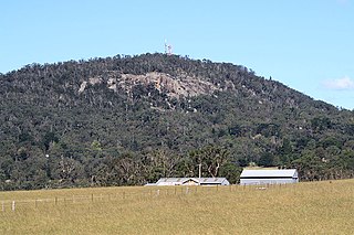
Mount Gibraltar is a mountain with an elevation of 863 metres (2,831 ft) AHD that is located in the Southern Highlands region, between Bowral and Mittagong, in New South Wales, Australia. Further west is Berrima.

The Airport Link is a tunnelled, motorway grade, toll road in the northern suburbs of Brisbane, Queensland, Australia. It connects the Brisbane central business district and the Clem Jones Tunnel to the East-West Arterial Road which leads to the Brisbane Airport. It was built in conjunction with the Windsor to Kedron section of the Northern Busway in approximately the same corridor.

Bombo is a suburb of the Municipality of Kiama, in the Illawarra region of New South Wales, Australia. It is located 2 kilometres (1.2 mi) north of Kiama.

Hemmant is a suburb of the City of Brisbane, Queensland, Australia. In the 2016 census, Hemmant had a population of 2,385 people.
Pipe ramming is a trenchless method for installation of steel pipes and casings. Distances of 30 m or more and over 500 mm in diameter are common, although the method can be used for much longer and larger installations. The method is useful for pipe and casing installations under railway lines and roads, where other trenchless methods could cause subsidence or heaving. The majority of installations are horizontal, although the method can be used for vertical installations.
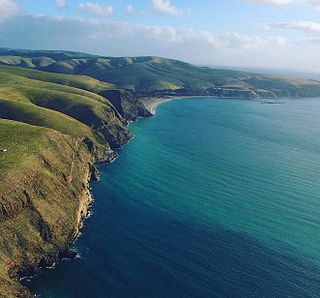
Rapid Bay is a locality that includes a small seaside town and bay on the west coast of the Fleurieu Peninsula, South Australia. It lies within the District Council of Yankalilla and its township is approximately 100 km south of the state capital, Adelaide. A pair of jetties are popular attractions for recreational fishing, scuba diving and snorkelling. The bay particularly known as a site for observing leafy seadragons in the wild. Its postcode is 5204.

The Shire of Eltham was a local government area about 25 kilometres (16 mi) northeast of Melbourne, the state capital of Victoria, Australia. The shire covered an area of 277.13 square kilometres (107.0 sq mi), and existed from 1856 until 1994.
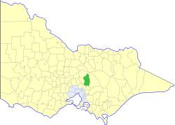
The Shire of Yea was a local government area about 110 kilometres (68 mi) northeast of Melbourne, the state capital of Victoria, Australia. The shire covered an area of 1,392.32 square kilometres (537.6 sq mi), and existed from 1869 until 1994. The shire's population was dominated by the town of Yea.

The M5 Legacy Way is a 4.6 kilometres (2.9 mi) long tunnel linking the Western Freeway at Toowong and the Inner City Bypass at Kelvin Grove, Brisbane. The project consisted of two bored tunnels carrying two motorway grade lanes of traffic in each direction. It opened on 25 June 2015 and is the fourth of five components of Brisbane City Council's TransApex Project. The tunnels will be tolled for approximately 45 years.

The Black Saturday bushfires were a series of bushfires that either ignited or were already burning across the Australian state of Victoria on and around Saturday, 7 February 2009, and were among Australia's all-time worst bushfire disasters. The fires occurred during extreme bushfire weather conditions and resulted in Australia's highest-ever loss of human life from a bushfire, with 173 fatalities. Many people were left homeless as a result.

Kilmore East is a locality in the Australian state of Victoria, 65 kilometres north of Melbourne. At the 2016 census, Kilmore East had a population of 417.
A series of major bushfires occurred between 26 January and 10 March 1926 in the state of Victoria in Australia. A total of 60 people were killed with 700 injured, and 1000 buildings and 390,000 ha were destroyed across the south-east of the state.

Ardglen is a village on the Main North railway line and close to the New England Highway on the North West Slopes region of New South Wales, Australia.

Harlin is a rural town and locality in the Somerset Region, Queensland, Australia. In the 2016 census, the locality of Harlin had a population of 173 people.

The Yarra Valley is an Australian wine region located east of Melbourne, Victoria. It is a cool climate region that is best known for producing Chardonnay, sparkling wine and Pinot Noir. Its proximity to the urban centre and high profile wineries have made it an important destination for enotourism, receiving over 3.1 million visitors in 2011.