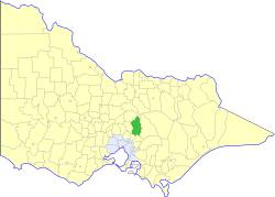
The Shire of Murrindindi is a local government area in the Hume region of Victoria, Australia, located in the north-east part of the state. It covers an area of 3,880 square kilometres (1,500 sq mi) and, in June 2018, had a population of 14,478. It includes the towns of Alexandra, Buxton, Eildon, Flowerdale, Kinglake, Marysville, Molesworth, Strath Creek, Taggerty, Yarck and Yea. It was formed in 1994 from the amalgamation of the Shire of Alexandra, Shire of Yea, and parts of the Shire of Broadford, Shire of Eltham, Shire of Euroa, Shire of Healesville and City of Whittlesea.

The Goulburn River, a major inland perennial river of the Goulburn Broken catchment, part of the Murray-Darling basin, is located in the Alpine, Northern Country/North Central, and Southern Riverina regions of the Australian state of Victoria. The headwaters of the Goulburn River rise in the western end of the Victorian Alps, below the peak of Corn Hill before descending to flow into the Murray River near Echuca, making it the longest river in Victoria at 654 kilometres (406 mi). The river is impounded by the Eildon Dam to create Lake Eildon, the Eildon Pondage, the Goulburn Weir and Waranga Basin.

The Avoca River, an inland intermittent river of the north–central catchment, part of the Murray-Darling basin, is located in the lower Riverina bioregion and Central Highlands and Wimmera regions of the Australian state of Victoria. The headwaters of the Avoca River rise on the northern slopes of the Pyrenees Range and descend to flow into the ephemeral Kerang Lakes.
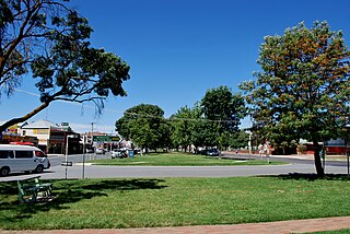
Yea is a town in Victoria, Australia 100 kilometres (62 mi) north-east of the state capital Melbourne at the junction of the Goulburn Valley Highway and the Melba Highway, in the Shire of Murrindindi local government area. In an area originally inhabited by the Taungurung people, it was first visited by Europeans of the Hume and Hovell expedition in 1824, and within 15 years most of the land in the area had been taken up by graziers. Surveyed in 1855, the township grew as a service centre for grazing, gold-mining and timber-getting in the area.

Alexandra is a town in north-east Victoria, Australia, 130 kilometres north-east of the State Capital, Melbourne. It is located at the junction of the Goulburn Valley Highway (B340) and Maroondah Highway (B360), in the Shire of Murrindindi local government area. At the 2016 census, the town had a population of 2,695 and the broader area a population of 6420.

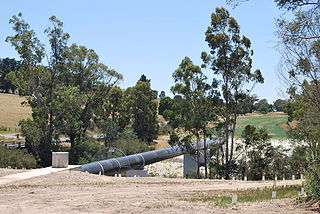
The Rubicon Hydroelectric Scheme is a small run-of-the-river hydroelectric scheme located on the Rubicon and Royston Rivers, north east of Melbourne, 40 km (25 mi) south-west of Alexandra, Victoria, Australia. The scheme commenced in 1922, and was the first state-owned hydroelectric scheme to generate electricity in mainland Australia, and among the first in the world to be remotely controlled. For the first ten years of its operation it supplied on average 16.9% of electricity generated by the State Electricity Commission of Victoria. It is now owned and operated by AGL Energy and contributes approximately 0.02% of Victoria's energy supply.

The Bemm River is a perennial river, located in the East Gippsland region of the Australian state of Victoria.

The Lerderderg River is a perennial river of the Port Phillip catchment, located in the Western District region of the Australian state of Victoria.

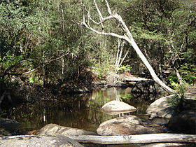
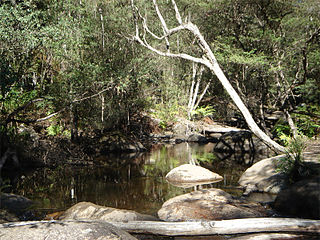
The Cathedral Range State Park located in Victoria, Australia, approximately 100 kilometres (62 mi) north-east of Melbourne. It is situated between the towns of Buxton and Taggerty and runs parallel to the Maroondah Highway. The Cathedral Range was declared a State Park on 26 April 1979. It consists of 3,577 hectares and contains the rugged Razorback and spectacular peaks of the Cathedral Range, Little River and forested hills of the Blue Range. Due to its proximity to Melbourne the Cathedral Ranges are a popular destination for both day and weekend adventures. Bushwalking, camping, rock climbing and abseiling are some of the more popular activities available. Cathedral Range State Park is listed as Category II under the IUCN World Commission on Protected Areas and is an example of a park that can be used for recreation, education and conserving natural ecosystems.

The Toorongo Falls Reserve protects two waterfalls on the Toorongo River and the Little Toorongo River in Gippsland, Victoria, Australia. It is located approximately 6 kilometres (3.7 mi) north-east of the town of Noojee, approximately 100 kilometres (62 mi) east of Melbourne.
The Shire of Yea was a local government area about 110 kilometres (68 mi) northeast of Melbourne, the state capital of Victoria, Australia. The shire covered an area of 1,392.32 square kilometres (537.6 sq mi), and existed from 1869 until 1994. The shire's population was dominated by the town of Yea.
Murrindindi is a locality along the valley of the Murrindindi River in Victoria, in eastern Australia in the Murrindindi local government area. The nearest town is Yea. At the 2016 census, the suburb of Murrindindi had a population of 107.
The Timbarra River is a perennial river of the Mitchell River catchment, located in the East Gippsland region of the Australian state of Victoria.
The Delegate River Diversion Tunnel is a Victorian gold rush diversion tunnel on the Delegate River in east Gippsland, Victoria, Australia - approximately 70 km north-east of Orbost. The river eventually runs through the township of Delegate, New South Wales. The tunnel is approximately 60 m long and diverts the river away from its original course.
The Yea River, an inland perennial river of the Goulburn Broken catchment, part of the Murray-Darling basin, is located in the lower South Eastern Highlands bioregion and Northern Country/North Central regions of the Australian state of Victoria.
The Acheron River, a minor inland perennial river of the Goulburn Broken catchment, part of the Murray-Darling basin, is located in the lower South Eastern Highlands bioregion and Northern Country/North Central regions of the Australian state of Victoria. The headwaters of the Acheron River rise on the north–western slopes of the Yarra Ranges, below The Knobs and descend to flow into the Goulburn River near Alexandra.
The Chandlers Creek, a perennial stream that is part of the Clarence River catchment, is located in the Northern Tablelands region of New South Wales, Australia.

The Toolangi State Forest region in southern Australia extends from Mount Monda in the south up to Murrindindi in the north and includes the township of Toolangi. The forest is mainly eucalypt forest that has regrown from the 1939 Victoria Bushfires.
The Taponga River, an inland perennial river of the Goulburn Broken catchment, part of the Murray-Darling basin, is located in the lower South Eastern Highlands bioregion, Alpine and Northern Country/North Central regions of the Australian state of Victoria. It flows from the northwestern slopes of the Australian Alps, north and joins with the Big River.

The Campaspe River, an inland intermittent river of the north–central catchment, part of the Murray-Darling basin, is located in the lower Riverina bioregion and Central Highlands and Wimmera regions of the Australian state of Victoria. The headwaters of the Campaspe River rise on the northern slopes of the Great Dividing Range and descend to flow north into the Murray River, Australia's longest river, near Echuca.