
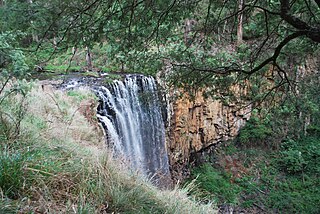
The Lake Eildon National Park is a national park in the Central Highlands region of Victoria, Australia. The 27,750-hectare (68,600-acre) national park is set in the northern foothills of the Central Highlands, approximately 111 kilometres (69 mi) northeast of Melbourne and abuts the shores of Lake Eildon.

The Goulburn River, a major inland perennial river of the Goulburn Broken catchment, part of the Murray-Darling basin, is located in the Alpine, Northern Country/North Central, and Southern Riverina regions of the Australian state of Victoria. The headwaters of the Goulburn River rise in the western end of the Victorian Alps, below the peak of Corn Hill before descending to flow into the Murray River near Echuca, making it the longest river in Victoria at 654 kilometres (406 mi). The river is impounded by the Eildon Dam to create Lake Eildon, the Eildon Pondage, the Goulburn Weir and Waranga Basin.

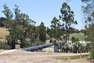
The Eildon Dam is a rock and earth-fill embankment dam with a controlled spillway across the Goulburn River, is located between the regional towns of Mansfield and Eildon within Lake Eildon National Park, in the Alpine region of Victoria, Australia. The dam's purpose is for the supply of potable water, irrigation, and the generation of hydroelectricity. The impounded reservoir is called Lake Eildon.

The Avoca River, an inland intermittent river of the north–central catchment, part of the Murray-Darling basin, is located in the lower Riverina bioregion and Central Highlands and Wimmera regions of the Australian state of Victoria. The headwaters of the Avoca River rise on the northern slopes of the Pyrenees Range and descend to flow into the ephemeral Kerang Lakes.
Eildon is a town in central Victoria, Australia. It is located near Lake Eildon, on the Goulburn Valley Highway, in the Shire of Murrindindi local government area. At the 2016 census, Eildon had a population of 974.

The Loddon River, an inland river of the north–central catchment, part of the Murray-Darling basin, is located in the lower Riverina bioregion and Central Highlands and Loddon Mallee regions of the Australian state of Victoria. The headwaters of the Loddon River rise on the northern slopes of the Great Dividing Range east of Daylesford and descend to flow north into the Little Murray River, near Swan Hill. The river is impounded by the Cairn Curran and Laanecoorie reservoirs. The Tullaroop Creek tributary, which joins just above Laanecoorie Reservoir, is impounded by the Tullaroop Reservoir (72,950ML).
The Goulburn Valley is a sub-region, part of the Hume region of the Australian state of Victoria. The sub-region consists of those areas in the catchment of the Goulburn River and other nearby streams, and is part of the Murray-Darling Basin. The Goulburn Valley is bordered on the south by the Great Dividing Range and to the north by the Murray River, the state border with New South Wales. The sub-region is one of Australia's most productive and intensively farmed areas and is predominantly irrigated.

The Broken River, a minor inland perennial river of the Goulburn Broken catchment, part of the Murray–Darling basin, is located in the Alpine and Northern Country/North Central regions of the Australian state of Victoria. The headwaters of the Broken River rise in the western slopes of the Victorian Alps, near Bald Hill and descend to flow into the Goulburn River near Shepparton. The river is impounded by the Nillahcootie Dam to create Lake Nillahcootie and Benalla Dam to create Lake Benalla.

The King River, a perennial river of the North-East Murray catchment of the Murray-Darling basin, is located in the Alpine and Hume regions of Victoria, Australia. It flows from the northwestern slopes of the Alpine National Park in the Australian Alps, through the King Valley, and joining with the Ovens River at the rural city of Wangaratta.

The Wimmera River, an inland intermittent river of the Wimmera catchment, is located in the Grampians and Wimmera regions of the Australian state of Victoria. Rising in the Pyrenees, on the northern slopes of the Great Dividing Range, the Wimmera River flows generally north by west and drains into Lake Hindmarsh and Lake Albacutya, a series of ephemeral lakes that, whilst they do not directly empty into a defined watercourse, form part of the Murray River catchment of the Murray-Darling basin.
The Coliban River, an inland perennial river of the north–central catchment, part of the Murray-Darling basin, is located in the lower Riverina bioregion and Central Highlands region of the Australian state of Victoria. The headwaters of the Coliban River rise on the northern slopes of the Great Dividing Range and descend to flow north into the Campaspe River with the impounded Lake Eppalock.

The Howqua River, a minor inland perennial river of the Goulburn Broken catchment, part of the Murray-Darling basin, is located in the Alpine region of the Australian state of Victoria. The headwaters of the Howqua River rise below Mount Howitt in the western slopes of the Victorian Alps, and descend to flow into the Goulburn River within Lake Eildon.
The Yea River, an inland perennial river of the Goulburn Broken catchment, part of the Murray-Darling basin, is located in the lower South Eastern Highlands bioregion and Northern Country/North Central regions of the Australian state of Victoria.
The Acheron River, a minor inland perennial river of the Goulburn Broken catchment, part of the Murray-Darling basin, is located in the lower South Eastern Highlands bioregion and Northern Country/North Central regions of the Australian state of Victoria. The headwaters of the Acheron River rise on the north–western slopes of the Yarra Ranges, below The Knobs and descend to flow into the Goulburn River near Alexandra.
The Taponga River, an inland perennial river of the Goulburn Broken catchment, part of the Murray-Darling basin, is located in the lower South Eastern Highlands bioregion, Alpine and Northern Country/North Central regions of the Australian state of Victoria. It flows from the northwestern slopes of the Australian Alps, north and joins with the Big River.

The Big River, an inland perennial river of the Goulburn Broken catchment, part of the Murray-Darling basin, is located in the lower South Eastern Highlands bioregion and Northern Country/North Central regions of the Australian state of Victoria. The headwaters of the Big River rise on the northern slopes of the Yarra Ranges and descend to flow into the Goulburn River within Lake Eildon.
The Black River, an inland perennial river of the Goulburn Broken catchment, part of the Murray-Darling basin, is located in the lower South Eastern Highlands bioregion and Northern Country/North Central regions of the Australian state of Victoria. The headwaters of the Black River rise on the northern slopes of the Yarra Ranges and descend to flow into the Goulburn River within the Yarra Ranges National Park.
The Murrindindi River, an inland perennial river of the Goulburn Broken catchment, part of the Murray-Darling basin, is located in the lower South Eastern Highlands bioregion and Northern Country/North Central regions of the Australian state of Victoria. The headwaters of the Murrindindi River rise on the western slopes of the Victorian Alps and descend to flow into the Yea River.
The Royston River, an inland perennial river of the Goulburn Broken catchment, part of the Murray-Darling basin, is located in the lower South Eastern Highlands bioregion and Northern Country/North Central regions of the Australian state of Victoria. The headwaters of the Royston River rise on the western slopes of the Victorian Alps and descend to flow into the Rubicon River.

The Campaspe River, an inland intermittent river of the north–central catchment, part of the Murray-Darling basin, is located in the lower Riverina bioregion and Central Highlands and Wimmera regions of the Australian state of Victoria. The headwaters of the Campaspe River rise on the northern slopes of the Great Dividing Range and descend to flow north into the Murray River, Australia's longest river, near Echuca.

