
The Georges River, also known as Tucoerah River, is an intermediate tide-dominated drowned valley estuary, located to the south and west of Sydney, New South Wales, Australia.

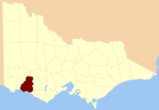
The Shire of Moyne is a local government area in the Barwon South West region of Victoria, Australia, located in the south-western part of the state. It covers an area of 5,481 square kilometres (2,116 sq mi) and in June 2018 had a population of 16,887. It includes the towns of Port Fairy, Koroit, Mortlake, Macarthur, Peterborough, Caramut, Ellerslie, Framlingham, Garvoc, Hawkesdale, Kirkstall, Panmure, Mailors Flat, Purnim, Wangoom and Woolsthorpe. It also entirely surrounds the City of Warrnambool, a separate local government area. It was formed in 1994 from the amalgamation of the Shire of Belfast, Shire of Minhamite, Borough of Port Fairy, and parts of the Shire of Mortlake, Shire of Warrnambool, Shire of Dundas, Shire of Mount Rouse and Shire of Hampden.
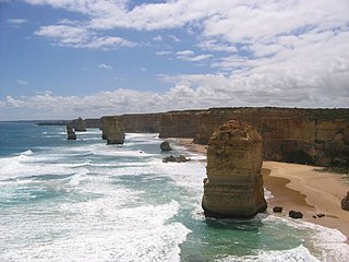
The Western District comprises western regions of the Australian state of Victoria. It is said to be an ill–defined district, sometimes incorrectly referred to as an economic region,. The district is located within parts of the Barwon South West and the Grampians regions; extending from the south-west corner of the state to Ballarat in the east and as far north as Ararat. The district is bounded by the Wimmera district in the north, by the Goldfields district in the east, by Bass Strait and the Southern Ocean in the south, and by the South Australian border in the west. The district is well known for the production of wool. The most populated city in the Western District is the Ballarat region, with 96,940 inhabitants.

Codrington Wind Farm is a wind farm near Yambuk on the coast of south-western Victoria, Australia. Completed in June 2001, the 18.2MW installation of 14 wind turbines generates 51 GWh annually, for a capital cost of A$30 million by Pacific Hydro being the first fully private investment in a wind farm in Australia. When opened it was Australia's largest wind farm and the first in Victoria.
Deen Maar Indigenous Protected Area is an Indigenous Protected Area (IPA) located in south-west Victoria, Australia on land bounded by the Eumeralla River and Bass Strait. The IPA has an area of 4.53 square kilometres. The country consists of limestone ridges, wetlands, lakes and sand dunes. It is the traditional home of the Peek Whurrong speakers of the Dhauwurdwurung (Gunditjmara) Nation. The IPA takes its name from Deen Maar Island, which lies a short distance off the coast. It is classified as an IUCN Category VI protected area. It is within the boundaries of the Yambuk Important Bird Area, identified as such by BirdLife International because of its importance for the conservation of threatened species such as the orange-bellied parrot and hooded plover.

The Glenelg River, a perennial river of the Glenelg Hopkins catchment, is located in the Australian states of Victoria and South Australia.
Yambuk is a town in Victoria, Australia.
The County of Villiers is one of the 37 counties of Victoria which are part of the cadastral divisions of Australia, used for land titles. It includes the area to the north of Warrnambool, and to the west of the Hopkins River. The county was proclaimed in 1849.

The Wannon River, a perennial river of the Glenelg Hopkins catchment, is located in the Western District of Victoria, Australia.

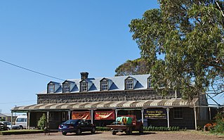
Macarthur originally known as Eumeralla, is a town in the Western District of Victoria, Australia on the Hamilton-Port Fairy Road. It is in the Shire of Moyne local government area and the federal Division of Wannon. At the 2016 census, Macarthur and the surrounding area had a population of 522.
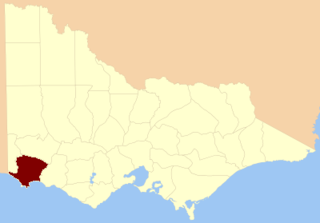
The County of Normanby in Victoria, is one of the 37 counties of Victoria which are part of the cadastral divisions of Australia, used for land titles. The county is in the Western District of Victoria bounded by the Glenelg River in the west and the Eumeralla River in the east, by a line through Casterton and Hamilton in the north, and by Bass Strait to the south. Larger towns include Hamilton, Portland and Heywood. The county was proclaimed in 1853, but it was known earlier since the 1849 proclamation of Follett County and Dundas County referred to its boundaries.
Vineyard Creek, a northern tributary of the Parramatta River, is a creek in Sydney, Australia.
Budj Bim, also known as Mount Eccles, is a dormant volcano near Macarthur in southwestern Victoria, Australia. It lies within the geologically-defined area known as the Newer Volcanics Province, which is the youngest volcanic area in Australia and stretches from western Victoria to south-eastern South Australia.
The Shaw River, a perennial river of the Glenelg Hopkins catchment, is located in the Western District of Victoria, Australia.

The Cumberland River is a perennial river of the Corangamite catchment, located in The Otways region of the Australian state of Victoria.

The O'Shannassy River is a perennial river of the Port Phillip catchment, located in the north-eastern Greater Metropolitan Melbourne region of the Australian state of Victoria.
The Morwell River is a perennial river of the West Gippsland catchment, located in the West Gippsland and South Gippsland regions of the Australian state of Victoria.

The Yambuk Important Bird Area comprises a 10 km2 tract of coastal land fronting Bass Strait in south-western Victoria, south-eastern Australia. It lies some 20 km west of the town of Port Fairy and encompasses the lower reaches of the Eumeralla River and Lake Yambuk.
The Eumeralla Wars were the violent encounters over the possession of land between British colonists and Gunditjmara Aboriginal people in what is now called the Western District area of south west Victoria.
The Eastern Maar people are a group of Aboriginal Australian peoples whose traditional lands are in the south-western part of state of Victoria, Australia. It is a name adopted by a number of Aboriginal Victorian groups who identify as Maar, including Eastern Gunditjmara, Tjap Wurrung, Peek Whurrong, Kirrae Whurrung, Kuurn Kopan Noot and/or Yarro waetch people.The word "Maar" means "the people".
