
Dartmouth Dam is a large rock-fill embankment dam with an uncontrolled chute spillway across the Mitta Mitta, Gibbo and Dart rivers, the Morass Creek and a number of small tributaries. The dam is located near Mount Bogong in the north-east of the Australian state of Victoria. The dam's purpose includes irrigation, the generation of hydro-electric power, water supply and conservation. The impounded reservoir is called Dartmouth Reservoir, sometimes called Lake Dartmouth. The Dartmouth Power Station, a hydro-electric power station that generates power to the national grid, is located near the dam wall.
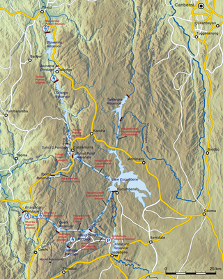
The Snowy Mountains Scheme, also known as the Snowy Hydro or the Snowy scheme, is a hydroelectricity and irrigation complex in south-east Australia. Near the border of New South Wales and Victoria, the scheme consists of sixteen major dams; nine power stations; two pumping stations; and 225 kilometres (140 mi) of tunnels, pipelines and aqueducts that were constructed between 1949 and 1974. The Scheme was completed under the supervision of Chief Engineer, Sir William Hudson. It is the largest engineering project undertaken in Australia.

The Eildon Dam is a rock and earth-fill embankment dam with a controlled spillway, located on the Goulburn River between the regional towns of Mansfield and Eildon within Lake Eildon National Park, in the Alpine region of Victoria, Australia. The dam's purpose is for the supply of potable water, irrigation, and the generation of hydroelectricity. The impounded reservoir is called Lake Eildon.The first cut of ground was done by Mr Bain and Mr MacLean from Scotland.

The Snowy River is a major river in south-eastern Australia. It originates on the slopes of Mount Kosciuszko, Australia's highest mainland peak, draining the eastern slopes of the Snowy Mountains in New South Wales, before flowing through the Alpine National Park and the Snowy River National Park in Victoria and emptying into Bass Strait.

The Avoca River, an inland intermittent river of the north–central catchment, part of the Murray-Darling basin, is located in the lower Riverina bioregion and Central Highlands and Wimmera regions of the Australian state of Victoria. The headwaters of the Avoca River rise on the northern slopes of the Pyrenees Range and descend to flow into the ephemeral Kerang Lakes.

The Waranga Dam is a major earthfill embankment dam with an uncontrolled spillway located approximately 150 kilometres (93 mi) north of Melbourne in the North Central region of the Australian state of Victoria. The impounded off-stream reservoir is Waranga Basin and forms part of the Goulburn River irrigation system, irrigating an area of 626 square kilometres (242 sq mi). The dam and reservoir are located in Shire of Campaspe near the City of Greater Shepparton and is located 8 kilometres (5 mi) north-east of Rushworth, 12 kilometres (7.5 mi) south-west of Tatura, and near Murchison. When full, the reservoir covers an area of 58.5 square kilometres (22.6 sq mi).

Maffra is a town in Victoria, Australia, 220 kilometres (140 mi) east of Melbourne. It is in the Shire of Wellington local government area and it is the second most populous city of the Shire. It relies mainly on dairy farming and other agriculture, and is the site of one of Murray Goulburn Co-operative's eight processing plants in Victoria. Maffra is a detour off the Princes Highway and is near Sale, Stratford, Newry, Tinamba, Heyfield and Rosedale. At the 2016 census, Maffra had a population of 4,316.

Wyangala Dam is a major gated rock fill with clay core embankment and gravity dam with eight radial gates and a concrete chute spillway across the Lachlan River, located in the south-western slopes region of New South Wales, Australia. The dam's purpose includes flood mitigation, hydro-power, irrigation, water supply and conservation. The impounded reservoir is called Lake Wyangala.

The Somerset Dam is a mass concrete gravity dam with a gated spillway across the Stanley River in Queensland, Australia. It is within the locality of Somerset Dam in the Somerset Region in South East Queensland. The main purpose of the dam is the supply of potable water for the Brisbane, Gold Coast and Logan City regions. Additionally, the dam provides for flood mitigation, recreation and for the generation of hydroelectricity. The impounded reservoir is called Lake Somerset.

The Wivenhoe Dam is a rock and earth-fill embankment dam with a concrete spillway across the Brisbane River in South East Queensland, Australia. The dam takes it names from the local Wivenhoe Pocket rural community. The dam wall is located about 80 kilometres (50 mi) by road from the centre of Brisbane. The primary purpose of the dam is the supply of potable water for the Brisbane and Ipswich regions. The dam also provides for flood mitigation control, hydroelectricity, and recreation. The impounded reservoir is called Lake Wivenhoe and the dam, the lake and a narrow strip of surrounding land forms a locality also called Lake Wivenhoe.

The Thomson River, a perennial river of the West Gippsland catchment, is located in the Gippsland region of the Australian state of Victoria.

The Maroon Dam is a rock and earth-fill embankment dam with an un-gated spillway across the Burnett Creek that is located in the South East region of Queensland, Australia. The main purpose of the dam is for irrigation of the Scenic Rim Regional Council region. The impounded reservoir is also called Maroon Dam.
Pacific Blue is an electricity generation and retailing company headquartered in Melbourne, Australia. The company was founded in 1992 and was soon floated on the Australian Stock Exchange, it was later bought by a consortium of industry superannuation funds and delisted. It is now owned by China's State Power Investment Corporation.
The William Hovell Dam is a rock and earth-fill embankment dam with a flip bucket chute spillway across the King River, operated by Pacific Blue and located in the Hume region of Victoria, Australia. The purposes of the dam are for irrigation and the generation of hydroelectricity. The impounded reservoir is called Lake William Hovell.
The Nillahcootie Dam, a rock and earth-fill embankment dam with a unique Gothic arch-shaped crest spillway across the Broken River that is located near Mansfield, in the Alpine region of Victoria, Australia. The dam's purpose is for the supply of potable water and for irrigation. The impounded reservoir is called Lake Nillahcootie.
Cardinia Reservoir is an Australian man-made water supply saddle dam reservoir. The 287,000 ML water store is located in Emerald–Clematis–Dewhurst in south-eastern suburbs of Melbourne, Victoria. Construction started in May 1970 and was completed in 1973 at a cost of more than A$11.4 million. The dam that creates the impoundment is called the Cardinia Dam.
The Fairbairn Dam is an earth-filled embankment dam across the Nogoa River, located southwest of Emerald in Central Queensland, Australia. Constructed in 1972 for the primary purpose of irrigation, the impoundment created by the dam serves as one of the major potable water supplies for the region and assists with some flood mitigation.

The Coolmunda Dam is an earth–fill embankment dam with a gated spillway across the Macintrye Brook, a tributary of the Dumaresq River, that is located on Darling Downs in Coolmunda, Goondiwindi Region, Queensland, Australia. The main purposes of the dam are for irrigation and potable water supply. The impounded reservoir is called the Lake Coolmunda.
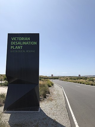
The Victorian Desalination Plant is a water desalination plant in Dalyston, on the Bass Coast in southern Victoria, Australia. The project was announced by Premier Steve Bracks in June 2007, at the height of the millennium drought when Melbourne's water storage levels dropped to 28.4%, a drop of more than 20% from the previous year. Increased winter-spring rains after mid-2007 took water storage levels above 40%, but it was not until 2011 that storages returned to pre-2006 levels.

The Macalister River, a perennial river of the West Gippsland catchment, is located in the Alpine and Gippsland regions of the Australian state of Victoria.

