Dartmouth Dam is a large rock-fill embankment dam with an uncontrolled chute spillway across the Mitta Mitta, Gibbo and Dart rivers, the Morass Creek and a number of small tributaries. The dam is located near Mount Bogong in the north-east of the Australian state of Victoria. The dam's purpose includes irrigation, the generation of hydro-electric power, water supply and conservation. The impounded reservoir is called Dartmouth Reservoir, sometimes called Lake Dartmouth. The Dartmouth Power Station, a hydro-electric power station that generates power to the national grid, is located near the dam wall.

Hume Dam, formerly the Hume Weir, is a major dam across the Murray River downstream of its junction with the Mitta River in the Riverina region of New South Wales, Australia. The dam's purpose includes flood mitigation, hydro-power, irrigation, water supply and conservation. The impounded reservoir is called Lake Hume, formerly the Hume Reservoir. It is a gated concrete gravity dam with four earth embankments and twenty-nine vertical undershot gated concrete overflow spillways.

The Eildon Dam is a rock and earth-fill embankment dam with a controlled spillway across the Goulburn River, is located between the regional towns of Mansfield and Eildon within Lake Eildon National Park, in the Alpine region of Victoria, Australia. The dam's purpose is for the supply of potable water, irrigation, and the generation of hydroelectricity. The impounded reservoir is called Lake Eildon.
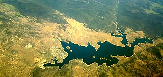
The Waranga Dam is a major earthfill embankment dam with an uncontrolled spillway located approximately 150 kilometres (93 mi) north of Melbourne in the North Central region of the Australian state of Victoria. The impounded off-stream reservoir is Waranga Basin and forms part of the Goulburn River irrigation system, irrigating an area of 626 square kilometres (242 sq mi). The dam and reservoir are located in Shire of Campaspe near the City of Greater Shepparton and is located 8 kilometres (5.0 mi) northeast of Rushworth, 12 kilometres (7.5 mi) southwest of Tatura, and near Murchison. When full, the reservoir covers an area of 58.5 square kilometres (22.6 sq mi).

Lake Eppalock is an Australian reservoir in North Central Victoria about 130 kilometres (81 mi) northwest of Melbourne. It was formed by the construction of a major earth and rockfill embankment dam, known as Eppalock Dam, with a controlled chute spillway across the Campaspe and the Coliban rivers. The lake is situated between the regional population centres of Bendigo and Heathcote and serves as a major water storage facility for both places, as well as the Campaspe irrigation district. The lake also serves as a popular sports and recreational facility.
Lostock Dam is a minor rockfill and clay core embankment dam with a concrete lined, flip bucket spillway across the Paterson River upstream of the village of East Gresford in the Hunter region of New South Wales, Australia. The dam's purpose includes flood mitigation, irrigation, water supply and conservation. Mini hydro-power facilities were retrofitted in 2010. The impounded reservoir is also called Lostock Dam.

The Blowering Dam is a major ungated rock fill with clay core embankment dam with concrete chute spillway impounding a reservoir under the same name. It is located on the Tumut River upstream of Tumut in the Snowy Mountains region of New South Wales, Australia. Purposes for the dam include flood mitigation, hydro-power, irrigation, water supply and conservation. The dam is part of the Snowy Mountains Scheme, a vast hydroelectricity and irrigation complex constructed in south-east Australia between 1949 and 1974 and now run by Snowy Hydro.
Jindabyne Dam is a major ungated rockfill embankment dam across the Snowy River in the Snowy Mountains of New South Wales, Australia. The dam's main purpose is for the generation of hydro-power and is one of the sixteen major dams that comprise the Snowy Mountains Scheme, a vast hydroelectricity and irrigation complex constructed in south-east Australia between 1949 and 1974 and now run by Snowy Hydro.

Eucumbene Dam is a major gated earthfill embankment dam with an overflow ski-jump and bucket spillway with two vertical lift gates across the Eucumbene River in the Snowy Mountains of New South Wales, Australia. The dam's main purpose is for the generation of hydro-power and is one of the sixteen major dams that comprise the Snowy Mountains Scheme, a vast hydroelectricity and irrigation complex constructed in south-east Australia between 1949 and 1974 and now run by Snowy Hydro.

The King River, a perennial river of the North-East Murray catchment of the Murray-Darling basin, is located in the Alpine and Hume regions of Victoria, Australia. It flows from the northwestern slopes of the Alpine National Park in the Australian Alps, through the King Valley, and joining with the Ovens River at the rural city of Wangaratta.
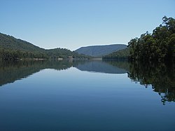
Cochrane Dam is a minor earthfill embankment dam with concrete spillway across Georges Creek, located in the South Coast region of New South Wales, Australia. The main purpose of the dam is to supply water for hydro-power at the downstream Brown Mountain Power Station and for irrigation purposes. The impounded reservoir is called Cochrane Lake.
The Nillahcootie Dam, a rock and earth-fill embankment dam with a unique Gothic arch-shaped crest spillway across the Broken River that is located near Mansfield, in the Alpine region of Victoria, Australia. The dam's purpose is for the supply of potable water and for irrigation. The impounded reservoir is called Lake Nillahcootie.

Talbingo Dam is a major ungated rock fill with clay core embankment dam with concrete chute spillway across the Tumut River upstream of Talbingo in the Snowy Mountains region of New South Wales, Australia. The impounded reservoir is called Talbingo Reservoir.
The Fairbairn Dam is an earth-filled embankment dam across the Nogoa River, located southwest of Emerald in Central Queensland, Australia. Constructed in 1972 for the primary purpose of irrigation, the impoundment created by the dam serves as one of the major potable water supplies for the region and assists with some flood mitigation.
Deep Creek Dam is a major ungated concrete gravity dam across the Deep Creek in the Snowy Mountains of New South Wales, Australia. The dam's main purpose is for the diversion of water for generation of hydro-power and is the smallest of the sixteen major dams that comprise the Snowy Mountains Scheme, a vast hydroelectricity and irrigation complex constructed in south-east Australia between 1949 and 1974 and now run by Snowy Hydro.
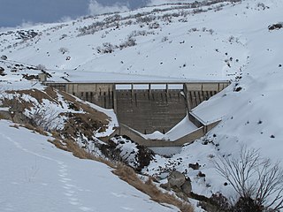
Guthega Dam is concrete gravity dam with an uncontrolled spillway across the Snowy River in the Snowy Mountains of New South Wales, Australia. The dam's main purpose is for the storage of water used in the generation of hydro-power. It is the first to be completed of the sixteen major dams of the Snowy Mountains Scheme, a vast hydroelectricity and irrigation complex constructed in south-east Australia between 1949 and 1974 and now run by Snowy Hydro.
Island Bend Dam is a major ungated concrete gravity dam with a controlled spillway across the Snowy River in the Snowy Mountains region of New South Wales, Australia. The dam's main purpose is for the diversion of water for generation of hydro-power and is one of the sixteen major dams that comprise the Snowy Mountains Scheme, a vast hydroelectricity and irrigation complex constructed in south-east Australia between 1949 and 1974 and now run by Snowy Hydro.
Khancoban Dam is a major ungated earthfill embankment dam with a controlled spillway across the Swampy Plain River in the Snowy Mountains region of New South Wales, Australia. The dam's main purpose is for the generation of hydro-power and is one of the sixteen major dams that comprise the Snowy Mountains Scheme, a vast hydroelectricity and irrigation complex constructed in south-east Australia between 1949 and 1974 and now run by Snowy Hydro.
Murray Two Dam or Murray 2 Dam is a major ungated concrete arch dam with a controlled spillway across Khancoban Bank, a diverted flow of the Snowy and Geehi rivers in the Snowy Mountains region of New South Wales, Australia. The impounded reservoir is called the Murray Two Pondage or Murray 2 Pondage.

The Glenmaggie Dam is a concrete block foundation gravity dam with 14 radial arm gates across the Macalister River, located near Maffra, Central Gippsland, in the Australian state of Victoria. The dam's purpose includes irrigation, the generation of hydro-electric power, water supply and conservation. The impounded reservoir is called Lake Glenmaggie.