Melbourne Water is a Victorian Government-owned statutory authority that controls and manages much of the water bodies and supplies in metropolitan Melbourne, Victoria, Australia, including the reservoirs, lakes, wetlands, canals and urban creeks, and the sewerage and drainage systems that services the city.

Lake Eppalock is an Australian reservoir in North Central Victoria about 130 kilometres (81 mi) northwest of Melbourne. It was formed by the construction of a major earth and rockfill embankment dam, known as Eppalock Dam, with a controlled chute spillway across the Campaspe and the Coliban rivers. The lake is situated between the regional population centres of Bendigo and Heathcote and serves as a major water storage facility for both places, as well as the Campaspe irrigation district. The lake also serves as a popular sports and recreational facility.

The Upper Nepean Scheme is a series of dams and weirs in the catchments of the Cataract, Cordeaux, Avon and Nepean rivers of New South Wales, Australia. The scheme includes four dams and two weirs, and a gravity-fed canal system that feeds into a large storage reservoir to provide water to the Macarthur and Illawarra regions, the Wollondilly Shire, and metropolitan Sydney. The four dams and associated infrastructure are individually listed on the New South Wales State Heritage Register.
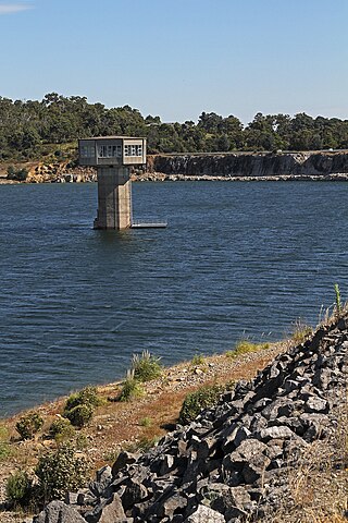
Tallowa Dam, completed in 1976, is a concrete gravity dam with central overflow spillway, located on the Shoalhaven River, downstream from the river's confluence with the Kangaroo River. The dam wall of 325 cubic metres (11,500 cu ft) is 43 metres (141 ft) high and 528 metres (1,732 ft) in length. At 100% capacity, the dam wall holds back approximately 85,500 megalitres and creates the impounded reservoir of Lake Yarrunga that has a surface area of 831 hectares, drawn from a catchment area of 5,750 square kilometres (2,220 sq mi). The spillway has a discharge capacity of 27,600 cubic metres per second (970,000 cu ft/s).
The Silvan Reservoir is located in Silvan about 40 kilometres (25 mi) east of Melbourne, Victoria, Australia. It has a capacity of 40,000 ML (1.4 billion cu ft). The reservoir is operated by Melbourne Water.

Yan Yean Reservoir is the oldest water supply for the city of Melbourne, Victoria, Australia. At the time of its completion in 1857 it was the largest artificial reservoir in the world. It is 30 kilometres (19 mi) north of the city within the eponymous locality of Yan Yean, and is built on the Plenty River, a tributary of the Yarra River. An embankment 9.5 metres (31 ft) high holds back 30,000 ML (1.1 billion cu ft) of water.

The Thomson Dam is a major Clay core and rockfill embankment dam with a Uncontrolled, Ogee-shaped overflow weir and chute spillway across the Thomson River, located about 130 kilometres (81 mi) east of Melbourne in the West Gippsland region of the Australian state of Victoria. The reservoir created by the dam is officially called Thomson Reservoir, sometimes called Lake Thomson.
Cairn Curran reservoir is situated along the Loddon River near the townships of Baringhup, Newstead and Welshmans Reef in Victoria, Australia. Constructed between 1947 and 1956.
Cardinia Reservoir is an Australian man-made water supply saddle dam reservoir. The 287,000 ML water store is located in Emerald–Clematis–Dewhurst in south-eastern suburbs of Melbourne, Victoria. Construction started in May 1970 and was completed in 1973 at a cost of more than A$11.4 million. The dam that creates the impoundment is called the Cardinia Dam.
Lauriston Reservoir is a reservoir in Victoria, Australia, with a maximum capacity of 19,800 megalitres. The dam that created it, located 9 km west of Kyneton along Lauriston Reservoir Road, was constructed from 1938 to 1941 and has a spillway that measures 77 metres. The site is a popular picnic ground as one can fish there, and barbecue facilities are available. The reservoir is known to contain redfin perch, rainbow and brown trout, roach and cod.

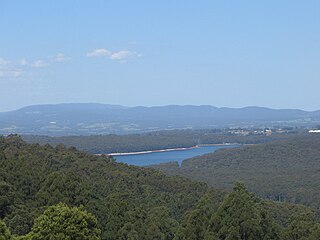
Melbourne is the capital city of southeastern Australian state of Victoria and also the nation's second most populous city, and has been consistently voted one of the most liveable cities in the world. Located on the northern/eastern coastal plains of Port Phillip Bay, the city is the one of the drier capital cities in Australia, but due to its relatively flat terrain and the runoffs fed from surrounding highlands, still has many lakes, ponds and wetlands, mainly managed by Melbourne Water and Parks Victoria. The larger waterbodies are used for water sports, mostly boating but some are used for recreational activities like swimming, water skiing or model boating.

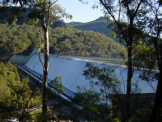
The Maroondah Dam is a rock-foundation concrete gravity dam with an uncontrolled rock-chute spillway across the Watts River, located in the Central region of the Australian state of Victoria. The storage created by the dam is called Maroondah Reservoir. The principal purpose of the dam and its reservoir is to supply potable water for Greater Metropolitan Melbourne.
As Australia's supply of freshwater is increasingly vulnerable to droughts, possibly as a result of climate change, there is an emphasis on water conservation and various regions have imposed restrictions on the use of water.

Greenvale Reservoir is an off-stream water storage dam in northern Melbourne, Victoria, Australia. It has a capacity of 27,000 ML (950 million cu ft). The dam was opened 18 April 1973 and is now managed by Melbourne Water.
The O'Shannassy Reservoir is an Australian man-made water supply dammed reservoir. The 3.123 GL water store across the O'Shannassy River is located near the locality of McMahons Creek, approximately 80 kilometres (50 mi) east of Melbourne, Victoria. The dam that creates the impoundment is called the O'Shannassy Dam.
The Watts River is a perennial river of the Port Phillip and Western Port catchment, located in the Healesville area, in the Central region of the Australian state of Victoria.
Toorourrong Reservoir is a small water supply reservoir located on the southern slopes of the Great Dividing Range approximately 40 kilometres (25 mi) north of Melbourne, Victoria, Australia. The reservoir is formed by the Toorourrong Dam across the Plenty River, and an interbasin transfer. The dam is operated by Melbourne Water and the reservoir forms part of the Melbourne water supply system. Water from the Toorourrong Reservoir flows by aqueduct to the Yan Yean Reservoir.
William Davidson (1844–1920), was an Australian civil engineer who headed the Melbourne Water Supply department, and was responsible for important improvements to Melbourne's water supply system during sustained periods of drought.

The Glenmaggie Dam is a concrete block foundation gravity dam with 14 radial arm gates across the Macalister River, located near Maffra, Central Gippsland, in the Australian state of Victoria. The dam's purpose includes irrigation, the generation of hydro-electric power, water supply and conservation. The impounded reservoir is called Lake Glenmaggie.
Water management in Victoria deals with the management of water resources in and by the Australian State of Victoria.

