
The City of Brimbank is a local government area located within the metropolitan area of Melbourne, Victoria, Australia. It comprises the western suburbs between 10 and 20 km west and northwest from the Melbourne city centre.

The Maribyrnong River is a perennial river of the Port Phillip catchment, located in the north–western suburbs of Melbourne, in the Australian state of Victoria.

Ardeer is a suburb in Melbourne, Victoria, Australia, 15 km (9.3 mi) west of Melbourne's Central Business District, located within the City of Brimbank local government area. Ardeer recorded a population of 3,170 at the 2021 census.
Kealba is a suburb in Melbourne, Victoria, Australia, 15 km (9.3 mi) north-west of Melbourne's Central Business District, located within the City of Brimbank local government area. Kealba recorded a population of 3,226 the 2021 census.

Sunshine is a suburb in Melbourne, Victoria, Australia, 12 km (7.5 mi) west of Melbourne's Central Business District, located within the City of Brimbank local government area. Sunshine recorded a population of 9,445 at the 2021 census.

The Moonee Ponds Creek is a creek and major tributary of the Yarra River running through urban Melbourne, Victoria, Australia from northern to inner suburbs. In 2004 a reporter for The Age described it as "arguably the most abused tributary of the Yarra River, and part of the true underside of Melbourne".
The Moonee Ponds Creek Trail is a shared use path for cyclists and pedestrians, which follows the Moonee Ponds Creek through the northern suburbs of Melbourne, Victoria, Australia.

The Maribyrnong River Trail is a shared use path for cyclists and pedestrians, which follows the Maribyrnong River through the north western suburbs of Melbourne, Victoria, Australia.

The Merri Creek Trail is a shared use path for cyclists and pedestrians that follows the Merri Creek through the northern suburbs of Melbourne, Victoria, Australia.

Albion is a suburb in Melbourne, Victoria, Australia, 14 km (8.7 mi) west of Melbourne's Central Business District, located within the City of Brimbank local government area. Albion recorded a population of 4,334 at the 2021 census.

Sunshine North is a suburb in Melbourne, Victoria, Australia, 13 km (8.1 mi) west of Melbourne's Central Business District, located within the City of Brimbank local government area. Sunshine North recorded a population of 12,047 at the 2021 census.
The Western Treatment Plant is a 110 km2 (42 sq mi) sewage treatment plant in Cocoroc, Victoria, Australia, 30 km (19 mi) west of Melbourne's central business district, on the coast of Port Phillip Bay. It was completed in 1897 by the Melbourne and Metropolitan Board of Works (MMBW), and is currently operated by Melbourne Water. The plant's land is bordered by the Werribee River to the east, the Princes Freeway to the north, and Avalon Airport to the west. It forms part of the Port Phillip Bay and Bellarine Peninsula Ramsar Site as a wetland of international importance. The Western Treatment Plant treats around fifty percent of Melbourne's sewage — about 485 megalitres or 393 acre-feet per day — and generates almost 40,000 megalitres or 32,000 acre-feet of recycled water a year.
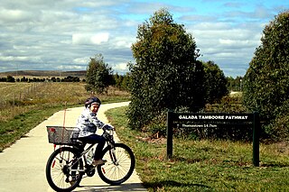
The Craigieburn Bypass Trail, is a shared use path for cyclists and pedestrians in the outer northern suburbs of Melbourne, Victoria, Australia. In 2008 it was given the local name of the Galada Tamboore Pathway - Wurundjeri for "creek waterhole" or "stream waterhole" - as it goes past the Craigieburn, Cooper street and Galada Tamboore grasslands which are all nationally significant for their plains grassland and riparian habitat for endangered and vulnerable native fauna and flora, including the critically endangered Golden Sun Moth.
The Kororoit Creek Trail is a shared use path for cyclists and pedestrians, which follows the Kororoit Creek in the inner western suburbs of Melbourne, Victoria, Australia.

The Mullum Mullum Creek Trail is a shared use path for cyclists and pedestrians, which follows Mullum Mullum Creek in the outer eastern suburbs in Melbourne, Victoria, Australia.
The Skeleton Creek Trail is a shared use path for cyclists and pedestrians, which follows Skeleton Creek as it passes through the outer south western suburbs of Point Cook and Altona Meadows in Melbourne, Victoria, Australia.
The Taylors Creek Trail is a shared use path for cyclists and pedestrians, which follows Taylors Creek in the outer north-west suburb of Taylors Lakes in Melbourne, Victoria, Australia.

The Sunshine Harvester works was an Australian factory making agricultural equipment founded by industrialist H. V. McKay, and with engineering development headed by H.B. Garde.

The H.V. McKay Memorial Gardens, originally the Sunshine Gardens, are a public space located in the Melbourne suburb of Sunshine, Victoria, Australia. Established in 1909, the Gardens are Australia's oldest remaining industrial garden and one of only two remaining in Australia, the heritage-listed gardens on Anderson Road were established by H.V. McKay as Sunshine Gardens later taken over by Brimbank City Council and renamed the H.V. McKay Memorial Gardens. The development of the gardens was not only an expression of H.V. McKay's own social philosophy but also represented a changing attitude to Urban Planning that is known as the "Garden Suburb" movement. A Friends Group was established in 2007 to rescue the Gardens from serious decline and in April 2012, local residents were campaigning to preserve the original state of the public space.

