
The Yarra River or historically, the Yarra Yarra River, is a perennial river in south-central Victoria, Australia.

The Maribyrnong River is a perennial river of the Port Phillip catchment, located in the north–western suburbs of Melbourne, in the Australian state of Victoria.

Healesville is a town in Victoria, Australia, 52 km north-east from Melbourne's central business district, located within the Shire of Yarra Ranges local government area. Healesville recorded a population of 7,589 in the 2021 census.
Don Valley is a town in Victoria, Australia, approximately 70 km east of Melbourne's central business district, located within the Shire of Yarra Ranges local government area. Don Valley recorded a population of 586 at the 2021 census.
The Bunyip River is a perennial river of the Western Port catchment, located in the West Gippsland region of the Australian state of Victoria.

The Latrobe River is a perennial river of the West Gippsland catchment, located in the West Gippsland region of the Australian state of Victoria. The Latrobe River and its associated sub-catchment is an important source for the Gippsland Lakes, draining the south eastern slopes of the Great Dividing Range.

The Plenty River is a perennial river of the Port Phillip catchment, located in the north-eastern Greater Melbourne region of the Australian state of Victoria.
Electoral district of South Melbourne was an electoral district of the Legislative Assembly in the British colony of Victoria (Australia).

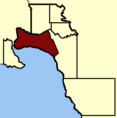
The Shire of Upper Yarra was a local government area centred on the upper reaches of the Yarra Valley, about 60 kilometres (37 mi) east of Melbourne, the state capital of Victoria, Australia, extending eastwards into Victoria's interior. The shire covered an area of 1,732 square kilometres (668.7 sq mi), and existed from 1888 until 1994.
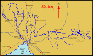
The Yarra River is a river in East-Central Victoria, Australia that flows through the city of Melbourne. This article contains explanations and lists of the river's tributaries and other geographic features. The river flows atop layers of silt that built up within an ancient river valley around 10,000-15,000 years ago.
The O'Shannassy Reservoir is an Australian man-made water supply dammed reservoir. The 3.123 GL water store across the O'Shannassy River is located near the locality of McMahons Creek, approximately 80 kilometres (50 mi) east of Melbourne, Victoria. The dam that creates the impoundment is called the O'Shannassy Dam.

The O'Shannassy River is a perennial river of the Port Phillip catchment, located in the north-eastern Greater Metropolitan Melbourne region of the Australian state of Victoria.

The Little Yarra River is a perennial river of the Port Phillip catchment, located in the Greater Metropolitan Melbourne region of the Australian state of Victoria.
The Watts River is a perennial river of the Port Phillip and Western Port catchment, located in the Healesville area, in the Central region of the Australian state of Victoria.
The Acheron River, a minor inland perennial river of the Goulburn Broken catchment, part of the Murray-Darling basin, is located in the lower South Eastern Highlands bioregion and Northern Country/North Central regions of the Australian state of Victoria. The headwaters of the Acheron River rise on the north–western slopes of the Yarra Ranges, below The Knobs and descend to flow into the Goulburn River near Alexandra.
The Tarago River is a perennial river of the Western Port catchment, located in the West Gippsland region of the Australian state of Victoria.
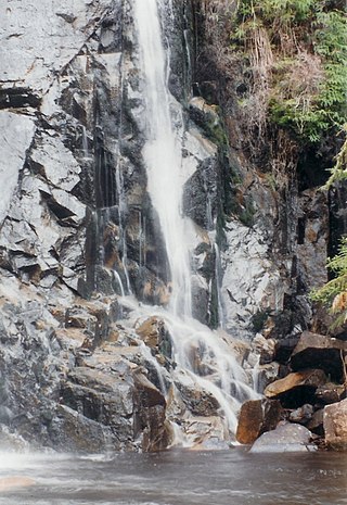
The Steavenson River, sometimes incorrectly referred to as Steavensons River, a minor inland perennial river of the Goulburn Broken catchment, part of the Murray-Darling basin, is located in the lower South Eastern Highlands bioregion and Northern Country/North Central regions of the Australian state of Victoria. The headwaters of the Steavenson River rise on the north–western slopes of the Yarra Ranges, below Mount Edgar and descend to flow into the Acheron River near Buxton.
The Taggerty River, a minor inland perennial river of the Goulburn Broken catchment, part of the Murray-Darling basin, is located in the lower South Eastern Highlands bioregion and Northern Country/North Central regions of the Australian state of Victoria. The headwaters of the Taggerty River rise on the north–western slopes of the Yarra Ranges, below Lake Mountain and descend to flow into the Steavenson River near Marysville.

The Big River, an inland perennial river of the Goulburn Broken catchment, part of the Murray-Darling basin, is located in the lower South Eastern Highlands bioregion and Northern Country/North Central regions of the Australian state of Victoria. The headwaters of the Big River rise on the northern slopes of the Yarra Ranges and descend to flow into the Goulburn River within Lake Eildon.
The Black River, an inland perennial river of the Goulburn Broken catchment, part of the Murray-Darling basin, is located in the lower South Eastern Highlands bioregion and Northern Country/North Central regions of the Australian state of Victoria. The headwaters of the Black River rise on the northern slopes of the Yarra Ranges and descend to flow into the Goulburn River within the Yarra Ranges National Park.
